Guest, Sign inJoin

Post to South Hadley

We’ll email a one-tap link to publish your post. No password, and nothing is public until you click it.
Already a member? Sign in
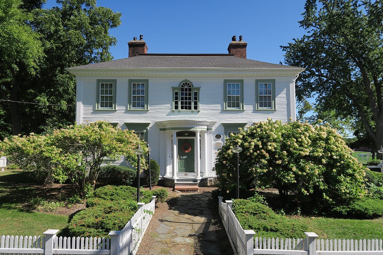
Woodbridge Street Historic DistrictWoodbridge Street Historic District · Photo: John Phelan · CC BY-SA 4.0
A+Outdoors
Outdoors in South Hadley

South Hadley has 58 miles of mapped trails, 3.3 for every square mile of land

31% of South Hadley’s land is conserved, about 3,473 acres. 2,979 acres are parks and preserves, 168 per 1,000 residents. Virtually every resident lives within a half mile of a park.

Among the top 1% of U.S. towns · #19 of 283 in Massachusetts. What drives it

Conserved land
31%
3,473 acres · of 17.7 sq mi of land
Trails
58 mi
3.3 per sq mi of land
Park land
2,979 ac
168 acres per 1,000 residents
Near a park
99%+
of residents within ½ mile
Bike routes
3.8 mi
3.8 mi lanes
Highest peak
988 ft
Bare Mountain
Lakes & rivers
10
1 boat launch

What kind of outdoors town is South Hadley?

Read from the map. The page puts what stands out first.

Outdoors grade

How much outdoors does South Hadley have?

On conserved land, trails, park land and how close residents live to a park, South Hadley is among the top 1% of U.S. towns, #19 of 283 in Massachusetts. All four inputs put South Hadley near the top nationally; trail miles rank highest.

A+
OutdoorsA character grade: shown, never part of South Hadley’s overall grade.
All U.S. towns we grade (21,298)Among the top 1%
LessMore
Massachusetts towns of 2,500+ (283)Ahead of 94%

Massachusetts towns conserve more land than most (a typical one, 21%; the U.S., 4%), so South Hadley’s 31% is ahead of 74% of Massachusetts towns, while its trails per square mile lead 79% of them.

How sure. Graded on any three of the four inputs instead, the letter would still be A+. Trails and many small parks come from OpenStreetMap, mapped by volunteers, so coverage varies from town to town; the half mile is a straight line from each census block, so a river or highway in the way isn’t counted against it.

PAD-US, OpenStreetMap (© OpenStreetMap contributors), Census 2025 Gazetteer and 2020 blocks; details in Sources below. How TownRatings grades the outdoors →

The map

Conserved land, trails & bike routes

Tap a number to zoom to a park. Tap a layer to hide it.

12345678
Easements protect land from building but are usually private.© OpenStreetMap contributors · USGS PAD-US
Places to walk

Pick a walk

The longest trail network is Mount Holyoke Range State Park, with 10.3 miles. Directions go to the nearest trailhead or public parking.

Mount Holyoke Range State Park

Managed by Massachusetts Department of Conservation & Recreation
1,024 acres10.3 mi of trail
NET/M&M Trail (white)Lithia Springs TrailFalling BridgeRFT (orange)+1
Dog rules not recorded
Directionsto the parking lotWebsite ↗

Bynan Conservation Area

Nature preserve
163 acres4.4 mi of trail
yellow blazesblue blazesorange blazesred blazes+1
Dog rules not recorded
No trailhead mapped yet

Joseph Allen Skinner State Park

Nature preserve
360 acres3.6 mi of trail
Dry Brook TrailThermopylae AccessLithia Springs TrailNET/M&M Trail (white)+1
Dog rules not recorded
Directionsto the parking lotWebsite ↗

Bachelor Brook/Stony Brook Resource Area

Nature preserve
286 acres3 mi of trail
River to Range Trail
Dog rules not recorded
Directionsto the parking lot

Black/Stevens Conservation Area

Nature preserve
47 acres1.7 mi of trail
Main Trail (orange rectangle blaze)Ladyslipper Trail (blue rectangle blaze)Plains School Trail (red rectangle blaze)Border Trail (green/teal rectangle blaze)
Dog rules not recorded
Directionsto the parking lot

Mount Holyoke Range Conservation Area

Managed by Town of South Hadley Conservation Commission
246 acres1.2 mi of trail
Lithia Springs TrailNET/M&M Trail (white)Dry Brook Trail
Dog rules not recorded
Directionsto the parking lot

Lyman Conservation Restriction

Nature preserve
58 acres0.8 mi of trail
Dog rules not recorded
No trailhead mapped yet

Jones Newton Property

Nature preserve
38 acres0.8 mi of trail
Dog rules not recorded
No trailhead mapped yet
All 29 parks & preserves
Mount Holyoke Range State Park1,024 acres · 10.3 mi of trail · Massachusetts Department of Conservation & Recreation
Directions
Bynan Conservation Area163 acres · 4.4 mi of trail
Joseph Allen Skinner State Park360 acres · 3.6 mi of trail
Directions
Bachelor Brook/Stony Brook Resource Area286 acres · 3 mi of trail
Directions
Black/Stevens Conservation Area47 acres · 1.7 mi of trail
Directions
Mount Holyoke Range Conservation Area246 acres · 1.2 mi of trail · Town of South Hadley Conservation Commission
Directions
Lyman Conservation Restriction58 acres · 0.8 mi of trail
Jones Newton Property38 acres · 0.8 mi of trail
Hadley Falls Canal Park11 acres · 0.5 mi of trail
Directions
Lithia Springs59 acres · 0.4 mi of trail
Wilderness Area18 acres · 0.4 mi of trail
Directions
South Hadley Canal Park5 acres · 0.3 mi of trail
Directions
Brockway Conservation Restriction29 acres · 0.2 mi of trail · DCR - Division of State Parks and Recreation
Itner Smith Property14 acres · 0.2 mi of trail
Directions
Stone Hill Conservation Area57 acres · 0.1 mi of trail · Town of South Hadley Conservation Commission
Buttery Brook Park42 acres
Directions
Leaping Well Res.30 acres
Directions
Camp Lewis Perkins22 acres
Warner Conservation Area13 acres
Beachgrounds Park6 acres
Directions
Conservation Land5 acres
Titus Pond4 acres
Directions
Hawkins Bird Sanctuary3 acres · Town of South Hadley Conservation Commission
Skinner Green3 acres · Mount Holyoke College
Directions
Woodlawn Field2 acres
Directions
Leaping Well North2 acres
Directions
Abbey Chapel Green1 acres · Mount Holyoke College
Directions
Dickinson Backyard1 acres
Directions
Abbey Green1 acres
Directions
Who protects it

3,473 conserved acres

31% of South Hadley’s land. Who manages South Hadley’s conserved land, from the USGS Protected Areas Database. Approximate, because parcels can overlap.

Town or city554 ac
Other state land388 ac
Land trusts & nonprofits158 ac
State parks126 ac
USDA easements (NRCS)118 ac
Other or Unknown Federal Land101 ac
Joint101 ac
State Park · 1,452 acLocal Other or Unknown · 1,070 acAgricultural Easement · 606 acConservation Easement · 340 acPrivate Other or Unknown · 207 ac
Good to know

Conserved doesn’t always mean open to visitors. 569 acres are conservation easements, usually private land. Public access isn’t recorded for 2 of 95 parcels. The walks above are places people visit.

The biggest protected parcels
Parcel (PAD-US)Managed byAcresPublic access
Mount Holyoke Range State Park
State Park
Not recorded1,021Open
J.A. Skinner State Park
State Park
State parks431Open
Bachelor Brook/Stony Brook Resource Area
Local Other or Unknown
Town or city284Open
Ledges Golf Club
Local Other or Unknown
Not recorded210Open
The Orchards Golf Club
Private Other or Unknown
Not recorded192Restricted
Mount Holyoke Range Conservation Area
Local Other or Unknown
Not recorded163Closed
Bynan Conservation Area
Local Other or Unknown
Not recorded139Open
Bare Mountain Conservation Area
Local Other or Unknown
Not recorded66Open
Leaping Well Res.
Local Conservation Area
Town or city37Open
Town Farm
Local Park
Town or city33Open

5 smaller protected places aren’t shown.

Things to do

11 places to go in South Hadley

Beaches, playgrounds, peaks, falls and more. Pick a kind.

Peaks in South Hadley
Bare Mountain988 ft elevation
Directions
Mount Hitchcock968 ft elevation · In Mount Holyoke Range State Park
Directions
Prospect Hill322 ft elevation
Directions
Dry Brook Hill269 ft elevation
Directions
Trails & water

25 named trails and 10 lakes & rivers

Named trails
Open to bikes · 20.2 miHorses · 1.3 miUnpaved · 29.8 mi
Lithia Springs Trail3.3 mi
NET/M&M Trail (white)2.3 mi
River to Range Trail1.5 mi
Dry Brook Trail1.4 mi
yellow blazes1.2 mi
Main Trail (orange rectangle blaze)1.0 mi
blue blazes0.7 mi
Leaping Well Nature Trail0.7 mi
Lithia Bypass0.7 mi
Thermopylae Access0.7 mi
15 more trails
Falling Bridge
0.6 mi
Maze Road (alt)
0.6 mi
red blazes
0.6 mi
Lithia Outlook Trail/RFT (orange)
0.6 mi
RFT (orange)
0.5 mi
Equestrian Center Path
0.5 mi
Mt. Hitchcock
0.5 mi
Black Rock Trail
0.5 mi
orange blazes
0.5 mi
Lithia Springs Trail/RFT (orange)
0.4 mi
Low Place Trail
0.3 mi
Low Place Trail/RFT (orange)
0.3 mi
NET/M&M/RFT Trail (white/blue/orange)
0.3 mi
Black Rock Trail/RFT (orange)
0.3 mi
Border Trail (green/teal rectangle blaze)
0.3 mi
Lakes & rivers tap for directions
Biking & sports

3.8 miles of bike routes

Bike lanes are often missing from the map in smaller towns, so that number is likely low.

3.8 mi
painted or protected bike lanes
Courts & fields
16Tennis
8Baseball
8Tracks
6Basketball
1Football
1Soccer
1Field hockey
1Lacrosse

Includes school and college facilities, which aren’t always open to the public.

History along the way

3 places on the National Register

The country’s official list of places worth saving (National Park Service). The map also marks 3 historic points from OpenStreetMap: plaques, memorials and old buildings.

History →
Woodbridge Street Historic DistrictDistrict · listed 1983
About it
US Post Office-South Hadley MainBuilding · listed 1986
About it
First Congregational ChurchBuilding · listed 2020
About it
When to get out

The best walking months in South Hadley: April to August

NOAA’s 1991–2020 normals for the town and the daylight at its latitude. Outlined months have long days, highs of 59 to 86 °F and little rain for the place.

JanFebMarAprMayJunJulAugSepOctNovDec
Daylight (h)9.410.511.813.314.615.215.013.912.411.09.79.1
High (°F)353846607179848375635140
Rain (in)3.32.93.53.73.74.44.14.24.54.63.44.0

February is the driest month (2.9 in) and July the warmest (highs of 84 °F). 4.6 inches fall in October, the wettest month. The climate in South Hadley →

Next door

South Hadley and its neighbors

Tap a town to see its outdoors.

TownConserved
of land
Trail mi
per sq mi
Park acres
per 1,000
Near a park
½ mile
Outdoors
South Hadley31%3.316899%+A+
Holyoke41%4.012899%+A+
Granby26%2.453161%A+
Hadley42%2.635465%A+
Amherst Town35%4.09599%+A+
Chicopee4%1.71490%A−

The four inputs of the Outdoors grade, from the engine; shares are of land, not water.

Questions about parks and trails in South Hadley

Where can I hike in South Hadley?

The longest trail networks: Mount Holyoke Range State Park, 10.3 miles; Bynan Conservation Area, 4.4 miles; Joseph Allen Skinner State Park, 3.6 miles; Bachelor Brook/Stony Brook Resource Area, 3 miles. Each one is on the map above, with directions to the nearest trailhead or parking.

How much of South Hadley is conserved land?

31% of its land, against a typical 21% for a Massachusetts town and 4% nationally (PAD-US). Conserved doesn’t always mean open to visitors: easements are usually private land.

Are dogs allowed on South Hadley’s trails?

Mount Holyoke Range State Park and Bynan Conservation Area don’t have dog rules recorded on the map; check the signs at the trailhead.

Where can I bike in South Hadley?

3.8 miles of bike routes are on the map: 3.8 of painted or protected lanes.

Is there public land near South Hadley?

47,078 acres of parks and open public land lie inside South Hadley or within 10 miles of it (PAD-US), 2,984 of them inside the town line.

How much outdoors does South Hadley have?

Among the top 1% of U.S. towns on the Outdoors grade, #19 of 283 in Massachusetts. The grade combines the share of land that is conserved, miles of mapped trail per square mile of land, park acres per 1,000 residents and the share of residents within a half mile of a park. It’s a character grade, so it isn’t part of the overall grade. How it works.

Trail talk

Conditions, parking and favorite walks from South Hadley neighbors.
Town Square →
Share a tip
Sources

Where this page comes from

Conserved and public land: USGS Protected Areas Database of the United States (PAD-US), service updated July 2026. Parks, trails, playgrounds, beaches and other places: OpenStreetMap (© OpenStreetMap contributors, ODbL), map data as of 2026-10-28. Land and water area: Census 2025 Gazetteer. Residents near a park: 2020 Census blocks. National Register: National Park Service. How TownRatings grades the outdoors →