Shirley dates to 1720, and 20% of its homes were built before 1940
More historic than 97% of U.S. towns · #55 of 283 in Massachusetts. What drives it
3 places in town are on the National Register, among them two historic districts with 345 buildings between them. Below: 5 old photos and papers, maps from 1893 on, and the census since 1790.
Founding year: Wikidata. First post office: 1811.The full story ↓
History grade
What drives Shirley’s History grade
On its age, its old homes and the National Register, Shirley is more historic than 97% of U.S. towns, #55 of 283 in Massachusetts. All 3 inputs are above most U.S. towns; its age ranks highest and its share of homes from before 1940 lowest.
A+
HistoryA character grade: shown, never part of Shirley’s overall grade.
Massachusetts towns list more on the Register than most of the country (a typical Massachusetts town has 46.0 per 10,000 residents, the U.S. 2.4), so Shirley’s 496 sits above most of its state (91% of Massachusetts towns have fewer) while its 346 historic buildings outnumber those of 96% of U.S. towns.
NoteThe founding year comes from Wikidata alone; no second source gives 1720.
How sure. Graded on any two of the three inputs instead, the letter would range from A to A+. The pre-1940 share is a Census survey estimate (±8.9 points).
Founding year: Wikidata (other dates in Quick answers). Homes: Census ACS 2020–24. National Register: National Park Service, May 2026 list; each listing counted once (boundary changes and added documentation belong to their listing), and a historic district counts its contributing buildings. How TownRatings grades history →
What stands out about Shirley’s past
Read from the archive, the National Register and the record. The page puts what stands out first.
The inhabitants at the time of European encounter were Nipmuc (or Pennacook) Indians, who called the area Catacunemaug. Once part of "The Plantation of Groton," Shirley was first settled by English pioneers about 1720.
In 1753 it separated from Groton and was incorporated, named in honor of William Shirley, governor of Massachusetts (1741–1757). The town established a paper mill around 1790, and the first of seven cotton mills in 1812. Other local products included iron, nails, textiles, rope, belts, suspenders, and athletic equipment. Two of the large 19th-century mill buildings have been subdivided and adapted for use by 21st-century businesses.
Passages that mention Shirley, cut from the printed page as they were published.
William Shirley, governor of Massachusetts, 1741-1756, a history1920 · page 211Read the page →
Read the text
The question of provisions at Louisburg was obviously acute, another sign of which was the effort of Duquesnel to secure an agreement from Shirley to a neutrality in regard to the English and French fisheries in North American waters (after the English fishing post at Canso had been destroyed). This Shirley declared he was unable to agree to, and pointed out in a letter home that the French not only had great need of the fishery but would employ a
Text read by machine from the scan; it may contain errors.
William Shirley, governor of Massachusetts, 1741-1756, a history1920 · page 214Read the page →
Read the text
be a proper time to consider the matter but September 6th held a council of war and conducted negotiations for three or four days for surrender. However, as the coming of the French expedition was uncertain, these were broken off, and nine days later Shirley's third reinforcement, of Indian rangers, arrived, and the besiegers retired leaving only a covering body of Indians. Shirley to Board, Oct. 4, 1744, C. 0. 5 884, Ff, 33; Shirley to Board, Oct. 16, 1744, Sh. Cor., vol. i, p. 150; Shirley to Newcastle, Oct. 21, 1744, C. 0. 5 900, 132;
Text read by machine from the scan; it may contain errors.
Scans and text from the Internet Archive. Books published in 1930 or earlier, which are in the public domain.
By decade
Shirley, decade by decade
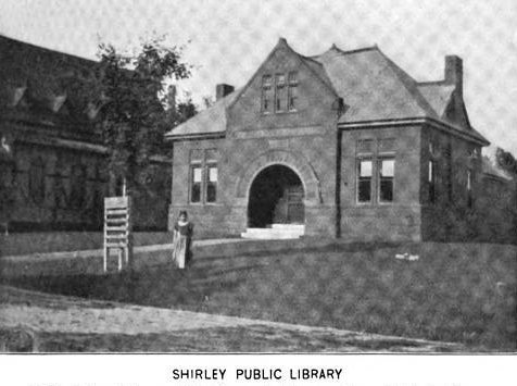
3 decades in the archive, from the 1880s to the 1900s. Scroll each row; tap a photo for its story.
Nothing in the archives for these yearsWeddings on Main Street, storms, parades, school pictures, the old store. If it’s in your family album, it belongs here.
In 1720, according to Wikidata. Shirley’s post office opened in 1811, and the first U.S. census counted 677 people here in 1790.
How does Shirley rank for history?
Shirley is more historic than 97% of U.S. towns, #55 of 283 in Massachusetts. The History grade combines the town’s founding era, the share of homes built before 1940 and its National Register listings. It’s a character grade, so it isn’t part of the overall grade. How it works.
What is on the National Register in Shirley?
Three places: the James Parker House (listed 1988), the Shirley Center Historic District (1988) and the Shirley Village Historic District (1992).
How old are the homes in Shirley?
20% of Shirley’s homes were built before 1940 (Census estimate, ±8.9 points), against a typical 21% for a Massachusetts town; the median home was built in 1984.
Founding dates: Wikidata, Wikipedia, the U.S. post office records of Blevins & Helbock (CC0) and the Census. Homes by year built: Census ACS 2020–24. National Register of Historic Places: National Park Service (list of May 22, 2026). Old photos, postcards and papers: Wikimedia Commons, the Library of Congress and other public archives, credited on each item’s page. Maps: U.S. Geological Survey historical topographic maps (via Esri) and Sanborn fire-insurance maps (Library of Congress). History text and census tables: Wikipedia (CC BY-SA 4.0). Places that used to be: USGS Geographic Names Information System (2021).
From Wikimedia Commons (6), the National Register of Historic Places (3), Wikipedia, Wikidata and Wikipedia for famous people, U.S. Geological Survey historical maps, U.S. Census counts (via Wikipedia), the US Post Offices dataset (Blevins & Helbock), the USGS Geographic Names Information System, Sanborn fire insurance maps (Library of Congress) and old county and town histories (Internet Archive). Archive images are copied here with their credits and licenses, shown on each photo’s page. Refreshed monthly.




 1889
 1907–1915
 2002


