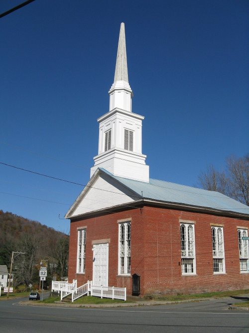
Colrain dates to 1735, and 38% of its homes were built before 1940
Among the most historic 1% of U.S. towns. What drives it
2 places in town are on the National Register, among them a historic district with 75 buildings. Below: 2 old photos and papers, maps from 1890 on, and the census since 1790.
Founding year: Wikidata; Wikipedia’s history section gives the same year. First post office: 1813.The full story ↓
History grade
What drives Colrain’s History grade
On its age, its old homes and the National Register, Colrain is among the most historic 1% of U.S. towns. All 3 inputs put Colrain near the top nationally; its age ranks highest.
A+
HistoryA character grade: shown, never part of Colrain’s overall grade.
Massachusetts towns list more on the Register than most of the country (a typical Massachusetts town has 46.0 per 10,000 residents, the U.S. 2.4), so Colrain’s 461 sits above most of its state (90% of Massachusetts towns have fewer) while its 75 historic buildings outnumber those of 88% of U.S. towns.
How sure. Graded on any two of the three inputs instead, the letter would still be A+. The pre-1940 share is a Census survey estimate (±7.6 points). Two sources give 1735.
Founding year: Wikidata (other dates in Quick answers). Homes: Census ACS 2020–24. National Register: National Park Service, May 2026 list; each listing counted once (boundary changes and added documentation belong to their listing), and a historic district counts its contributing buildings. How TownRatings grades history →
What stands out about Colrain’s past
Read from the archive, the National Register and the record. The page puts what stands out first.
Colrain was first settled in 1735 as "Boston Township No. 2", organized into an independently governing town body in 1745, and was officially incorporated on June 30, 1761.
Although originally named Colrain in 1745, and officially incorporated under that name in 1761, the town spelled its name (and appeared on maps) as "Colraine" for over 112 years until in 1873 the Commonwealth of Massachusetts insisted that the town begin to spell its name as it was officially incorporated.
Colrain has nine historic village areas: Elm Grove, Lyonsville, Foundry Village, Shattuckville, Griswoldville, Colrain City, Catamount Hill, Stewartville, and Gimletville. Much of the town's land area lies outside of these villages.
Passages that mention Colrain, cut from the printed page as they were published.
History of the town of Bernardston, Franklin county, Massachusetts. 1736-1900. With genealogies1902 · page 390Read the page →
Read the text
Burk's enlistment roll ending Nov. 30, 1758. He was in Capt. Williams' Co., stationed at Colrain, Oct. 19, 1756, to Jan. 23, 1757. In 1760 he resided on Gamaliel Kingsley's place, east of the present iron bridge at the village. Sept. 2 i , 1764, he had laid out to him the draft No. 26, 3rd division, with two acres added for roads. The house which he owned at one time is still standing upon the Newcomb road, North Bernardston. He was of Deerfield, 1741. He m. in Lebanon,
Text read by machine from the scan; it may contain errors.
History of the town of Bernardston, Franklin county, Massachusetts. 1736-1900. With genealogies1902 · page 100Read the page →
Read the text
As to the faithfulness of the representations of the defense the existing highways and bridges to-day bear witness. Colrain citizens themselves, although carrying the vote favoring annexation, did so in the face of strong opposition from those resident in the west portion of the town. The parent town carried on the opposition to the movement until 1779, when it was finally voted that that portion of the town lying west of Green River be annexed to Colrain, thus surrendering 2576 acres of land. At this date it is sup-
Text read by machine from the scan; it may contain errors.
History of the town of Ashfield, Franklin County, Massachusetts from its settlement in 1742 to 19101910 · page 69Read the page →
Read the text
By the foregoing dates it will be seen that the settlers were really absent but a few months. About the time the guard was sent to Huntstown, guards were also stationed at the two forts in Charlemont and at two forts in Colrain. Scouts were also continually scouring the woods westward, and any sign of the enemy was quickly reported to the settlements, and with all these precautions the inhabitants felt a sense of partial sectuity.
Text read by machine from the scan; it may contain errors.
History of the town of Ashfield, Franklin County, Massachusetts from its settlement in 1742 to 19101910 · page 57Read the page →
Read the text
by their relatives. Probably .some made trips to the place and if they liked other lots better than their own they could easily be bought. Wild lands in the west of the province sold at a low price. In 1737 what is now the town of Colrain — then Boston No. 2 — was sold for £1320 or about 19 cents an acre. Twenty years later by order of the General Court, ten townships were sold at auction. Among them Hawley sold for £875, Rowe, £380, and other towns accordingly. The previous records have
Text read by machine from the scan; it may contain errors.
Scans and text from the Internet Archive. Books published in 1930 or earlier, which are in the public domain.
Timeline
Colrain, 1735 to 1938
Woven from the archive, old maps, post office records, the National Register and the people born here.
Nothing in the archives for these yearsWeddings on Main Street, storms, parades, school pictures, the old store. If it’s in your family album, it belongs here.
In 1735, according to Wikidata and Wikipedia’s history of the town. Colrain’s post office opened in 1813, and the first U.S. census counted 1,417 people here in 1790.
How does Colrain rank for history?
Colrain is among the most historic 1% of U.S. towns. The History grade combines the town’s founding era, the share of homes built before 1940 and its National Register listings. It’s a character grade, so it isn’t part of the overall grade. How it works.
What is on the National Register in Colrain?
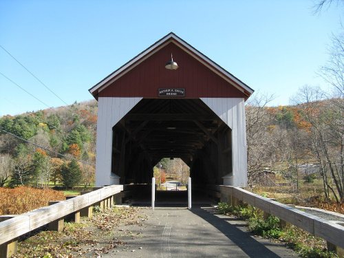
Two places: the Smith, Arthur A., Covered Bridge (listed 1983) and the Colrain Center Historic District (2006).
How old are the homes in Colrain?
38% of Colrain’s homes were built before 1940 (Census estimate, ±7.6 points), against a typical 21% for a Massachusetts town; the median home was built in 1963.
Founding dates: Wikidata, Wikipedia, the U.S. post office records of Blevins & Helbock (CC0) and the Census. Homes by year built: Census ACS 2020–24. National Register of Historic Places: National Park Service (list of May 22, 2026). Old photos, postcards and papers: Wikimedia Commons, the Library of Congress and other public archives, credited on each item’s page. Maps: U.S. Geological Survey historical topographic maps (via Esri) and Sanborn fire-insurance maps (Library of Congress). History text and census tables: Wikipedia (CC BY-SA 4.0). Places that used to be: USGS Geographic Names Information System (2021).
From Wikimedia Commons (11), Wikidata (1), the National Register of Historic Places (2), Wikipedia, Wikidata and Wikipedia for famous people, U.S. Geological Survey historical maps, U.S. Census counts (via Wikipedia), the US Post Offices dataset (Blevins & Helbock), the USGS Geographic Names Information System and old county and town histories (Internet Archive). Archive images are copied here with their credits and licenses, shown on each photo’s page. Refreshed monthly.




 2019
 2014
 2013
 2013
 2013
 2009
 2009
 2008
 2004