Adams dates to 1762, and 55% of its homes were built before 1940
Among the most historic 1% of U.S. towns · #26 of 283 in Massachusetts. What drives it
16 places in town are on the National Register, among them two historic districts with 79 buildings between them. Below: 8 old photos and papers, maps from 1884 on, and the census since 1790.
Founding year: Wikidata. First post office: 1809.The full story ↓
History grade
What drives Adams’ History grade
On its age, its old homes and the National Register, Adams is among the most historic 1% of U.S. towns, #26 of 283 in Massachusetts. All 3 inputs are above most U.S. towns; its share of homes from before 1940 ranks highest and its National Register listings lowest.
A+
HistoryA character grade: shown, never part of Adams’ overall grade.
Massachusetts towns list more on the Register than most of the country (a typical Massachusetts town has 46.0 per 10,000 residents, the U.S. 2.4), so Adams’ 134 sits above most of its state (69% of Massachusetts towns have fewer) while its 108 historic buildings outnumber those of 90% of U.S. towns.
NoteThe founding year comes from Wikidata alone; no second source gives 1762.
How sure. Graded on any two of the three inputs instead, the letter would still be A+. The pre-1940 share is a Census survey estimate (±5.6 points).
Founding year: Wikidata (other dates in Quick answers). Homes: Census ACS 2020–24. National Register: National Park Service, May 2026 list; each listing counted once (boundary changes and added documentation belong to their listing), and a historic district counts its contributing buildings. How TownRatings grades history →
What stands out about Adams’ past
Read from the archive, the National Register and the record. The page puts what stands out first.
National Park Service, National Register of Historic Places. Photos from Wikimedia Commons, credited on each place’s page.
Every building
Adams, building by building, 1884–1914
Fire insurance maps drew every building, what it was made of and what it was used for, so insurers could price the risk of fire. Pick a year, then a sheet.
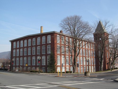
Nathan Jones purchased the township of East Hoosac at auction in 1762 from the Province of Massachusetts Bay for £3,200. In 1778, the town was officially incorporated as Adams, named in honor of Samuel Adams, a revolutionary leader and signer of the Declaration of Independence. Much of the land had been subdivided into 100-acre (40 ha) and 200-acre (81 ha) lots. These were mostly farms with frontage on the Hoosic River, which over time would provide water power for woolen, cotton, lumber, and plastic mills.
Passages that mention Adams, cut from the printed page as they were published.
History of the Thomas Adams and Thomas Hastings families, of Amherst, Massachusetts1880 · page 33Read the page →
Read the text
born Feb. 24, 1873) ; (3) Herbert O., born Oct. 18, 1859 ; (8) Louisa, born July 18, 1819, married * Alden Adams of Leverett is the only Adams west of Brook field who has heretofore interested himself in tracing the genealogy of the Thomas Adams Family and to him the compiler of this record fools greatly indebted. It wns a history of the Ward family, (owned by Allien Adams and to which he made the Adams contributions) that first pat the author of this history on the track of Thomas Adams
Text read by machine from the scan; it may contain errors.
History of the Thomas Adams and Thomas Hastings families, of Amherst, Massachusetts1880 · page 24Read the page →
Read the text
HE was the first settler of our line in this countrj' and the ancestor of the Braintree and Tboraas Adams Families. It was believed by John Quiney Adams that the above Henry came from Braintree, Essex County, England, about 1C34. This is now the more approved view ; it was formerly believed that he came from Devonshire, England, and President John Adams erected a monument in Quiney to his
Text read by machine from the scan; it may contain errors.
History of North Adams, Mass., 1749-1885 [electronic resource]1885 · page 103Read the page →
Read the text
In the summer of 1884 the town of Nortli Adams received a great impetus in the way of building. Large brick business houses were built, as well as private tenements. On Main street was built the new Korth Adams Savings Bank building, with its handsome granite front ; on Bank street was built the Reardon and Wright brick blocks, with pressed brick and marble fronts ; on State street was erected the H. W. Clark block, for a wholesale grocery store, and on Ashland street the shoe factory of Whitman,
Text read by machine from the scan; it may contain errors.
Scans and text from the Internet Archive. Books published in 1930 or earlier, which are in the public domain.
Timeline
Adams, 1762 to 1961
Woven from the archive, old maps, post office records, the National Register and the people born here.
Nothing in the archives for these yearsWeddings on Main Street, storms, parades, school pictures, the old store. If it’s in your family album, it belongs here.
In 1762, according to Wikidata. Adams’ post office opened in 1809, and the first U.S. census counted 2,040 people here in 1790.
How does Adams rank for history?
Adams is among the most historic 1% of U.S. towns, #26 of 283 in Massachusetts. The History grade combines the town’s founding era, the share of homes built before 1940 and its National Register listings. It’s a character grade, so it isn’t part of the overall grade. How it works.
What is on the National Register in Adams?
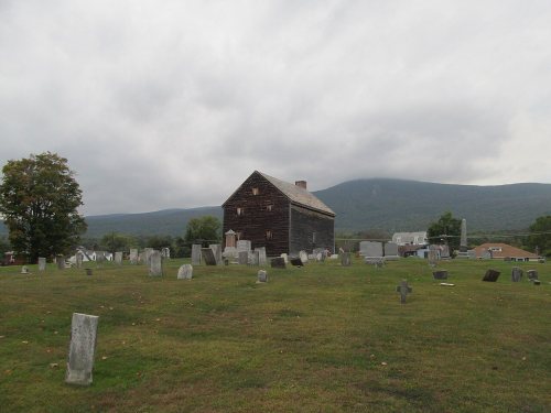
16 listings: 13 buildings, among them the Quaker Meetinghouse (listed 1976, the first), 2 historic districts, the Summer Street Historic District and the Mount Greylock Summit Historic District, with 79 contributing buildings, and 1 site. 108 historic buildings in all.
How old are the homes in Adams?
55% of Adams’ homes were built before 1940 (Census estimate, ±5.6 points), against a typical 21% for a Massachusetts town; the median home was built in 1938.
Founding dates: Wikidata, Wikipedia, the U.S. post office records of Blevins & Helbock (CC0) and the Census. Homes by year built: Census ACS 2020–24. National Register of Historic Places: National Park Service (list of May 22, 2026). Old photos, postcards and papers: Wikimedia Commons, the Library of Congress and other public archives, credited on each item’s page. Maps: U.S. Geological Survey historical topographic maps (via Esri) and Sanborn fire-insurance maps (Library of Congress). History text and census tables: Wikipedia (CC BY-SA 4.0). Places that used to be: USGS Geographic Names Information System (2021).
From Wikimedia Commons (6), the Library of Congress (2), Wikidata (10), the National Register of Historic Places (16), Wikipedia, Wikidata and Wikipedia for famous people, U.S. Geological Survey historical maps, U.S. Census counts (via Wikipedia), the US Post Offices dataset (Blevins & Helbock), the USGS Geographic Names Information System, Sanborn fire insurance maps (Library of Congress) and old county and town histories (Internet Archive). Archive images are copied here with their credits and licenses, shown on each photo’s page. Refreshed monthly.








 1898
 1898
 1898
 1898
 1898
 1898


