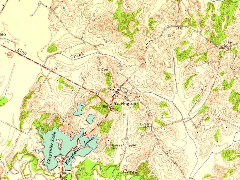
Most of Yelvington was built recently: 4% of its homes predate 1940 and the median home dates from 1987. Below: maps from 1903 on and old-book passages.
The original boundaries of Yelvington were set by the Daviess County Court in 1867.
Yelvington was settled in the early 19th century when it was in the northern portion of Ohio County, KY, by Valentine Husk and James Smeathers, brother of famed pioneer William Smeathers who first settled Yellow Banks, Kentucky; now Owensboro. It was also an early crossroad for the Vincennes, Indiana to Hartford, Kentucky Indian trail and the Yellow Banks trail. This route gave what was to become Daviess county's third primitive overland route of travel.
Passages that mention Yelvington, cut from the printed page as they were published.
History of Daviess County, Kentucky, together with sketches of its cities, villages, and townships, educational religious, civil military, and political history, portraits of prominent persons, biographies of representative citizens, and an outline histor1883 · page 849Read the page →
Read the text
The precinct and village of Yelvington derive their name from Mr. Telverton Overly, one of the earliest settlers of the town, who had a blacksmith shop where the village of Telvingtou now stands; Yelvington is a corruption of Yelverton. Its extreme dimensions each way are iibout eight miles, and its northernmost point, at the mouth of Pup Creek, is the most northern point in the county.
Text read by machine from the scan; it may contain errors.
History of Daviess County, Kentucky, together with sketches of its cities, villages, and townships, educational religious, civil military, and political history, portraits of prominent persons, biographies of representative citizens, and an outline histor1883 · page 852Read the page →
Read the text
It was during this year that the place of worship was changed from Eock Spring to Yelvington. In March, 1855, William Head again became Pastor. In February, 1857, T. jS". Robinson was called, and soon after this the present commodious brick structure was built. Robinion resigned in May, 1859, and K. G. Hay became Pastor. In 1860 the name was changed from Rock Spring to Yelvington. Hay resigned, and J. N". Dawson was called in 1860, and served nearly four years. This was tlie most critical period in
Text read by machine from the scan; it may contain errors.
History of Daviess County Kentucky1883 · page 591Read the page →
Read the text
lerscame afterward. Valentine Husk came from Virginia. He first settled at Yellow Banks, in 1796; then lived on the Ohio River at the mouth of Pup Creek. In 1804 he moved with his family to a point on the Yelvington and Knottsville road, three and a half miles north of the former place, where he began improving the farm afterward owned and occupied by Henry Johnson. He was the first settler in this part of the country. Soon afterward Benjamin, George, Charles and Raleigh Duncan, came
Text read by machine from the scan; it may contain errors.
History of Daviess County Kentucky1883 · page 852Read the page →
Read the text
It was during this year that the place of worship was changed from Rock Spring to Yelvington. In March, 1855, William Head again became Pastor. In February, 1857, T. N. Robinson was called, and soon after this the present commodious brick structure was built. Robinson resigned in May, 1859, and K. G@. Hay became Pastor. In 1860 the name was changed from Rock Spring to Yelvington. Hay resigned, and J. N. Dawson was called in 1860, and served nearly four years. This was the most critical period in
Text read by machine from the scan; it may contain errors.
Scans and text from the Internet Archive. Books published in 1930 or earlier, which are in the public domain.
By decade
No old photos in the archives yet
Weddings on Main Street, storms, parades, school pictures, the old store. If it’s in your family album, it belongs here.
Be the first to add onePhotograph a print flat, in daylight, no flash.
Founding dates: Wikidata, Wikipedia, the U.S. post office records of Blevins & Helbock (CC0) and the Census. Homes by year built: Census ACS 2020–24. National Register of Historic Places: National Park Service (list of May 22, 2026). Old photos, postcards and papers: Wikimedia Commons, the Library of Congress and other public archives, credited on each item’s page. Maps: U.S. Geological Survey historical topographic maps (via Esri) and Sanborn fire-insurance maps (Library of Congress). History text and census tables: Wikipedia (CC BY-SA 4.0). Places that used to be: USGS Geographic Names Information System (2021). How TownRatings grades history →
From Wikipedia, U.S. Geological Survey historical maps, the US Post Offices dataset (Blevins & Helbock), the USGS Geographic Names Information System and old county and town histories (Internet Archive). Archive images are copied here with their credits and licenses, shown on each photo’s page. Refreshed monthly.