The Island post office opened in 1882, the earliest record of the town by name. Another post office, Island Station (1873), opened inside today’s city and later closed.
First census: 647 in 19102020 census: 429144 years
Founding year: the first Island post office (Blevins & Helbock, CC0).The full story ↓
What stands out about Island’s past
Read from the archive, the National Register and the record. The page puts what stands out first.
The city is named for Judge William Worthington's early 19th-century 8-square-mile (21 km2) estate, known as "The Island" from the way high water on the Green and other nearby rivers would maroon it from adjacent land. Between 1829 and 1860, the local post office operated as "Worthington". The Owensboro and Nashville Railroad connected the area in 1872; the station and new post office were known as "Island Station". Both were shortened to "Island" in 1882.
Passages that mention Island, cut from the printed page as they were published.
The Perry memorial and centennial celebration under the auspices of the national government and the states of Ohio, Pennsylvania, Michigan, Illinois, Wisconsin, New York, Rhode Island, Kentucky, Minnesota and Indiana1912 · page 15Read the page →
Read the text
It consists of a reservation of about fourteen acres in extent, with some fourteen hundred feet of water front on both sides, situated in the narrow neck of land at I'ut-in-Bav Island substantially opposite Gibraltar Island and extending northward toward Middle Bass Island. It overlooks the waters of Lake Erie toward \\'est Sister Island, whence Commodore Perry sent his famous message to General Harrison, and in the verv shadow of the memorial will lie Gibraltar Island, where the American
Text read by machine from the scan; it may contain errors.
The Perry memorial and centennial celebration under the auspices of the national government and the states of Ohio, Pennsylvania, Michigan, Illinois, Wisconsin, New York, Rhode Island, Kentucky, Minnesota and Indiana1912 · page 17Read the page →
Read the text
location of a wireless telegraph station capable of receiving and discharging messages over the whole chain of lakes, a life saving station and a meteorological bureau. Inasmuch as Put-in-Bay Island is the only island of the (ireat Lakes connected with the mainland by both telephone and telegraph, and is located almost in the geographical center of Lake Erie, the most treacherous of these waters, a central wireless telegraph station at this point would be able to communicate with all the life saving stations
Text read by machine from the scan; it may contain errors.
Scans and text from the Internet Archive. Books published in 1930 or earlier, which are in the public domain.
Timeline
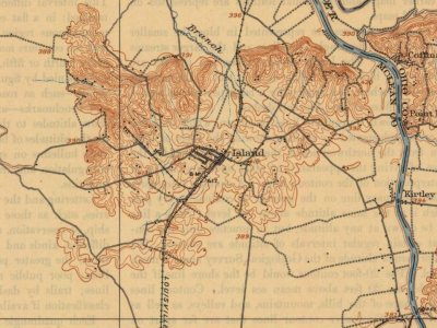
Island, 1873 to 1909
Woven from the archive, old maps, post office records, the National Register and the people born here.
Founding dates: Wikidata, Wikipedia, the U.S. post office records of Blevins & Helbock (CC0) and the Census. Homes by year built: Census ACS 2020–24. National Register of Historic Places: National Park Service (list of May 22, 2026). Old photos, postcards and papers: Wikimedia Commons, the Library of Congress and other public archives, credited on each item’s page. Maps: U.S. Geological Survey historical topographic maps (via Esri) and Sanborn fire-insurance maps (Library of Congress). History text and census tables: Wikipedia (CC BY-SA 4.0). Places that used to be: USGS Geographic Names Information System (2021). How TownRatings grades history →
From Wikimedia Commons (2), Wikipedia, U.S. Geological Survey historical maps, U.S. Census counts (via Wikipedia), the US Post Offices dataset (Blevins & Helbock), the USGS Geographic Names Information System and old county and town histories (Internet Archive). Archive images are copied here with their credits and licenses, shown on each photo’s page. Refreshed monthly.


 2014
 2004


