The Paradise Township post office opened in 1875, the earliest record of the town by name. Wikidata gives 1887. Five smaller post offices, Clarkson (1878), Woodville (1878) and Fairport (1881), opened inside today’s town and later closed.
First census: 178 in 19302020 census: 138151 years
Founding year: the first Paradise Township post office (Blevins & Helbock, CC0). Wikidata: 1887.The full story ↓
What stands out about Paradise Township’s past
Read from the archive, the National Register and the record. The page puts what stands out first.
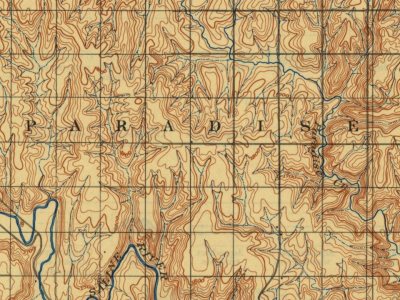
Every edition of the U.S. Geological Survey’s map of Paradise Township. Tap a year, or press play to watch the town change.
1896Osborne sheet · 1:125,000
U.S. Geological Survey historical topographic maps (public domain), via Esri’s collection of the scans. The red ring marks the center of Paradise Township.
In 1859, a hunting party explored the area, including a small tributary of the Saline River which led them to a site abundant in water, timber, and bison. One of the hunters, James R. Mead, described the site as paradise, and the tributary subsequently became known as Paradise Creek. The first post office in the area opened under the name Paradise in 1875. In 1887, the Union Townsite Company established a town on the north side of the creek northwest of the post office, naming it Ivamar after Iva Marr, the daughter of a local rancher. The Paradise post office relocated to Ivamar the next year, but kept its name. As a result, the town came to be known by both names; in 1891, the Union Pacific Railroad listed its rail stop there as Paradise with Ivamar in parentheses. The community grew through the 1890s to include a school, downtown businesses, and railroad facilities, reaching a populat…
Founding dates: Wikidata, Wikipedia, the U.S. post office records of Blevins & Helbock (CC0) and the Census. Homes by year built: Census ACS 2020–24. National Register of Historic Places: National Park Service (list of May 22, 2026). Old photos, postcards and papers: Wikimedia Commons, the Library of Congress and other public archives, credited on each item’s page. Maps: U.S. Geological Survey historical topographic maps (via Esri) and Sanborn fire-insurance maps (Library of Congress). History text and census tables: Wikipedia (CC BY-SA 4.0). Places that used to be: USGS Geographic Names Information System (2021). How TownRatings grades history →
From Wikimedia Commons (3), Wikidata (2), Wikipedia, U.S. Geological Survey historical maps, U.S. Census counts (via Wikipedia), the US Post Offices dataset (Blevins & Helbock) and the USGS Geographic Names Information System. Archive images are copied here with their credits and licenses, shown on each photo’s page. Refreshed monthly.


 2010
 2007
 2007
