Guest, Sign inJoin

Post to Dodge Township

We’ll email a one-tap link to publish your post. No password, and nothing is public until you click it.
Already a member? Sign in
–Not graded
History · Dodge Township

Dodge Township dates to 1872

Most of Dodge Township was built recently: 7% of its homes predate 1940 and the median home dates from 1977. Below: 11 old photos and papers, maps from 1968 on, and the census since 1880.

1872founded
0on the National Register
7%homes built before 1940
11old photos & papers
26famous people
From Dodge Township’s archive · credits on each photo
Quick answers

How Dodge Township began, and where its name came from

When was Dodge Township founded?

1872

Dodge Township dates its founding to 1872 (Wikidata). The census first counted it in 1880.

First census: 996 in 18802020 census: 683154 years

How did Dodge Township get its name?

Dodge Township was named after nearby Fort Dodge, which was named in honor of Grenville Dodge.

Founding year: Wikidata. First post office: 1851. Name: Wikipedia, licensed CC BY-SA 4.0.The full story ↓

What stands out about Dodge Township’s past

Read from the archive, the National Register and the record. The page puts what stands out first.

★ What stands out · Famous people

26 famous people were born in Dodge Township

Writers, athletes, leaders and more, ranked by how widely they’re known.

See all →
The story

How Dodge Township came to be

From Wikipedia’s history of Dodge Township.

Read it all →

The first settlement in the area that became Dodge City was Fort Mann, built by civilians in 1847. The fort was built to provide protection for travelers on the Santa Fe Trail. Fort Mann collapsed in 1848 after an attack by Natives. In 1850, the U.S. Army arrived to provide protection in the region and constructed Fort Atkinson on the old Fort Mann site. The army abandoned Fort Atkinson in 1853. Military forces on the Santa Fe Trail were re-established farther north and east at Fort Larned in 1859, but the area remained vacant around what would become Dodge City until the end of the Civil War. In April 1865, the American Frontier Wars in the West began heating up, and the army constructed Fort Dodge to assist Fort Larned in providing protection on the Santa Fe Trail. Fort Dodge remained in operation until 1882.

Text from Wikipedia, licensed CC BY-SA 4.0.

Timeline

Dodge Township, 1840 to 1970

Woven from the archive, old maps, post office records, the National Register and the people born here.

  1. 19th century
  2. 1840In the archiveUS 1880 Kansas City and Dodge RPO to Lawrence KS Cover
  3. 1851Post officeThe Fort Atkinson post office opens
  4. 1853Post officeThe Fort Atkinson post office closes
  5. 1870In the archiveLong Branch Saloon interior
  6. 1872
    FoundingDodge Township is established
  7. 1880In the archiveKansas. Dodge City. Horse-drawn vehicle
  8. 1894In the archiveDodge City Peace Commission
  9. 20th century
  10. 1906In the archiveMcCarty & McCarty's Private Hospital ("American medical directory", 1906 advert)
  11. 1912Born hereBill Miller is born here
  12. 1925Born hereJames King is born here
  13. 1936Born hereDennis Hopper is born here
  14. 1968On the mapFirst mapped by the U.S. Geological Survey
  15. 1970Born hereDavid A. R. White is born here
By decade

Dodge Township, decade by decade

5 decades in the archive, from the 1840s to the 1900s. Scroll each row; tap a photo for its story.

On the map

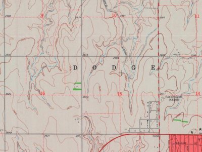
Dodge Township on the map, 1968 to 1984

Every edition of the U.S. Geological Survey’s map of Dodge Township. Tap a year, or press play to watch the town change.

Dodge Township on the 1968 USGS mapDodge Township on the 1978 USGS mapDodge Township on the 1984 USGS map1968Dodge City sheet · 1:24,000

U.S. Geological Survey historical topographic maps (public domain), via Esri’s collection of the scans. The red ring marks the center of Dodge Township.

Then & now

Stand where they stood

No then-and-now pairs yet. Take a photo from the same spot as an old one and they appear here side by side.

US 1880 Kansas City and Dodge RPO to Lawrence KS Cover
Retake this viewUS 1880 Kansas City and Dodge RPO to Lawrence KS Cover, 1840s

Find the spot, match the angle, and add your photo. It becomes the first then-and-now pair on Dodge Township’s page.

Retake this view · +15
People over time

Dodge Township, census by census

05,00010,00015,00020,00025,00030,0001880190019201940196019802000202027,788

Grew from 996 people in 1880 to 27,788 in 2020, more than tenfold.

15 censuses, 1880–2020.

U.S. Census Bureau decennial counts, from the census table on Dodge Township’s Wikipedia page.

Places that used to be

Lost post offices and places now gone

Another post office, Fort Atkinson, opened and closed inside today’s town.

Gone or out of use
Fort Atkinsonmilitary

US Post Offices dataset (Blevins & Helbock, CC0). Places and cemeteries from the USGS Geographic Names Information System (2021).

Help out

Finish Dodge Township’s story

Most archives stop around 1920. The photos from after that are in family albums, not libraries.

Decades since 1900 with photos
00s10s20s30s40s50s60s70s80s90s
1 of 10 decades. The empty ones are waiting for someone’s album.
Stories next door

History across the town line

Each neighbor’s History grade, on the same three inputs.

Questions about Dodge Township’s history

What year was Dodge Township founded?

In 1872, according to Wikidata. Dodge Township’s post office opened in 1851, and the census of 1880 counted 996 people here.

Memory lane

What the archives can’t tell you, neighbors can.

Town Square →
Start a conversation
Sources

Where this page comes from

Founding dates: Wikidata, Wikipedia, the U.S. post office records of Blevins & Helbock (CC0) and the Census. Homes by year built: Census ACS 2020–24. National Register of Historic Places: National Park Service (list of May 22, 2026). Old photos, postcards and papers: Wikimedia Commons, the Library of Congress and other public archives, credited on each item’s page. Maps: U.S. Geological Survey historical topographic maps (via Esri) and Sanborn fire-insurance maps (Library of Congress). History text and census tables: Wikipedia (CC BY-SA 4.0). Places that used to be: USGS Geographic Names Information System (2021). How TownRatings grades history →

From Wikimedia Commons (11), Wikidata (1), Wikipedia, Wikidata and Wikipedia for famous people, U.S. Geological Survey historical maps, U.S. Census counts (via Wikipedia), the US Post Offices dataset (Blevins & Helbock) and the USGS Geographic Names Information System. Archive images are copied here with their credits and licenses, shown on each photo’s page. Refreshed monthly.