Guest, Sign inJoin

Post to Wayne Township

We’ll email a one-tap link to publish your post. No password, and nothing is public until you click it.
Already a member? Sign in
Chenoweth-Coulter FarmhousePhoto: Nyttend · Public domain
–Not graded
History · Wayne Township

40% of Wayne Township’s homes were built before 1940

Its Register listing is the Chenoweth-Coulter Farm. Below: maps from 1950 on and the census since 1890.

1on the National Register
40%homes built before 1940

What stands out about Wayne Township’s past

Read from the archive, the National Register and the record. The page puts what stands out first.

★ What stands out · Help out

Start Wayne Township’s collection

The first neighbors to add old photos shape how Wayne Township’s history is told.

Decades since 1900 with photos
00s10s20s30s40s50s60s70s80s90s
0 of 10 decades. The empty ones are waiting for someone’s album.
Places that used to be

Lost post offices, old corners and burying grounds

Two other post offices opened and closed inside today’s town.

Priceville
1871–1874
Banquo
1882–1903
18701950today
Hamlets and corners on the map
Banquo
1cemetery inside Wayne Township
Gardens of Memory

US Post Offices dataset (Blevins & Helbock, CC0). Places and cemeteries from the USGS Geographic Names Information System (2021).

The story

How Wayne Township came to be

From Wikipedia’s history of Wayne Township.

Read it all →

Wayne Township was organized in 1844. Some of the early settlers being natives of Wayne County, Indiana caused the name to be selected.

The Chenoweth-Coulter Farm was listed on the National Register of Historic Places in 2009.

Text from Wikipedia, licensed CC BY-SA 4.0.

From the old history books

What they wrote about Wayne Township, 1900–1914

Passages that mention Wayne Township, cut from the printed page as they were published.

A society of Disciples was organized in Wayne Township some time in the ’50s and a frame church was built near Banquo a little later. In its early days this church was fairly prosperous, but in recent years it has declined to some extent, though meetings are still held at intervals and the members …
History of Huntington County, Indiana1914 · page 325Read the page →
Read the text

A society of Disciples was organized in Wayne Township some time in the ’50s and a frame church was built near Banquo a little later. In its early days this church was fairly prosperous, but in recent years it has declined to some extent, though meetings are still held at intervals and the members hope to see the work revived.

Text read by machine from the scan; it may contain errors.
About 1850, probably a year or two earlier, a Baptist society was formed in the southern part of Wayne Township and within eighteen months had a strong membership. The schoolhouse was outgrown and in 1852 an unpretentious but comfortable frame house of worship was built in the northwest corner of S…
History of Huntington County, Indiana1914 · page 328Read the page →
Read the text

About 1850, probably a year or two earlier, a Baptist society was formed in the southern part of Wayne Township and within eighteen months had a strong membership. The schoolhouse was outgrown and in 1852 an unpretentious but comfortable frame house of worship was built in the northwest corner of Section 34, about a mile from the Grant First Church Building of the Baptist Church, Erected 1847 County line. Deaths and removals have weakened the congregation to some extent, but meetings are still held.

Text read by machine from the scan; it may contain errors.
Indiana, in the year 1835, and located in Union County, and afterward came to Huntington County, in 1865, where the father departed life about the year 1867 or 1868. The mother is still a resident of Wayne Township, and has reached the advanced age of seventy-seven years, her birth occurring April …
History of Huntington County, Indiana1900 · page 727Read the page →
Read the text

Indiana, in the year 1835, and located in Union County, and afterward came to Huntington County, in 1865, where the father departed life about the year 1867 or 1868. The mother is still a resident of Wayne Township, and has reached the advanced age of seventy-seven years, her birth occurring April 18, 1811, and that of the father November 13, 1808. Our subject came to Huntington County, shortly after his marriage with Miss Cell a

Text read by machine from the scan; it may contain errors.
where he remained until 1840. He then returned to Indiana and from that year until his death in 1886, was an honored resident of Wayne Township. Conspicuous among the arrivals of 1839, was James Campbell, who made a home in the southern part of the township. He early gained considerable notoriety a…
History of Huntington County, Indiana1900 · page 856Read the page →
Read the text

where he remained until 1840. He then returned to Indiana and from that year until his death in 1886, was an honored resident of Wayne Township. Conspicuous among the arrivals of 1839, was James Campbell, who made a home in the southern part of the township. He early gained considerable notoriety as a politician, and the decided stand which he took upon the question of the abolition of slavery was such as to antagonize many of his neighbors, who were

Text read by machine from the scan; it may contain errors.

Scans and text from the Internet Archive. Books published in 1930 or earlier, which are in the public domain.

Timeline

Wayne Township, 1871 to 1950

Woven from the archive, old maps, post office records, the National Register and the people born here.

  1. 19th century
  2. 1871Post officeThe Priceville post office opens
  3. 1874Post officeThe Priceville post office closes
  4. 1882Post officeThe Banquo post office opens
  5. 20th century
  6. 1903Post officeThe Banquo post office closes
  7. 1950On the mapFirst mapped by the U.S. Geological Survey
By decade

No old photos in the archives yet

Weddings on Main Street, storms, parades, school pictures, the old store. If it’s in your family album, it belongs here.

Be the first to add onePhotograph a print flat, in daylight, no flash.
Add from your album
On the map

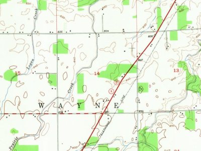
Wayne Township on the map, 1950 to 1969

Every edition of the U.S. Geological Survey’s map of Wayne Township. Tap a year, or press play to watch the town change.

Wayne Township on the 1950 USGS mapWayne Township on the 1969 USGS map1950Mount Etna sheet · 1:24,000

U.S. Geological Survey historical topographic maps (public domain), via Esri’s collection of the scans. The red ring marks the center of Wayne Township.

On the National Register

1 historic place in Wayne Township

The country’s official list of buildings and places worth saving.

place listed
1
National Historic Landmarks
0
none yet
historic buildings protected
8
each building in a district counts
first listed
2009
Chenoweth-Coulter Farm
Buildings

Architectural styles listings

Greek Revival1
Italianate1

National Park Service, National Register of Historic Places. Photos from Wikimedia Commons, credited on each place’s page.

People over time

Wayne Township, census by census

02004006008001,0001900192019401960198020002020Peak: 1,047

Between 470 and 1,047 people in every census since 1890.

14 censuses, 1890–2020.

U.S. Census Bureau decennial counts, from the census table on Wayne Township’s Wikipedia page.

Famous people

Famous people close to Wayne Township

Nobody well known was born in Wayne Township itself, so here are the best known from just nearby.

See all →
Stories next door

History across the town line

Each neighbor’s History grade, on the same three inputs.

Questions about Wayne Township’s history

What is on the National Register in Wayne Township?

One place: the Chenoweth-Coulter Farm (listed 2009).

Memory lane

What the archives can’t tell you, neighbors can.

Town Square →
Start a conversation
Sources

Where this page comes from

Founding dates: Wikidata, Wikipedia, the U.S. post office records of Blevins & Helbock (CC0) and the Census. Homes by year built: Census ACS 2020–24. National Register of Historic Places: National Park Service (list of May 22, 2026). Old photos, postcards and papers: Wikimedia Commons, the Library of Congress and other public archives, credited on each item’s page. Maps: U.S. Geological Survey historical topographic maps (via Esri) and Sanborn fire-insurance maps (Library of Congress). History text and census tables: Wikipedia (CC BY-SA 4.0). Places that used to be: USGS Geographic Names Information System (2021). How TownRatings grades history →

From the National Register of Historic Places (1), Wikipedia, U.S. Geological Survey historical maps, U.S. Census counts (via Wikipedia), the US Post Offices dataset (Blevins & Helbock), the USGS Geographic Names Information System and old county and town histories (Internet Archive). Archive images are copied here with their credits and licenses, shown on each photo’s page. Refreshed monthly.