How Russiaville began, and where its name came from
When was Russiaville founded?
1859
The Russiaville post office opened in 1859, the earliest record of the town by name.
First census: 160 in 18702020 census: 1,319167 years
How did Russiaville get its name?
The town was named for Jean Baptiste de Richardville (whose father's surname was Richerville), a Miami chief of French-Miami descent who had relations with the United States government in treaty making in the early nineteenth century.
More on the name
Through the French pronunciation of "Ri-shar-ville," the name was gradually changed to the current spelling; it has been pronounced "Roo-sha-ville" through much of its history.
How historic is Russiaville?
B−
More historic than 52% of U.S. towns, on its age, its old homes and the National Register.
On its age, its old homes and the National Register, Russiaville is more historic than 52% of U.S. towns. Its share of homes from before 1940 holds the grade up; its age pulls it down.
B−
HistoryA character grade: shown, never part of Russiaville’s overall grade.
Indiana towns list more on the Register than most of the country (a typical Indiana town has 7.9 per 10,000 residents, the U.S. 2.4), so Russiaville’s 6.9 sits near the middle of its state (58% of Indiana towns have fewer) while its 1 listings outnumber those of 51% of U.S. towns.
How sure. Graded on any two of the three inputs instead, the letter would range from C+ to B. The pre-1940 share is a Census survey estimate (±5.8 points). The founding year is the first post office, not a stated founding date.
Founding year: the first post office (other dates in Quick answers). Homes: Census ACS 2020–24. National Register: National Park Service, May 2026 list; each listing counted once (boundary changes and added documentation belong to their listing), and a historic district counts its contributing buildings. How TownRatings grades history →
What stands out about Russiaville’s past
Read from the archive, the National Register and the record. The page puts what stands out first.
Russiaville became a Quaker settlement in the years before the Civil War. They created a stop on the Underground Railroad for fugitive slaves in the antebellum years in nearby New London, then the site of the Friends Meeting serving the entire area. A local legend tells that the stop included a tunnel under New London from a safe house to a cave in the hollow of Honey Creek, near the location of the Friends Meetinghouse.
Russiaville is the birthplace of Jonathan Dixon Maxwell (September 3, 1864), builder of the Maxwell automobile. He is buried there.
The Tribune of December 16, 1908, contains a letter from James W. Cooper, of Russiaville, saying that two other soldiers of the War of 1812 were buried there : Joseph Taylor, who has been mentioned in the Pioneer life of Howard County, was a soldier of the \Yav of 1812, and was buried in the Russiaville cemetery: John Gregg, served under Gen. Willian H. Harrison at Fort ]\Ieigs and was also in the battle of the Thames, where the British, under Gen.
Text read by machine from the scan; it may contain errors.
History of Howard County, Indiana1909 · page 204Read the page →
Read the text
Mr. Stuart's goods, which he traded to the Indians. It required two days for Mr. Stuart and liis man to make the trip, and they spent only two hours in the Indian town. Mr. Stuart's store was not reahy in Russiaville. being just outside on the northwest. !\Iartin Burton was the first merchant really within the limits of Russiaville.
Text read by machine from the scan; it may contain errors.
Scans and text from the Internet Archive. Books published in 1930 or earlier, which are in the public domain.
Timeline
Russiaville, 1859 to 1961
Woven from the archive, old maps, post office records, the National Register and the people born here.
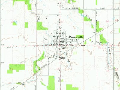
U.S. Geological Survey historical topographic maps (public domain), via Esri’s collection of the scans. The red ring marks the center of Russiaville.
Every building
Russiaville, building by building, 1907–1913
Fire insurance maps drew every building, what it was made of and what it was used for, so insurers could price the risk of fire. Pick a year, then a sheet.
National Park Service, National Register of Historic Places. Photos from Wikimedia Commons, credited on each place’s page.
People over time
Russiaville, census by census
Grew from 160 people in 1870 to 1,319 in 2020, 8 times over.
9 censuses, 1870–2020.
U.S. Census Bureau decennial counts, from the census table on Russiaville’s Wikipedia page.
Questions about Russiaville’s history
What year was Russiaville founded?
The Russiaville post office opened in 1859, the earliest record of the town by name (U.S. post office records).
How does Russiaville rank for history?
Russiaville is more historic than 52% of U.S. towns. The History grade combines the town’s founding era, the share of homes built before 1940 and its National Register listings. It’s a character grade, so it isn’t part of the overall grade. How it works.
What is on the National Register in Russiaville?
One place: the Russiaville Interurban Depot (listed 2022).
How old are the homes in Russiaville?
16% of Russiaville’s homes were built before 1940 (Census estimate, ±5.8 points), against a typical 14% for an Indiana town; the median home was built in 1982.
Founding dates: Wikidata, Wikipedia, the U.S. post office records of Blevins & Helbock (CC0) and the Census. Homes by year built: Census ACS 2020–24. National Register of Historic Places: National Park Service (list of May 22, 2026). Old photos, postcards and papers: Wikimedia Commons, the Library of Congress and other public archives, credited on each item’s page. Maps: U.S. Geological Survey historical topographic maps (via Esri) and Sanborn fire-insurance maps (Library of Congress). History text and census tables: Wikipedia (CC BY-SA 4.0). Places that used to be: USGS Geographic Names Information System (2021).
From Wikimedia Commons (2), the National Register of Historic Places (1), Wikipedia, Wikidata and Wikipedia for famous people, U.S. Geological Survey historical maps, U.S. Census counts (via Wikipedia), the US Post Offices dataset (Blevins & Helbock), the USGS Geographic Names Information System, Sanborn fire insurance maps (Library of Congress) and old county and town histories (Internet Archive). Archive images are copied here with their credits and licenses, shown on each photo’s page. Refreshed monthly.


 2012
 2007

