6 places in town are on the National Register, among them three historic districts with 222 buildings between them. Below: maps from 1885 on and the census since 1850.
Founding year: the first Rockport post office (Blevins & Helbock, CC0).The full story ↓
History grade
What drives Rockport’s History grade
On its age, its old homes and the National Register, Rockport is more historic than 87% of U.S. towns. All 3 inputs are above most U.S. towns; its National Register listings ranks highest and its share of homes from before 1940 lowest.
A
HistoryA character grade: shown, never part of Rockport’s overall grade.
Indiana towns list more on the Register than most of the country (a typical Indiana town has 7.9 per 10,000 residents, the U.S. 2.4), so Rockport’s 1,149 sits above most of its state (99% of Indiana towns have fewer) while its 225 historic buildings outnumber those of 94% of U.S. towns.
How sure. Graded on any two of the three inputs instead, the letter would range from B+ to A+. The pre-1940 share is a Census survey estimate (±4.8 points). The founding year is the first post office, not a stated founding date.
Founding year: the first post office (other dates in Quick answers). Homes: Census ACS 2020–24. National Register: National Park Service, May 2026 list; each listing counted once (boundary changes and added documentation belong to their listing), and a historic district counts its contributing buildings. How TownRatings grades history →
What stands out about Rockport’s past
Read from the archive, the National Register and the record. The page puts what stands out first.
Lots were first sold in Rockport in 1818. The town received its name from rock outcroppings on the Ohio River.
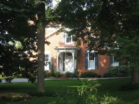
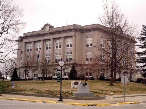
Three locations in Rockport are listed on the National Register of Historic Places: the Spencer County Courthouse, the Mathias Sharp House, and the Lincoln Pioneer Village.
Cleveland-Cliffs Rockport Works is located on the Ohio River near Rockport. The facility has an 80” wide galvanizing line which is the widest in the United States. The hot-dip galvanizing and galvannealing line incorporates proprietary technologies like induction transition heating, which provides rapid, accurate annealing temperature control. Rockport Works is one of the largest employers in Spencer County.
Passages that mention Rockport, cut from the printed page as they were published.
History of the town of Rockport1888 · page 173Read the page →
Read the text
When the Gloucester Branch of the Eastern Road was being constructed, and also after it was opened for travel (in 1 847) the question was agitated by some of our most prominent citizens and business men, of extending the road to Rockport; but the Eastern Railroad Corporation could not be induced to engage in that enterprise. Therefore Ezra Eames and other citizens of Rockport obtained an act of incorporation by the name of the Rockport Railroad Company, by which act they
Text read by machine from the scan; it may contain errors.
History of Camden and Rockport, Maine1907 · page 13Read the page →
Read the text
What has for many years been known as the Camden hme, is of as good quality as any in the state, and the "Jacobs lime" has always been famous in the market. This latter is taken from the quarries lying between Camden and Rockport villages, although the most of the deposit is within the limits of the town of Rockport. There is also a large and rich deposit of this calcareous rock, and extensive quarries worked, near Simontoa's Corner, in the interior of the town of Rockport.
Text read by machine from the scan; it may contain errors.
History of Camden and Rockport, Maine1907 · page 312Read the page →
Read the text
None, 00." ^ On May 27, another meeting was held at which it was voted to " Reconsider the vote of the annual meeting in March last, whereby the Town voted to build a bridge at Rockport" and " expend the money, or any part thereof (which was raised in 1855 for re-building bridge at Rockport) in repairs on said Bridge as it now is." This action did not meet the approval of all the citizens, so another meeting was called on June 7, at
Text read by machine from the scan; it may contain errors.
Scans and text from the Internet Archive. Books published in 1930 or earlier, which are in the public domain.
Timeline
Rockport, 1823 to 1952
Woven from the archive, old maps, post office records, the National Register and the people born here.
Every edition of the U.S. Geological Survey’s map of Rockport. Tap a year, or press play to watch the town change.
1952Rockport sheet · 1:24,000
U.S. Geological Survey historical topographic maps (public domain), via Esri’s collection of the scans. The red ring marks the center of Rockport.
Every building
Rockport, building by building, 1885–1917
Fire insurance maps drew every building, what it was made of and what it was used for, so insurers could price the risk of fire. Pick a year, then a sheet.
The Rockport post office opened in 1823, the earliest record of the town by name (U.S. post office records).
How does Rockport rank for history?
Rockport is more historic than 87% of U.S. towns. The History grade combines the town’s founding era, the share of homes built before 1940 and its National Register listings. It’s a character grade, so it isn’t part of the overall grade. How it works.
What is on the National Register in Rockport?
6 listings: 3 buildings, among them the Mathias Sharp House (listed 1983, the first), and 3 historic districts, the Lincoln Pioneer Village, the Rockport Historic District and the Spencer Courthouse Square Historic District, with 222 contributing buildings. 225 historic buildings in all.
How old are the homes in Rockport?
12% of Rockport’s homes were built before 1940 (Census estimate, ±4.8 points), against a typical 14% for an Indiana town; the median home was built in 1973.
Founding dates: Wikidata, Wikipedia, the U.S. post office records of Blevins & Helbock (CC0) and the Census. Homes by year built: Census ACS 2020–24. National Register of Historic Places: National Park Service (list of May 22, 2026). Old photos, postcards and papers: Wikimedia Commons, the Library of Congress and other public archives, credited on each item’s page. Maps: U.S. Geological Survey historical topographic maps (via Esri) and Sanborn fire-insurance maps (Library of Congress). History text and census tables: Wikipedia (CC BY-SA 4.0). Places that used to be: USGS Geographic Names Information System (2021).
From Wikimedia Commons (5), Wikidata (1), the National Register of Historic Places (6), Wikipedia, Wikidata and Wikipedia for famous people, U.S. Geological Survey historical maps, U.S. Census counts (via Wikipedia), the US Post Offices dataset (Blevins & Helbock), the USGS Geographic Names Information System, Sanborn fire insurance maps (Library of Congress) and old county and town histories (Internet Archive). Archive images are copied here with their credits and licenses, shown on each photo’s page. Refreshed monthly.


 2011
 2011
 2011
 2011
 2007


