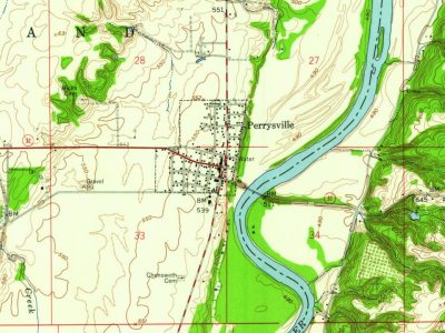
Perrysville was platted and surveyed in 1825 by James Blair on a bluff on the west side of the Wabash River. The town is named for Commodore Oliver Hazard Perry, the hero of the Battle of Lake Erie. It became a local center for shipping products to New Orleans on flatboats via the Wabash, Ohio, and Mississippi Rivers, and it was also able to receive heavy equipment and manufactured items on steamboats. Prior to the advent of the railroad in the second half of the nineteenth century, the town's location on the river made for a thriving community; it is reputed to have been the largest town between Chicago and Terre Haute at the height of its success. The arrival of the Wabash and Erie Canal enhanced its importance even further; a sidecut with locks allowed boats to be towed across the river to the town. Various roads intersected here, including a plank toll road from Danville, Illinois t…
Passages that mention Perrysville, cut from the printed page as they were published.
Biographical and historical record of Vermillion County, Indiana1888 · page 299Read the page →
Read the text
The village of Gessie, on the railroad three miles northwest of Perrysville station, was (i M
Text read by machine from the scan; it may contain errors.
Biographical and historical record of Vermillion County, Indiana1888 · page 184Read the page →
Read the text
a general level of 120 to 130 feet above the river, and form the slightly elevated border of Grand Prairie. The most gradual ascent is to the westward from Perrysville, favorable for the construction of the present railroad. South of the Big Vermillion the blufl's are much steeper, where a moderate grade for a railroad can be found only by tracing one of
Text read by machine from the scan; it may contain errors.
Scans and text from the Internet Archive. Books published in 1930 or earlier, which are in the public domain.
In 1825, according to Wikidata and Wikipedia’s history of the town. Perrysville’s post office opened in 1827, and the census of 1850 counted 742 people here.
Founding dates: Wikidata, Wikipedia, the U.S. post office records of Blevins & Helbock (CC0) and the Census. Homes by year built: Census ACS 2020–24. National Register of Historic Places: National Park Service (list of May 22, 2026). Old photos, postcards and papers: Wikimedia Commons, the Library of Congress and other public archives, credited on each item’s page. Maps: U.S. Geological Survey historical topographic maps (via Esri) and Sanborn fire-insurance maps (Library of Congress). History text and census tables: Wikipedia (CC BY-SA 4.0). Places that used to be: USGS Geographic Names Information System (2021). How TownRatings grades history →
From Wikimedia Commons (3), Wikipedia, Wikidata and Wikipedia for famous people, U.S. Geological Survey historical maps, U.S. Census counts (via Wikipedia), the US Post Offices dataset (Blevins & Helbock), the USGS Geographic Names Information System and old county and town histories (Internet Archive). Archive images are copied here with their credits and licenses, shown on each photo’s page. Refreshed monthly.




 2020
 2020
 2020

