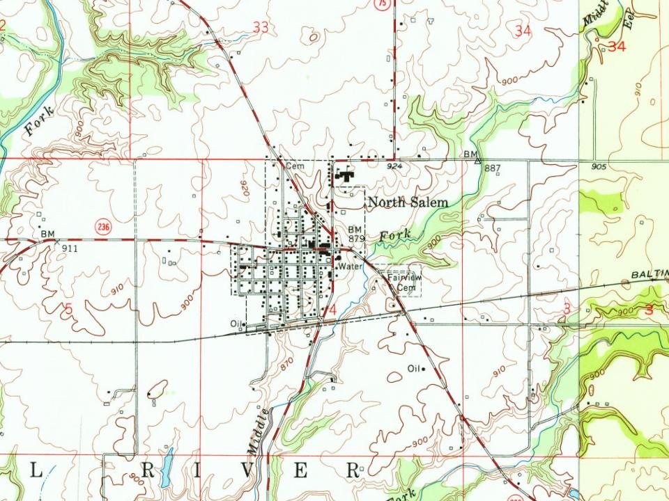
Peaked at 626 in 1960; 464 people lived here in 2020.
17 censuses, 1860–2020.
U.S. Census Bureau decennial counts, from the census table on North Salem’s Wikipedia page.
From the old history books
What they wrote about North Salem, 1885–1914
Passages that mention North Salem, cut from the printed page as they were published.
History of Hendricks County, Indiana, her people, industries and institutions1914Read the page →
Read the text
William Robert Davidson remained on the home farm until his marriage, after which he farmed his father's place for eight years and then, after three years' residence in North Salem, he bought ninety-two and a half acres east of his present farm, where he lived for thirteen years. He then sold this farm and moved four miles northeast of North Salem, after which he lived three years in North Salem, then bought his present farm of sixty-seven and a half acres, two miles northeast of North Salem. He has improved his farm in many ways and has brought it up to a high state of
Text read by machine from the scan; it may contain errors.
History of Hendricks County, Indiana1885 · page 578Read the page →
Read the text
After his return" from the war he worked in a saw-mill till 1868, when he came to North Salem, this county, and for fifteen years was prpprietor of the North Salem Saw-mill. In December, 1883, he began buying and shipping timber for an Indianapolis firm, and in February, 1885, he engaged in the mercantile business, having bought out Mr. W. J. K. P. Jones. He was married April 3, 1854, to Martha J. Gibson, and to them have been born five chil¬ dren — John F., Mollie, Thomas B., Annie B. and Mattie J. Mr.
Text read by machine from the scan; it may contain errors.
History of Hendricks County, Indiana, her people, industries and institutions1914Read the page →
Read the text
and opera house building in North Salem. Later he built the bank building, which contains the Masonic hall in the upper stories, and since then has built most of the business houses of North Salem. He has also built all of the brick school houses in Eel River township except two, and a large number of concrete bridges over Hendricks county. At the present time he manages the opera house and also owns and operates a cement tile factory at North Salem. As a contractor he is recognized as one of the most efficient and trustworthy artisans in }:he county, and his various buildings are a tribute to
Text read by machine from the scan; it may contain errors.
Scans and text from the Internet Archive. Books published in 1930 or earlier, which are in the public domain.
Timeline
North Salem, 1835 to 1960
Woven from the archive, old maps, post office records, the National Register and the people born here.
In 1835, according to Wikidata and Wikipedia’s history of the town. North Salem’s post office opened in 1839, and the census of 1860 counted 160 people here.
Founding dates: Wikidata, Wikipedia, the U.S. post office records of Blevins & Helbock (CC0) and the Census. Homes by year built: Census ACS 2020–24. National Register of Historic Places: National Park Service (list of May 22, 2026). Old photos, postcards and papers: Wikimedia Commons, the Library of Congress and other public archives, credited on each item’s page. Maps: U.S. Geological Survey historical topographic maps (via Esri) and Sanborn fire-insurance maps (Library of Congress). History text and census tables: Wikipedia (CC BY-SA 4.0). Places that used to be: USGS Geographic Names Information System (2021). How TownRatings grades history →
From Wikimedia Commons (2), Wikipedia, U.S. Geological Survey historical maps, U.S. Census counts (via Wikipedia), the US Post Offices dataset (Blevins & Helbock), the USGS Geographic Names Information System, Sanborn fire insurance maps (Library of Congress) and old county and town histories (Internet Archive). Archive images are copied here with their credits and licenses, shown on each photo’s page. Refreshed monthly.


 2020
 2020