New Harmony dates to 1814, and 39% of its homes were built before 1940
7 places in town are on the National Register, among them the New Harmony Historic District, a National Historic Landmark, and three historic districts with 230 buildings between them. Below: 9 old photos and papers, maps from 1888 on, and the census since 1850.
The town of Harmony was founded by Harmony Burton in 1814 under the leadership of German immigrant George Rapp (born Johann Georg Rapp). It was the second of three towns built by the pietist, communal religious group, known as Harmonists, Harmonites, or Rappites. The Harmonists settled in the Indiana Territory after leaving Harmony, Pennsylvania, where westward expansion, the area's rising population, jealous neighbors, and the increasing cost of land threatened the Society's desire for isolation.
Passages that mention New Harmony, cut from the printed page as they were published.
History and directory of Posey County [Indiana]1882 · page 228Read the page →
Read the text
Stafleth Robert, shoemaker, St. Phillip Stagrur Wm, cabinetmaker, Wadesville Staiger George, shoemaker, Blairsville Staley John, farmer Harmony twp, New Harmony Stallings Aaron, farmer, Lynn twp, New Harmony Stallings Alexander, farmer, Harmony twp, New Harmony Stallings Alonzo, farmer, Lynn twp, New Harmony Stallings Alvin, farmer, Bethel twp, New Harmony
Text read by machine from the scan; it may contain errors.
History and directory of Posey County [Indiana]1882 · page 77Read the page →
Read the text
Rapp, aided by his adopted son, Frederick Reichart, after a ten years' residence on the Wabash, determined to make another move; this time eastward instead of westward; and, through the agency of Mr. Richard Flower, of Albion, Illinois, the village of New Harmony and upwards of twenty thousand acres of land were sold, in 1825, for a hundred and fifty thousand dollars, to Robert Owen, of New Lanark, Scotland; a gentleman well-known as a philanthropist, and on account of his socialistic views.
Text read by machine from the scan; it may contain errors.
Scans and text from the Internet Archive. Books published in 1930 or earlier, which are in the public domain.
Timeline
New Harmony, 1814 to 1980
Woven from the archive, old maps, post office records, the National Register and the people born here.
Nothing in the archives for these yearsWeddings on Main Street, storms, parades, school pictures, the old store. If it’s in your family album, it belongs here.
Every edition of the U.S. Geological Survey’s map of New Harmony. Tap a year, or press play to watch the town change.
1903New Harmony sheet · 1:62,500
U.S. Geological Survey historical topographic maps (public domain), via Esri’s collection of the scans. The red ring marks the center of New Harmony.
Every building
New Harmony, building by building, 1888–1907
Fire insurance maps drew every building, what it was made of and what it was used for, so insurers could price the risk of fire. Pick a year, then a sheet.
In 1814, according to Wikidata and Wikipedia’s history of the town. New Harmony’s post office opened in 1816, and the census of 1850 counted 700 people here.
What is on the National Register in New Harmony?
7 listings: 4 buildings, 3 historic districts, the New Harmony Historic District, the Amon Clarence Thomas House and the New Harmony Historic District, with 230 contributing buildings, and 1 structure. 238 historic buildings in all.
Founding dates: Wikidata, Wikipedia, the U.S. post office records of Blevins & Helbock (CC0) and the Census. Homes by year built: Census ACS 2020–24. National Register of Historic Places: National Park Service (list of May 22, 2026). Old photos, postcards and papers: Wikimedia Commons, the Library of Congress and other public archives, credited on each item’s page. Maps: U.S. Geological Survey historical topographic maps (via Esri) and Sanborn fire-insurance maps (Library of Congress). History text and census tables: Wikipedia (CC BY-SA 4.0). Places that used to be: USGS Geographic Names Information System (2021). How TownRatings grades history →
From the Library of Congress (17), the National Register of Historic Places (8), Wikipedia, Wikidata and Wikipedia for famous people, U.S. Geological Survey historical maps, U.S. Census counts (via Wikipedia), the US Post Offices dataset (Blevins & Helbock), the USGS Geographic Names Information System, Sanborn fire insurance maps (Library of Congress) and old county and town histories (Internet Archive). Archive images are copied here with their credits and licenses, shown on each photo’s page. Refreshed monthly.


 ★ Landmark


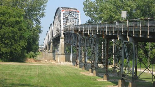


 1980
 1980
 Date?
 Date?
 Date?
 Date?
 Date?
 Date?
 2009
 2009
 2009
 2009
 2009
 2009
 2009
 2009


