Nappanee’s post office opened in 1875, and 23% of its homes were built before 1940
More historic than 80% of U.S. towns · #232 of 593 in Indiana. What drives it
7 places in town are on the National Register, among them three historic districts with 172 buildings between them. Below: 4 old photos and papers, maps from 1892 on, and the census since 1880.
Founding year: the first Nappanee post office (Blevins & Helbock, CC0).The full story ↓
History grade
What drives Nappanee’s History grade
On its age, its old homes and the National Register, Nappanee is more historic than 80% of U.S. towns, #232 of 593 in Indiana. Its National Register listings hold the grade up; its age pulls it down.
A−
HistoryA character grade: shown, never part of Nappanee’s overall grade.
Indiana towns list more on the Register than most of the country (a typical Indiana town has 7.9 per 10,000 residents, the U.S. 2.4), so Nappanee’s 258 sits above most of its state (90% of Indiana towns have fewer) while its 176 historic buildings outnumber those of 92% of U.S. towns.
How sure. Graded on any two of the three inputs instead, the letter would range from B to A. The pre-1940 share is a Census survey estimate (±6.5 points). The founding year is the first post office, not a stated founding date.
Founding year: the first post office (other dates in Quick answers). Homes: Census ACS 2020–24. National Register: National Park Service, May 2026 list; each listing counted once (boundary changes and added documentation belong to their listing), and a historic district counts its contributing buildings. How TownRatings grades history →
What stands out about Nappanee’s past
Read from the archive, the National Register and the record. The page puts what stands out first.
Fire insurance maps drew every building, what it was made of and what it was used for, so insurers could price the risk of fire. Pick a year, then a sheet.
Several hundred years ago, the indigenous Mound Builders built their settlements in an area to the north of the city's marshes. Pottawatomi arrived in the area from near Green Bay, Wisconsin in the 1700s, partially displacing the previous Miami inhabitants. The Pottawatomis had settlements on the Elkhart River at Elkhart, Goshen, and Waterford, and at Monoquet between Leesburg and Warsaw in what became Kosciusko County, Indiana. Thus, the Plymouth-Goshen Road near Nappanee probably follows the course of an old Indian Trail. The first European settlers came to the area in 1830, as various treaties and a process the Pottawatomi call the "Trail of Death" led to the relocation of Native Americans away from their traditional territories.
Passages that mention Nappanee, cut from the printed page as they were published.
A twentieth century history and biographical record of Elkhart County, Indiana1905 · page 125Read the page →
Read the text
panee was laid out, and with the help of the railroad grew rapidly and soon overmatched its ri\-al on the north. Locke could not hold its own even as an agricultural town, and its business interests soon were attracted to Nappanee or quietly passed away where they were. Twent)- five years ago Locke was still regarded as a commercial center of some importance. Now there are perhaps twenty-five or thirty people residing within the original limits of the village. At the date of this writing a small store building had just been erected by E. J. Pippenger. who
Text read by machine from the scan; it may contain errors.
History of Elkhart county, Indiana1881 · page 1046Read the page →
Read the text
But in lSTo-'6, after the town of jSTappanee was laid out, the eyes of a great many of the citizens of Locke were turned toward this new town to watch its probable growth. The town of Nappanee soon began to increase in population and business, and it being a railroad town, seemed likely to become a better business point than Locke; accordingly a great many of the citizens of Locke moved to Nappanee, some of them, indeed, moving their old houses with them.
Text read by machine from the scan; it may contain errors.
A standard history of Elkhart County, Indiana1916 · page 378Read the page →
Read the text
The Nappanee News, founded six years after the railroad town was laid out, has been owned since 1888 by Gordon N. Murray, of the family which has been so closely and prominently identified with the newspapers of the entire county. He is, therefore, a local pioneer, and speaks with special authority in regard to the founding and early progress of Nappanee. In a special edition of the News, published in 1905, Mr. Murray says: "There is considerable interest in the early history of Nappanee. The early settlers are here now,
Text read by machine from the scan; it may contain errors.
History of Elkhart county, Indiana1881 · page 1049Read the page →
Read the text
Mr. Mellinger started a saw-mill here in 1873, even before the town of Nappanee was beg'un, in company with Frank Meyers. They contini;ed as equal partners until 1876, when the former bought the latter out and continued alone until 1877, when he formed the partnership with the Coppes Brothers, already spoken of.
Text read by machine from the scan; it may contain errors.
Scans and text from the Internet Archive. Books published in 1930 or earlier, which are in the public domain.
Timeline
Nappanee, 1875 to 1958
Woven from the archive, old maps, post office records, the National Register and the people born here.
The Nappanee post office opened in 1875, the earliest record of the town by name (U.S. post office records).
How does Nappanee rank for history?
Nappanee is more historic than 80% of U.S. towns, #232 of 593 in Indiana. The History grade combines the town’s founding era, the share of homes built before 1940 and its National Register listings. It’s a character grade, so it isn’t part of the overall grade. How it works.
What is on the National Register in Nappanee?
7 listings: 4 buildings and 3 historic districts, the Downtown Nappanee Historic District, the Nappaness Eastside Historic District and the Stahly-Nissley-Kuhns Farm, with 172 contributing buildings. 176 historic buildings in all.
How old are the homes in Nappanee?
23% of Nappanee’s homes were built before 1940 (Census estimate, ±6.5 points), against a typical 14% for an Indiana town; the median home was built in 1984.
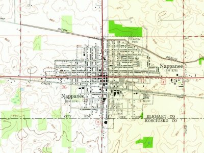
Founding dates: Wikidata, Wikipedia, the U.S. post office records of Blevins & Helbock (CC0) and the Census. Homes by year built: Census ACS 2020–24. National Register of Historic Places: National Park Service (list of May 22, 2026). Old photos, postcards and papers: Wikimedia Commons, the Library of Congress and other public archives, credited on each item’s page. Maps: U.S. Geological Survey historical topographic maps (via Esri) and Sanborn fire-insurance maps (Library of Congress). History text and census tables: Wikipedia (CC BY-SA 4.0). Places that used to be: USGS Geographic Names Information System (2021).
From Wikimedia Commons (10), the Library of Congress (6), the National Register of Historic Places (7), Wikipedia, Wikidata and Wikipedia for famous people, U.S. Geological Survey historical maps, U.S. Census counts (via Wikipedia), the US Post Offices dataset (Blevins & Helbock), the USGS Geographic Names Information System, Sanborn fire insurance maps (Library of Congress) and old county and town histories (Internet Archive). Archive images are copied here with their credits and licenses, shown on each photo’s page. Refreshed monthly.


 Date?
 Date?
 Date?
 Date?
 2024
 2016
 2016
 2016
 2016
 2016
 2016
 2014
 2013
 2012
 2011
 2011

