Guest, Sign inJoin

Post to Moores Hill

We’ll email a one-tap link to publish your post. No password, and nothing is public until you click it.
Already a member? Sign in
Moores Hill, IndianaPhoto: Chris Flook · CC BY-SA 4.0
–Not graded
History · Moores Hill

Moores Hill’s post office opened in 1823, and 28% of its homes were built before 1940

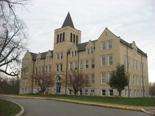
Its Register listings are the Carnegie Hall of Moores Hill College and the Moore's Hill United Methodist Church. Below: 2 old photos and papers, maps from 1916 on, and the census since 1850.

1823first post office
2on the National Register
28%homes built before 1940
2old photos & papers
2famous people
Quick answers

How Moores Hill began

When was Moores Hill founded?

1823

The Moores Hill post office opened in 1823, the earliest record of the town by name. Wikidata gives 1839.

First census: 206 in 18502020 census: 675203 years
Founding year: the first Moores Hill post office (Blevins & Helbock, CC0). Wikidata: 1839.The full story ↓

What stands out about Moores Hill’s past

Read from the archive, the National Register and the record. The page puts what stands out first.

★ What stands out · Help out

Start Moores Hill’s collection

The first neighbors to add old photos shape how Moores Hill’s history is told.

Decades since 1900 with photos
00s10s20s30s40s50s60s70s80s90s
0 of 10 decades. The empty ones are waiting for someone’s album.
People over time

Moores Hill, census by census

01002003004005006007001850190019502000617 in 1870Low: 285

Lost half of its people between 1870 and 1920, then more than doubled.

17 censuses, 1850–2020.

U.S. Census Bureau decennial counts, from the census table on Moores Hill’s Wikipedia page.

Timeline

Moores Hill, 1823 to 2020

Woven from the archive, old maps, post office records, the National Register and the people born here.

  1. 19th century
  2. 1823Post officeThe Moores Hill post office opens
  3. 1875In the archiveAtlas of Dearborn County, Indiana - to which is added a map of the state of Indiana, also…
  4. 1875Born hereHarry C. Canfield is born here
  5. 1883Born hereWalt Justis is born here
  6. 20th century
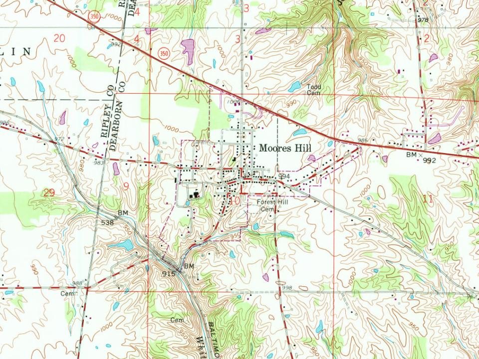
  7. 1958On the mapFirst mapped by the U.S. Geological Survey
  8. 21st century
  9. 2020CensusPopulation peaks at 675
The story

How Moores Hill came to be

From Wikipedia’s history of Moores Hill.

Read it all →

Platted in 1839 by Adam Moore and Andrew Stevens, it originally contained nine lots adjacent to Moore's gristmill. The community was originally known as Moores Mill, but postal authorities misspelled it Moores Hill, and the name stuck.

Many early settlers in the town were Methodist families from Delaware and the shore of Maryland. The first mercantile business was established by Samuel Herron.

Carnegie Hall of Moores Hill College and Moores Hill United Methodist Church are listed on the National Register of Historic Places.

Text from Wikipedia, licensed CC BY-SA 4.0.

From the old history books

What they wrote about Moores Hill in 1915

Passages that mention Moores Hill, cut from the printed page as they were published.

In 1818 Adam Moore, a Methodist preacher from Maryland, settled in the wilderness near the western boundary of Dearborn county. He was the first inhabitant of the town of Moores Hill — the seat of Moores Hill College. His son, John C. Moore, became a prominent business man in the early fifties. In …
History of Dearborn County Indiana1915 · page 472Read the page →
Read the text

In 1818 Adam Moore, a Methodist preacher from Maryland, settled in the wilderness near the western boundary of Dearborn county. He was the first inhabitant of the town of Moores Hill — the seat of Moores Hill College. His son, John C. Moore, became a prominent business man in the early fifties. In the spring of 1853 the Rev. W. W. Snyder, agent for Brookville College, called on J. C. Moore to solicit a subscription for that institution. This started him to thinking. Why not put the money in an institution at home, thus pro¬ viding a college education for our children ? Mr. Moore had the thought that

Text read by machine from the scan; it may contain errors.
Nine lots were originally laid out in the vicinity of what is commonly called Moores Hill, which were acknowledged by Spencer Davis, John Dashiell, and a Mr. Ablamoung, trustees of Wesley meeting house at Moores Hill, March 10, 1838. The original plat is said to have been laid out by Adam Digitized…
History of Dearborn County Indiana1915 · page 219Read the page →
Read the text

Nine lots were originally laid out in the vicinity of what is commonly called Moores Hill, which were acknowledged by Spencer Davis, John Dashiell, and a Mr. Ablamoung, trustees of Wesley meeting house at Moores Hill, March 10, 1838. The original plat is said to have been laid out by Adam Digitized by LjOOQLe

Text read by machine from the scan; it may contain errors.
Hill College, in the deparlnieut of science, and at the end of the fourth year, in 1893, he became assistant in the department of biology at the Johns Hopkins University, of Baltimore, and in 1894, he returned to Moores Hill, where he gave instruction in biology anfl geology, and in 1901 he was mad…
History of Dearborn county, Indiana1915Read the page →
Read the text

Hill College, in the deparlnieut of science, and at the end of the fourth year, in 1893, he became assistant in the department of biology at the Johns Hopkins University, of Baltimore, and in 1894, he returned to Moores Hill, where he gave instruction in biology anfl geology, and in 1901 he was made vicepresident of Moores Hill College, which office he held until November, 191 5.

Text read by machine from the scan; it may contain errors.

Scans and text from the Internet Archive. Books published in 1930 or earlier, which are in the public domain.

By decade

Moores Hill, decade by decade

One decade in the archive so far: the 1870s. Scroll each row; tap a photo for its story.

On the map

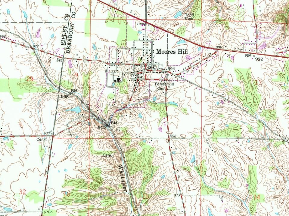
Moores Hill on the map, 1958 to 1992

Every edition of the U.S. Geological Survey’s map of Moores Hill. Tap a year, or press play to watch the town change.

Moores Hill on the 1958 USGS mapMoores Hill on the 1980 USGS mapMoores Hill on the 1992 USGS map1958Dillsboro sheet · 1:24,000

U.S. Geological Survey historical topographic maps (public domain), via Esri’s collection of the scans. The red ring marks the center of Moores Hill.

Every building

Moores Hill, building by building, 1916

Fire insurance maps drew every building, what it was made of and what it was used for, so insurers could price the risk of fire. Pick a sheet.

Moores Hill fire insurance map, 1916, sheet 11916Sheet 1 of 2

Sanborn Map Company, via the Library of Congress. Editions published in 1930 or earlier, which are in the public domain.

On the National Register

2 historic places in Moores Hill

The country’s official list of buildings and places worth saving.

places listed
2
National Historic Landmarks
0
none yet
historic buildings protected
2
each building in a district counts
first listed
1994
Carnegie Hall of Moores Hill College
Buildings

Architectural styles listings

Late 19th and 20th Century Revivals1
Late Gothic Revival1
Late Victorian1
Italianate1

National Park Service, National Register of Historic Places. Photos from Wikimedia Commons, credited on each place’s page.

Famous people

2 famous people were born in Moores Hill

Writers, athletes, leaders and more, ranked by how widely they’re known.

See all →

Questions about Moores Hill’s history

What year was Moores Hill founded?

The Moores Hill post office opened in 1823, the earliest record of the town by name (U.S. post office records). Wikidata gives 1839.

What is on the National Register in Moores Hill?

Two places: the Carnegie Hall of Moores Hill College (listed 1994) and the Moore's Hill United Methodist Church (1997).

Memory lane

What the archives can’t tell you, neighbors can.

Town Square →
Start a conversation
Sources

Where this page comes from

Founding dates: Wikidata, Wikipedia, the U.S. post office records of Blevins & Helbock (CC0) and the Census. Homes by year built: Census ACS 2020–24. National Register of Historic Places: National Park Service (list of May 22, 2026). Old photos, postcards and papers: Wikimedia Commons, the Library of Congress and other public archives, credited on each item’s page. Maps: U.S. Geological Survey historical topographic maps (via Esri) and Sanborn fire-insurance maps (Library of Congress). History text and census tables: Wikipedia (CC BY-SA 4.0). Places that used to be: USGS Geographic Names Information System (2021). How TownRatings grades history →

From Wikimedia Commons (5), the National Register of Historic Places (2), Wikipedia, Wikidata and Wikipedia for famous people, U.S. Geological Survey historical maps, U.S. Census counts (via Wikipedia), the US Post Offices dataset (Blevins & Helbock), the USGS Geographic Names Information System, Sanborn fire insurance maps (Library of Congress) and old county and town histories (Internet Archive). Archive images are copied here with their credits and licenses, shown on each photo’s page. Refreshed monthly.