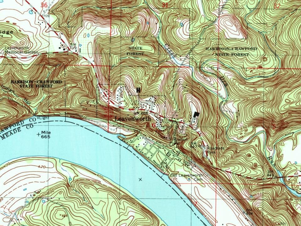
Leavenworth was laid out in 1818 in a horseshoe shaped bend of the Ohio River, directly under a large bluff called Mt. Eden. The bluff forms part of the Indiana Ridge and faces directly across the river toward Kentucky. "Old Leavenworth" (the original town, now practically abandoned) was almost completely wiped out by the huge 1937 Ohio River flood, as it was built directly on the floodplain.
The town was founded by Zebulon Leavenworth and his brother Seth, natives of Connecticut.
In 1824, a wood yard was established in the town to provide fuel to steamboats, and David Lyon had a boatbuilding industry here in 1830. The Whitcomb brickyard was also a flourishing industry.
Passages that mention Leavenworth, cut from the printed page as they were published.
Early history of Leavenworth city and county1906 · page 44Read the page →
Read the text
Although in these sketches, we are giving the early settle¬ ment of Leavenworth and incidents connected therewith, it may not be entirely out of place to give a slight notice of the first pub¬ lic sale of town lots at Atchison, a rival town of Leavenworth, as the three towns, Atchison, Kickapoo, and Leavenworth were sort of triplets, having sprung as I have previously said, from a common mother, old Mrs. Weston, of Platte county. Mo. While our triplet sister Kickapoo w^as alw^ays a little runty, for a number
Text read by machine from the scan; it may contain errors.
Scans and text from the Internet Archive. Books published in 1930 or earlier, which are in the public domain.
Timeline
Leavenworth, 1818 to 1946
Woven from the archive, old maps, post office records, the National Register and the people born here.
Every edition of the U.S. Geological Survey’s map of Leavenworth. Tap a year, or press play to watch the town change.
1946Leavenworth sheet · 1:24,000
U.S. Geological Survey historical topographic maps (public domain), via Esri’s collection of the scans. The red ring marks the center of Leavenworth.
Every building
Leavenworth, building by building, 1894–1899
Fire insurance maps drew every building, what it was made of and what it was used for, so insurers could price the risk of fire. Pick a year, then a sheet.
1894Sheet 1 of 1
Edition
Sheets
BrickWoodStone
Sanborn Map Company, via the Library of Congress. Editions published in 1930 or earlier, which are in the public domain.
Famous people
Famous people close to Leavenworth
Nobody well known was born in Leavenworth itself, so here are the best known from just nearby.
Founding dates: Wikidata, Wikipedia, the U.S. post office records of Blevins & Helbock (CC0) and the Census. Homes by year built: Census ACS 2020–24. National Register of Historic Places: National Park Service (list of May 22, 2026). Old photos, postcards and papers: Wikimedia Commons, the Library of Congress and other public archives, credited on each item’s page. Maps: U.S. Geological Survey historical topographic maps (via Esri) and Sanborn fire-insurance maps (Library of Congress). History text and census tables: Wikipedia (CC BY-SA 4.0). Places that used to be: USGS Geographic Names Information System (2021). How TownRatings grades history →
From Wikimedia Commons (2), Wikipedia, U.S. Geological Survey historical maps, U.S. Census counts (via Wikipedia), the US Post Offices dataset (Blevins & Helbock), the USGS Geographic Names Information System, Sanborn fire insurance maps (Library of Congress) and old county and town histories (Internet Archive). Archive images are copied here with their credits and licenses, shown on each photo’s page. Refreshed monthly.


 2020
 2016