Wikipedia doesn’t have a history of Jackson Township yet. The photos, dates and memories neighbors add here are how it gets written.
Jackson Township is one of eleven townships in Randolph County, Indiana, United States. As of the 2020 census, its population was 558 (down from 619 at 2010) and it contained 246 housing units.
Between the 2010 and 2020 censuses its population fell from 619 to 558 (-10%).
Intro from Wikipedia. Population: U.S. Census Bureau.
From the old history books
What they wrote about Jackson Township in 1882
Passages that mention Jackson Township, cut from the printed page as they were published.
HISTORY RANDOLPH COUNTY, INDIANA, Illustrations and Biographical Sketches WITH OF SOME OF ITS PROMINENT MEN AND PIONEERS, TO WHICH ARE APPENDED MAPS OF ITS SEVERAL TOWNSHIPS.1882Read the page →
Read the text
The Portland & Union Railroad, projected many years ago, was graded through Jackson Township, and New Pittsburg was laid out for a center of trade, but the railroad was not completed; the track was never made, and the road is simply a useless bank of earth, and Jackson Township and New Pittsburg as well is out in the cold.
Text read by machine from the scan; it may contain errors.
History of Randolph County, Indiana with illustrations and biographical sketches of some of its prominent men and pioneers1882Read the page →
Read the text
Jl would :,eeni from the above that in Jackson Township up to .April 12, 1S:!7, iiot quite four sections or about one thousand one hundred and forty acres of land had been entered, by about thirty-one persons, no entry being above 160 acres, and nearly all eiglities or forties, The great rush of settlement came in 1837 and 1838. The entries in Jackson Township were made by men of very moderate pecuniary ability. Economy and thrift have, however, become the means of furnishing to many in (ho
Text read by machine from the scan; it may contain errors.
HISTORY RANDOLPH COUNTY, INDIANA, Illustrations and Biographical Sketches WITH OF SOME OF ITS PROMINENT MEN AND PIONEERS, TO WHICH ARE APPENDED MAPS OF ITS SEVERAL TOWNSHIPS.1882Read the page →
Read the text
The first entry in Jackson Township was by John Abercrombie, October 16, 1816, southwest quarter Section 7, Town 21, Range 15. Jackson Township was not settled till long afterward.
Text read by machine from the scan; it may contain errors.
Scans and text from the Internet Archive. Books published in 1930 or earlier, which are in the public domain.
Timeline
Jackson Township, 1858 to 1960
Woven from the archive, old maps, post office records, the National Register and the people born here.
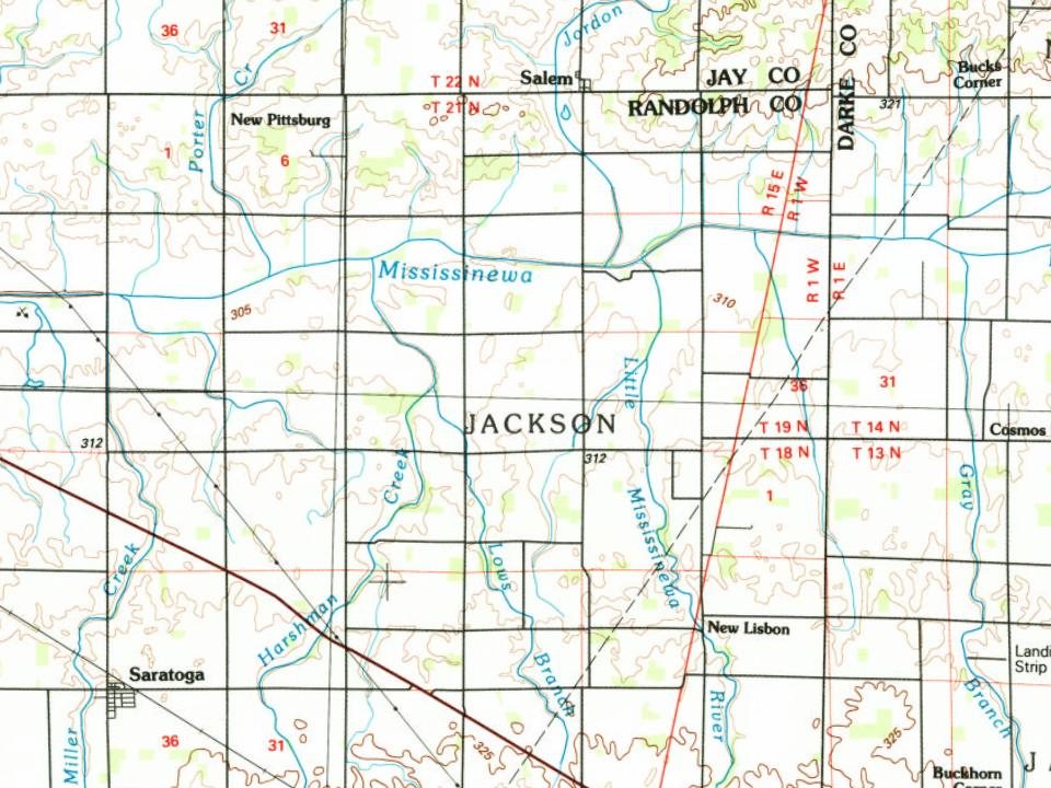
Every edition of the U.S. Geological Survey’s map of Jackson Township. Tap a year, or press play to watch the town change.
1960Cosmos sheet · 1:24,000
U.S. Geological Survey historical topographic maps (public domain), via Esri’s collection of the scans. The red ring marks the center of Jackson Township.
Places that used to be
Lost post offices, old corners and burying grounds
Another post office, New Pittsburg, opened and closed inside today’s town.
Hamlets and corners on the map
New LisbonNew Pittsburg
2cemeteries and burying grounds inside Jackson Township
Brick Memorial ParkHoover
US Post Offices dataset (Blevins & Helbock, CC0). Places and cemeteries from the USGS Geographic Names Information System (2021).
Stories next door
History across the town line
Each neighbor’s History grade, on the same three inputs.
Founding dates: Wikidata, Wikipedia, the U.S. post office records of Blevins & Helbock (CC0) and the Census. Homes by year built: Census ACS 2020–24. National Register of Historic Places: National Park Service (list of May 22, 2026). Old photos, postcards and papers: Wikimedia Commons, the Library of Congress and other public archives, credited on each item’s page. Maps: U.S. Geological Survey historical topographic maps (via Esri) and Sanborn fire-insurance maps (Library of Congress). History text and census tables: Wikipedia (CC BY-SA 4.0). Places that used to be: USGS Geographic Names Information System (2021). How TownRatings grades history →
From U.S. Geological Survey historical maps, the US Post Offices dataset (Blevins & Helbock), the USGS Geographic Names Information System and old county and town histories (Internet Archive). Archive images are copied here with their credits and licenses, shown on each photo’s page. Refreshed monthly.