Hobart’s post office opened in 1847, and 13% of its homes were built before 1940
More historic than 80% of U.S. towns · #230 of 593 in Indiana. What drives it
5 places in town are on the National Register, among them a historic district with 38 buildings. Below: 4 old photos and papers, maps from 1895 on, and the census since 1880.
The Hobart post office opened in 1847, the earliest record of the town by name. Wikidata gives 1889. Another post office, Ainsworth (1882), opened inside today’s city and later closed.
First census: 600 in 18802020 census: 29,752179 years
How historic is Hobart?
A−
More historic than 80% of U.S. towns, on its age, its old homes and the National Register.
Founding year: the first Hobart post office (Blevins & Helbock, CC0). Wikidata: 1889.The full story ↓
History grade
What drives Hobart’s History grade
On its age, its old homes and the National Register, Hobart is more historic than 80% of U.S. towns, #230 of 593 in Indiana. All 3 inputs are above most U.S. towns; its age ranks highest and its share of homes from before 1940 lowest.
A−
HistoryA character grade: shown, never part of Hobart’s overall grade.
Indiana towns list more on the Register than most of the country (a typical Indiana town has 7.9 per 10,000 residents, the U.S. 2.4), so Hobart’s 14.5 sits above most of its state (66% of Indiana towns have fewer) while its 43 historic buildings outnumber those of 84% of U.S. towns.
How sure. Graded on any two of the three inputs instead, the letter would range from B+ to A−. The pre-1940 share (±2.7 points) is firm at this size. The founding year is the first post office, not a stated founding date; Wikidata gives 1889.
Founding year: the first post office (other dates in Quick answers). Homes: Census ACS 2020–24. National Register: National Park Service, May 2026 list; each listing counted once (boundary changes and added documentation belong to their listing), and a historic district counts its contributing buildings. How TownRatings grades history →
What stands out about Hobart’s past
Read from the archive, the National Register and the record. The page puts what stands out first.
National Park Service, National Register of Historic Places. Photos from Wikimedia Commons, credited on each place’s page.
Every building
Hobart, building by building, 1895–1922
Fire insurance maps drew every building, what it was made of and what it was used for, so insurers could price the risk of fire. Pick a year, then a sheet.
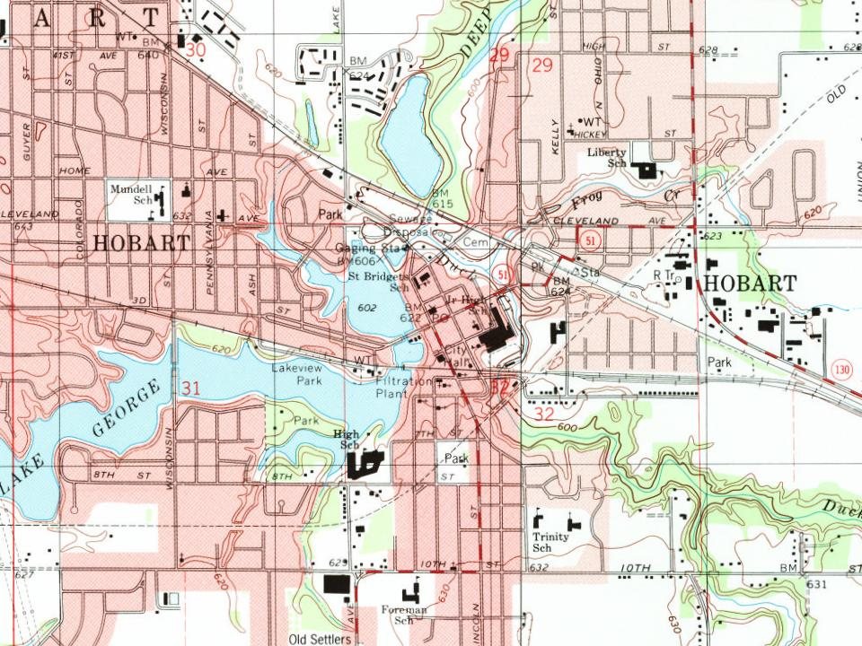
Hobart was platted in 1849. George Earle, an English immigrant, bought land from the Potawatomi Native American tribe, who built a dam on Deep River, creating Lake George. He named the settlement that later developed into Hobart, after his brother, Frederick Hobart Earle, who never left England. The first school of the city was built in 1878.
Hobart was incorporated as a town in 1889 and reincorporated as a city in 1921.
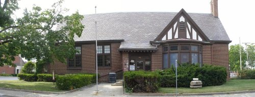
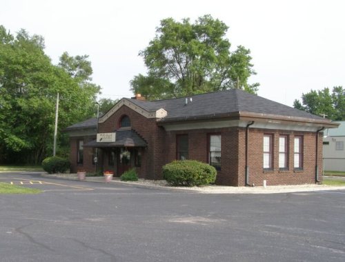
The First Unitarian Church of Hobart, Hobart Carnegie Library Hobart Commercial District, and Pennsylvania Railroad Station are listed in the National Register of Historic Places. The Lake George Commercial Historic District is noted locally. Hobart is also the site of several WPA projects, including a post office.
Passages that mention Hobart, cut from the printed page as they were published.
A standard history of Lake County, Indiana, and the Calumet region1915 · page 45Read the page →
Read the text
at what became the Town of Ilobart, which he platted in 1848, In 1854 he returned to Philadelphia, leaving his son, John Earle, who afterward became well known as a Chicago capitalist, to manage his interests in Lake County. The elder man did much for the Town of Hobart, although after 1854 he spent much of his time in his native town of Falmouth, England. A gentleman of varied abilities he certainly was ; for he was an artist of talents, and in 1858 presented Hobart with an art gallery comprising three hundred pictures which he had painted in
Text read by machine from the scan; it may contain errors.
A standard history of Lake County, Indiana, and the Calumet region1915 · page 184Read the page →
Read the text
followed the cheese factory, the houses increased in number and improved in appearance, and it secured an outlet both north and south by the construction of a substantial macadam road from Crown Point, through Ainsworth, Hobart and Lake Station to Lake Michigan. That thoroughfare is still of great benefit to Merrillville, although since 1903 it has enjoyed railroad connection over the Chicago, Cincinnati & Louisville Railroad.
Text read by machine from the scan; it may contain errors.
Scans and text from the Internet Archive. Books published in 1930 or earlier, which are in the public domain.
Timeline
Hobart, 1847 to 1997
Woven from the archive, old maps, post office records, the National Register and the people born here.
Nothing in the archives for these yearsWeddings on Main Street, storms, parades, school pictures, the old store. If it’s in your family album, it belongs here.
The Hobart post office opened in 1847, the earliest record of the town by name (U.S. post office records). Wikidata gives 1889.
How does Hobart rank for history?
Hobart is more historic than 80% of U.S. towns, #230 of 593 in Indiana. The History grade combines the town’s founding era, the share of homes built before 1940 and its National Register listings. It’s a character grade, so it isn’t part of the overall grade. How it works.
What is on the National Register in Hobart?
5 listings: 4 buildings, among them the Hobart Carnegie Library (listed 1982, the first), and 1 historic district, the Hobart Commercial District, with 38 contributing buildings. 43 historic buildings in all.
How old are the homes in Hobart?
13% of Hobart’s homes were built before 1940 (Census estimate, ±2.7 points), against a typical 14% for an Indiana town; the median home was built in 1971.
Founding dates: Wikidata, Wikipedia, the U.S. post office records of Blevins & Helbock (CC0) and the Census. Homes by year built: Census ACS 2020–24. National Register of Historic Places: National Park Service (list of May 22, 2026). Old photos, postcards and papers: Wikimedia Commons, the Library of Congress and other public archives, credited on each item’s page. Maps: U.S. Geological Survey historical topographic maps (via Esri) and Sanborn fire-insurance maps (Library of Congress). History text and census tables: Wikipedia (CC BY-SA 4.0). Places that used to be: USGS Geographic Names Information System (2021).
From Wikimedia Commons (13), the Library of Congress (4), the National Register of Historic Places (5), Wikipedia, Wikidata and Wikipedia for famous people, U.S. Geological Survey historical maps, U.S. Census counts (via Wikipedia), the US Post Offices dataset (Blevins & Helbock), the USGS Geographic Names Information System, Sanborn fire insurance maps (Library of Congress) and old county and town histories (Internet Archive). Archive images are copied here with their credits and licenses, shown on each photo’s page. Refreshed monthly.




 1909
 1909
 1909
 2007
 2007
 2007
 2006
 2006
 2006
 2006
 2006
 2006
 2006
 2006
 2006
 2006