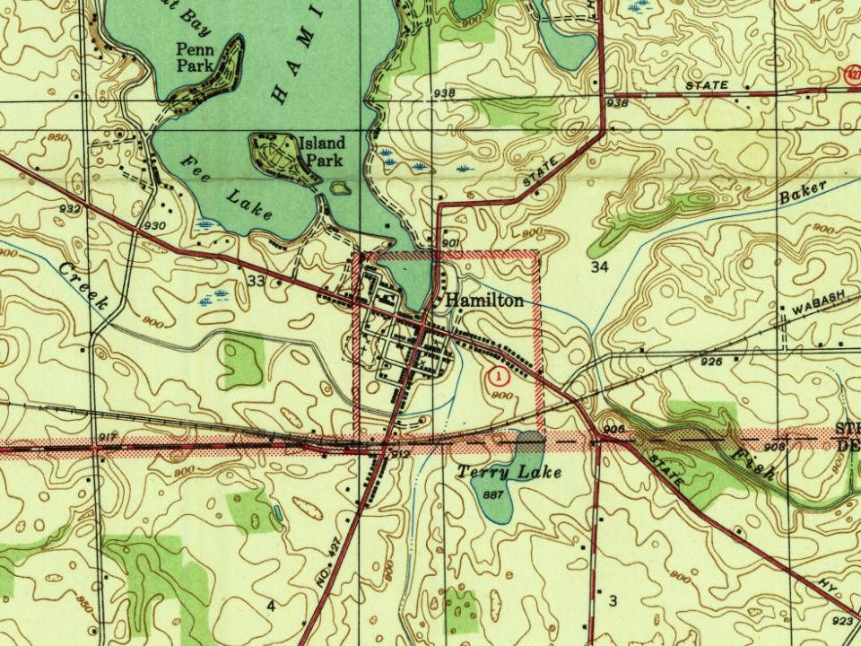
The Hamilton post office opened in 1844, the earliest record of the town by name. Another post office, Enterprise (1837), opened inside today’s town and later closed.
First census: 387 in 19202020 census: 1,529182 years
How historic is Hamilton?
B
More historic than 61% of U.S. towns, on its age, its old homes and the National Register.
Founding year: the first Hamilton post office (Blevins & Helbock, CC0).The full story ↓
History grade
What drives Hamilton’s History grade
On its age, its old homes and the National Register, Hamilton is more historic than 61% of U.S. towns. Its age holds the grade up; its National Register listings pull it down.
B
HistoryA character grade: shown, never part of Hamilton’s overall grade.
Indiana towns list more on the Register than most of the country (a typical Indiana town has 7.9 per 10,000 residents, the U.S. 2.4), so Hamilton’s 0.0 sits below most of its state (22% of Indiana towns have fewer) while its 0 listings outnumber those of 23% of U.S. towns.
How sure. Graded on any two of the three inputs instead, the letter would range from C+ to A−. The pre-1940 share is a Census survey estimate (±7.2 points). The founding year is the first post office, not a stated founding date.
Founding year: the first post office (other dates in Quick answers). Homes: Census ACS 2020–24. National Register: National Park Service, May 2026 list; each listing counted once (boundary changes and added documentation belong to their listing), and a historic district counts its contributing buildings. How TownRatings grades history →
What stands out about Hamilton’s past
Read from the archive, the National Register and the record. The page puts what stands out first.
In the late 1830s, the land that present-day Hamilton was built on was sold by the owner Niconar Munson to Dr. Samuel Tuttle, who was the first to plat the town. The original name of the town was "Enterprise". Dr. Tuttle went to New York shortly thereafter, where he met Fisher Howe, president of a syndicate of capitalists. Dr. Tuttle sold all but one-sixteenth of the plat to him for $15,000. In the spring of 1838, Howe sent Sidney Gambia, an agent, to Enterprise to sell goods and develop the settlement. However, Enterprise was heavily ladened with illness that year, to such an extent that it became known for it. To improve the settlement's reputation, the name was changed to Hamilton. Eventually the town was sold to Sidney Gambia for $1 (and for other terms), and the name was officially recorded as the Town of Hamilton in 1844.
Passages that mention Hamilton, cut from the printed page as they were published.
History of Hamilton and Clay counties, Nebraska / supervising editors George L. Burr, O.O. Buck1921 · page 453Read the page →
Read the text
the next winter to lobby during the legislature and was instrumental in having the law changed to read three-fifths of the votes east would relocate the county seat. In May the commissioners called a special election but another difficulty arose that had to be surmounted. The village of Hamilton was started and entered into competition with Aurora ; consequently the special election was called in Aurora having thirty majority over Hamilton; another election was called the following month and the majority was the same but in favor of Hamilton.
Text read by machine from the scan; it may contain errors.
History of Gallatin, Saline, Hamilton, Franklin and Williamson counties, Illinois, from the earliest time to the present1887 · page 255Read the page →
Read the text
ownership of the northwest quarter of Section 21, Township 6, Range 6, 160 acres, to John Townsend for $600. The third was made by William B. McLean, June 18, 1823, to the commisioners of Hamilton County, "for the use of the county commissioners of Hamilton County and their successors in office, of a certain tract or parcel of land, known and distinguished on a plat or map of the town of McLeansboro; said land being located, twenty acres of it, by the commissioners appointed by the General Assem-
Text read by machine from the scan; it may contain errors.
Scans and text from the Internet Archive. Books published in 1930 or earlier, which are in the public domain.
By decade
Hamilton, decade by decade
One decade in the archive so far: the 1900s. Scroll each row; tap a photo for its story.
Nothing in the archives for these yearsWeddings on Main Street, storms, parades, school pictures, the old store. If it’s in your family album, it belongs here.
Between 357 and 1,532 people in every census since 1920.
11 censuses, 1920–2020.
U.S. Census Bureau decennial counts, from the census table on Hamilton’s Wikipedia page.
Questions about Hamilton’s history
What year was Hamilton founded?
The Hamilton post office opened in 1844, the earliest record of the town by name (U.S. post office records).
How does Hamilton rank for history?
Hamilton is more historic than 61% of U.S. towns. The History grade combines the town’s founding era, the share of homes built before 1940 and its National Register listings. It’s a character grade, so it isn’t part of the overall grade. How it works.
How old are the homes in Hamilton?
21% of Hamilton’s homes were built before 1940 (Census estimate, ±7.2 points), against a typical 14% for an Indiana town; the median home was built in 1976.
Founding dates: Wikidata, Wikipedia, the U.S. post office records of Blevins & Helbock (CC0) and the Census. Homes by year built: Census ACS 2020–24. National Register of Historic Places: National Park Service (list of May 22, 2026). Old photos, postcards and papers: Wikimedia Commons, the Library of Congress and other public archives, credited on each item’s page. Maps: U.S. Geological Survey historical topographic maps (via Esri) and Sanborn fire-insurance maps (Library of Congress). History text and census tables: Wikipedia (CC BY-SA 4.0). Places that used to be: USGS Geographic Names Information System (2021).
From Wikimedia Commons (1), the Library of Congress (2), Wikipedia, Wikidata and Wikipedia for famous people, U.S. Geological Survey historical maps, U.S. Census counts (via Wikipedia), the US Post Offices dataset (Blevins & Helbock), the USGS Geographic Names Information System, Sanborn fire insurance maps (Library of Congress) and old county and town histories (Internet Archive). Archive images are copied here with their credits and licenses, shown on each photo’s page. Refreshed monthly.
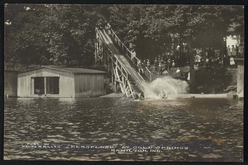



 1900
 2012