Fountain City dates to 1844, and 34% of its homes were built before 1940
2 places in town are on the National Register, among them the Levi Coffin House, a National Historic Landmark, and a historic district with 102 buildings. Below: maps from 1960 on and the census since 1880.
Fountain City was originally called New Garden, and under that name was laid out in 1818. New Garden became Newport in 1834, which was renamed Fountain City in 1878, named for its natural springs. It was incorporated as a town in 1844.
The Fountain City post office has been in operation since 1878.
The Levi Coffin House, home of Quaker abolitionist Levi Coffin and his wife Catherine, was an important stop on the Underground Railroad. Coffin was sometimes known as the "president" of the Underground Railroad. It is now operated as an Indiana State Historic Site.
Passages that mention Fountain City, cut from the printed page as they were published.
History of Wayne County, Indiana1884 · page 630Read the page →
Read the text
early residents have furnished additional particulars upon which are based the items which follow: George Shugart, whose son George, an old resident, now lives in Fountain City, settled in this county in 1810. He remained the first winter near Richmond, then took up and began improving land, a part of which is now included in the town of Fountain City. Indians were very numerous, and were frequent visitors at Shugart's cabin. During the war
Text read by machine from the scan; it may contain errors.
History of Wayne County, Indiana1884 · page 632Read the page →
Read the text
This thriving town of about 600 inhabitants was laid out in 1818, by Redden Chance and Solomon Thomas. It was at first known as New Garden, became Newport -in 1834, and Fountain City in 1878. A new name was found to be necessary to avoid confusion in mail matter, the postoffice having a different name from the town until the last change was made. During the past ten years the town has improved more and faster than in any other period of its history. The
Text read by machine from the scan; it may contain errors.
Scans and text from the Internet Archive. Books published in 1930 or earlier, which are in the public domain.
Timeline
Fountain City, 1824 to 1965
Woven from the archive, old maps, post office records, the National Register and the people born here.
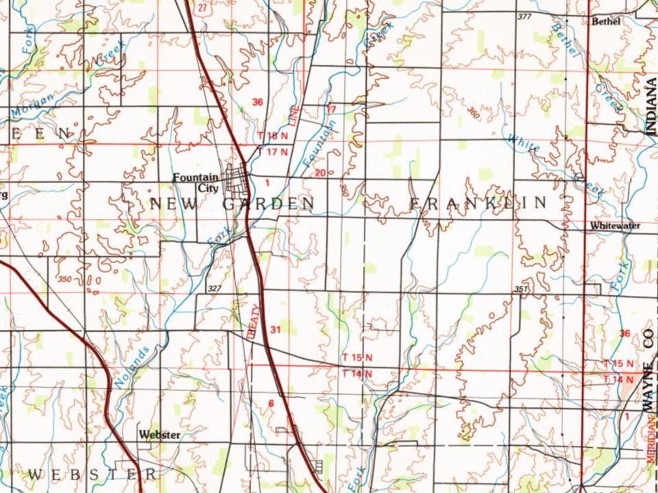
Every edition of the U.S. Geological Survey’s map of Fountain City. Tap a year, or press play to watch the town change.
1960Fountain City sheet · 1:24,000
U.S. Geological Survey historical topographic maps (public domain), via Esri’s collection of the scans. The red ring marks the center of Fountain City.
People over time
Fountain City, census by census
Between 375 and 852 people in every census since 1880.
15 censuses, 1880–2020.
U.S. Census Bureau decennial counts, from the census table on Fountain City’s Wikipedia page.
Places that used to be
Lost post offices and burying grounds
Fountain City’s post office has been open since 1878. Another post office, New Garden, opened and closed inside today’s town.
New Garden
1824–1878
Fountain City
1878–today
18201920today
1cemetery inside Fountain City
Willow Grove
US Post Offices dataset (Blevins & Helbock, CC0). Places and cemeteries from the USGS Geographic Names Information System (2021).
Questions about Fountain City’s history
What year was Fountain City founded?
In 1844, according to Wikipedia’s history of the town. Fountain City’s post office opened in 1824, and the census of 1880 counted 471 people here.
What is on the National Register in Fountain City?
Two places: the Levi Coffin House (listed 1966) and the Fountain City Historic District (2018).
Founding dates: Wikidata, Wikipedia, the U.S. post office records of Blevins & Helbock (CC0) and the Census. Homes by year built: Census ACS 2020–24. National Register of Historic Places: National Park Service (list of May 22, 2026). Old photos, postcards and papers: Wikimedia Commons, the Library of Congress and other public archives, credited on each item’s page. Maps: U.S. Geological Survey historical topographic maps (via Esri) and Sanborn fire-insurance maps (Library of Congress). History text and census tables: Wikipedia (CC BY-SA 4.0). Places that used to be: USGS Geographic Names Information System (2021). How TownRatings grades history →
From Wikidata (1), the National Register of Historic Places (2), Wikipedia, Wikidata and Wikipedia for famous people, U.S. Geological Survey historical maps, U.S. Census counts (via Wikipedia), the US Post Offices dataset (Blevins & Helbock), the USGS Geographic Names Information System and old county and town histories (Internet Archive). Archive images are copied here with their credits and licenses, shown on each photo’s page. Refreshed monthly.


 ★ Landmark