On its age, its old homes and the National Register, Fort Branch is more historic than 36% of U.S. towns, #448 of 593 in Indiana. Its share of homes from before 1940 holds the grade up; its National Register listings pull it down.
C+
HistoryA character grade: shown, never part of Fort Branch’s overall grade.
Indiana towns list more on the Register than most of the country (a typical Indiana town has 7.9 per 10,000 residents, the U.S. 2.4), so Fort Branch’s 0.0 sits below most of its state (22% of Indiana towns have fewer) while its 0 listings outnumber those of 23% of U.S. towns.
How sure. Graded on two of the three inputs, so a change in either one moves the letter more than it would with three. The pre-1940 share is a Census survey estimate (±5.3 points).
Founding year: our sources. Homes: Census ACS 2020–24. National Register: National Park Service, May 2026 list; each listing counted once (boundary changes and added documentation belong to their listing), and a historic district counts its contributing buildings. How TownRatings grades history →
What stands out about Fort Branch’s past
Read from the archive, the National Register and the record. The page puts what stands out first.
Fire insurance maps drew every building, what it was made of and what it was used for, so insurers could price the risk of fire. Pick a year, then a sheet.
1895Sheet 1 of 1
Edition
Sheets
BrickWoodStone
Sanborn Map Company, via the Library of Congress. Editions published in 1930 or earlier, which are in the public domain.
Fort Branch had its start in the year 1852 by the building of the railroad through that territory. The town was originally called LaGrange, for the original owner of the site, but as there was another post office of that same name in Indiana, the town was renamed in commemoration of an old fort.
On April 3, 1989, an F3 tornado passed through the town causing between 5 and 50 million dollars in damage.
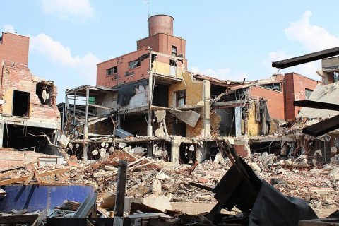
On February 28, 2017, an EF3 wedge tornado, originating in Crossville, Illinois, passed to the north of the town, destroying or heavily damaging several structures along Indiana 168.
Passages that mention Fort Branch, cut from the printed page as they were published.
History of Gibson County, Indiana1914 · page 353Read the page →
Read the text
Its history from the pioneer settlement to the year 1890 has been treated and fully covered in the township history of Johnson township, hence will not here be gone over, at any length. Suffice to say that it contains about fifty-one sections, with the town of Fort Branch about in its geographical center. It is surrounded liy the townships of Johnson. Montgomery, I'atoka, Center and Barton.
Text read by machine from the scan; it may contain errors.
History of Gibson County, Indiana1914 · page 348Read the page →
Read the text
In the spring of 1811 the people of the township became alarmed at the frequent outbreaks among the Indians, and accordingly a stockade of split logs was erected at the site of the present town of Fort Branch. The old fort has long since passed from view. Probably the first schools were taught in this township in 1810 by William Woods. The teacher boarded around, of course, and his pay consisted of a small sum from each family represented by a child in the school. James Johnson and James Curry were later teachers. Stephen Strickland, the
Text read by machine from the scan; it may contain errors.
Scans and text from the Internet Archive. Books published in 1930 or earlier, which are in the public domain.
Every edition of the U.S. Geological Survey’s map of Fort Branch. Tap a year, or press play to watch the town change.
1903Patoka sheet · 1:125,000
U.S. Geological Survey historical topographic maps (public domain), via Esri’s collection of the scans. The red ring marks the center of Fort Branch.
People over time
Fort Branch, census by census
Grew from 778 people in 1880 to 2,965 in 2020, 3 times over.
15 censuses, 1880–2020.
U.S. Census Bureau decennial counts, from the census table on Fort Branch’s Wikipedia page.
Questions about Fort Branch’s history
How does Fort Branch rank for history?
Fort Branch is more historic than 36% of U.S. towns, #448 of 593 in Indiana. The History grade combines the town’s founding era, the share of homes built before 1940 and its National Register listings. It’s a character grade, so it isn’t part of the overall grade. How it works.
How old are the homes in Fort Branch?
15% of Fort Branch’s homes were built before 1940 (Census estimate, ±5.3 points), against a typical 14% for an Indiana town; the median home was built in 1974.
Founding dates: Wikidata, Wikipedia, the U.S. post office records of Blevins & Helbock (CC0) and the Census. Homes by year built: Census ACS 2020–24. National Register of Historic Places: National Park Service (list of May 22, 2026). Old photos, postcards and papers: Wikimedia Commons, the Library of Congress and other public archives, credited on each item’s page. Maps: U.S. Geological Survey historical topographic maps (via Esri) and Sanborn fire-insurance maps (Library of Congress). History text and census tables: Wikipedia (CC BY-SA 4.0). Places that used to be: USGS Geographic Names Information System (2021).
From Wikimedia Commons (6), Wikipedia, U.S. Geological Survey historical maps, U.S. Census counts (via Wikipedia), the US Post Offices dataset (Blevins & Helbock), the USGS Geographic Names Information System, Sanborn fire insurance maps (Library of Congress) and old county and town histories (Internet Archive). Archive images are copied here with their credits and licenses, shown on each photo’s page. Refreshed monthly.


 2016
 2016
 2016
 2016
 2012
 2010

