Butler’s post office opened in 1840, and 37% of its homes were built before 1940
More historic than 95% of U.S. towns · #77 of 593 in Indiana. What drives it
1 place in town is on the National Register, among them a historic district with 30 buildings. Below: 1 old photo or paper, maps from 1958 on, and the census since 1880.
The Butler post office opened in 1840, the earliest record of the town by name. Two smaller post offices, Norristown (1853) and Jarvis (1859), opened inside today’s city and later closed.
First census: 1,056 in 18802020 census: 2,635186 years
How historic is Butler?
A
More historic than 95% of U.S. towns, on its age, its old homes and the National Register.
Founding year: the first Butler post office (Blevins & Helbock, CC0).The full story ↓
History grade
What drives Butler’s History grade
On its age, its old homes and the National Register, Butler is more historic than 95% of U.S. towns, #77 of 593 in Indiana. All 3 inputs are above most U.S. towns; its share of homes from before 1940 ranks highest and its age lowest.
A
HistoryA character grade: shown, never part of Butler’s overall grade.
Indiana towns list more on the Register than most of the country (a typical Indiana town has 7.9 per 10,000 residents, the U.S. 2.4), so Butler’s 113 sits above most of its state (82% of Indiana towns have fewer) while its 30 historic buildings outnumber those of 82% of U.S. towns.
How sure. Graded on any two of the three inputs instead, the letter would still be A. The pre-1940 share is a Census survey estimate (±7.9 points). The founding year is the first post office, not a stated founding date.
Founding year: the first post office (other dates in Quick answers). Homes: Census ACS 2020–24. National Register: National Park Service, May 2026 list; each listing counted once (boundary changes and added documentation belong to their listing), and a historic district counts its contributing buildings. How TownRatings grades history →
What stands out about Butler’s past
Read from the archive, the National Register and the record. The page puts what stands out first.
Butler was platted in 1856 when the railroad was extended to that point. It was likely named for David Butler, a pioneer. Butler was incorporated as a town in 1866, and as a city in 1903.
On July 23, 1966, Butler was one of the end points of a record-setting speed run by a New York Central RDC-3, M-497 Black Beetle, modified with a pair of jet engines, as the rail line between it and Stryker, Ohio, was both straight and flat. The car reached a speed of 183.68 mph (295.6 km/h), an American rail speed record that still stands today.
The Downtown Butler Historic District was added to the National Register of Historic Places in 2001.
Passages that mention Butler, cut from the printed page as they were published.
History of Butler County, Pennsylvania.1895 · page 307Read the page →
Read the text
The charter was issued May 2, 1817, by Governor Snyder, and Butler laid aside its swaddling clothes as soon as a new outfit could be procured. The section of the act relating to the incorporation of Butler is given herewith : Section 16. And be it further enacted, etc., That the town of Butler in the comity "1 Butler, shall be and the same is hereby erected into a borough, which shall be called the "Borough of Butler," and contained within the following metes and bounds: The original plat or draft of the town of Butler, beginning at a black oak on the bank of the mill dam; thence north seventy-eight degrees west seven perches; thence south fifty-two
Text read by machine from the scan; it may contain errors.
History of Butler County, Pennsylvania. With illustrations and biographical sketches of some of its prominent men and pioneers1883 · page 150Read the page →
Read the text
Butler was incorporated as a borough* by an act entitled, " An act to erect the town of Milton, in the county of Northumberland and the town of Butler, in tho county of Butler, into boroughs," which was read February 0. 1817, and passed February 20. The charter was issued j\Iay 2, 1817, by Gov. Simon Snyder, and signed by Nathaniel B. Boileau, Seci-etary.
Text read by machine from the scan; it may contain errors.
History of Butler County, Pennsylvania.1895 · page 334Read the page →
Read the text
On March 27, 1811, a call was laid on the table of Presbytery for Rev. James McConnell from the congregations of Butler and Deer Creek ; but for some reason the Butler branch of the charge did not prosecute this call, and it was returned to the congregations without being presented. At this meeting a paper was read '■ from the society of Butler praying for the dissolution of their connection with Deer Creek and the establishment of a connection with Slippery Rock." The Butler congregation with its new partner at once put forth an effort to obtain a pastoral settlement, and on April 10, 1811, a call was presented from Butler and
Text read by machine from the scan; it may contain errors.
History of Butler County, Pennsylvania. With illustrations and biographical sketches of some of its prominent men and pioneers1883 · page 36Read the page →
Read the text
At the same sessions, j)etitions were pre.sented for roa<ls from Butler to the Venango County line, "at or near the house of Thomas Barren:" from Butler to the Venango County line in the direction of Franklin; from Butler to the falls of the Slippery Rock; from Butler to Matthew Whites ( Whitestown); from Butler to the Beaver County line, nearly all of which were acted upon and "Viewei's ;i))]ioiuted at the same or suc-
Text read by machine from the scan; it may contain errors.
Scans and text from the Internet Archive. Books published in 1930 or earlier, which are in the public domain.
Timeline
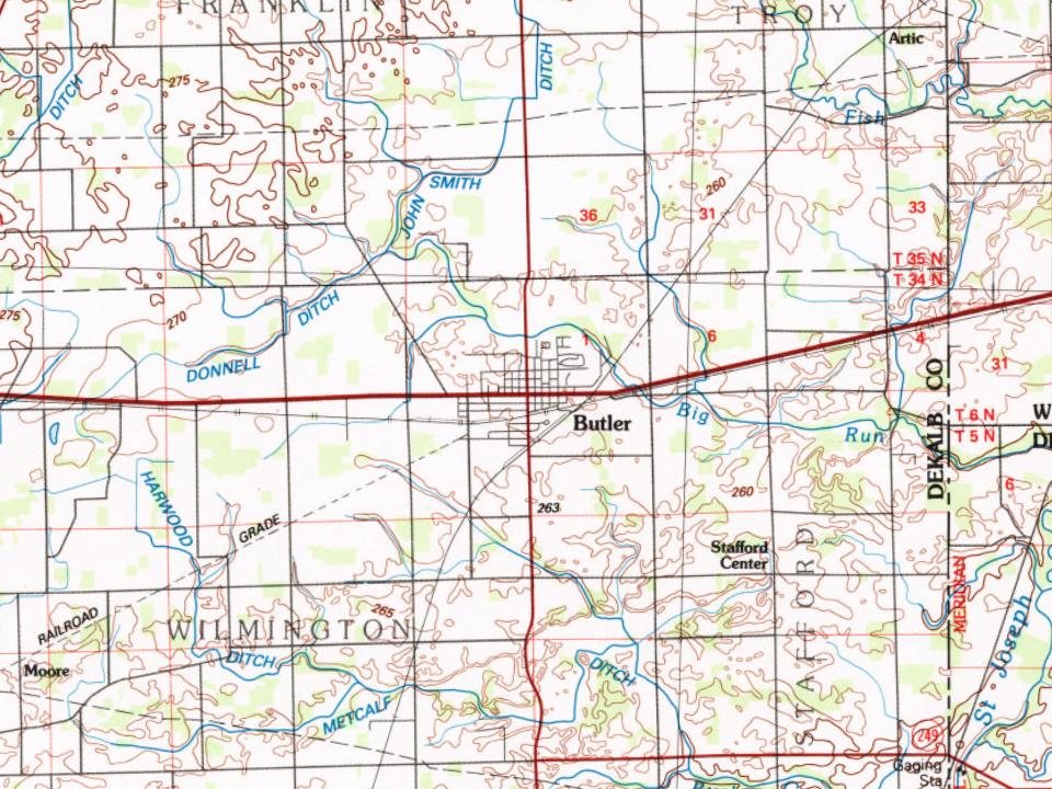
Butler, 1840 to 1958
Woven from the archive, old maps, post office records, the National Register and the people born here.
Between 1,056 and 2,725 people in every census since 1880.
15 censuses, 1880–2020.
U.S. Census Bureau decennial counts, from the census table on Butler’s Wikipedia page.
Questions about Butler’s history
What year was Butler founded?
The Butler post office opened in 1840, the earliest record of the town by name (U.S. post office records).
How does Butler rank for history?
Butler is more historic than 95% of U.S. towns, #77 of 593 in Indiana. The History grade combines the town’s founding era, the share of homes built before 1940 and its National Register listings. It’s a character grade, so it isn’t part of the overall grade. How it works.
What is on the National Register in Butler?
One place: the Downtown Butler Historic District (listed 2001).
How old are the homes in Butler?
37% of Butler’s homes were built before 1940 (Census estimate, ±7.9 points), against a typical 14% for an Indiana town; the median home was built in 1958.
Founding dates: Wikidata, Wikipedia, the U.S. post office records of Blevins & Helbock (CC0) and the Census. Homes by year built: Census ACS 2020–24. National Register of Historic Places: National Park Service (list of May 22, 2026). Old photos, postcards and papers: Wikimedia Commons, the Library of Congress and other public archives, credited on each item’s page. Maps: U.S. Geological Survey historical topographic maps (via Esri) and Sanborn fire-insurance maps (Library of Congress). History text and census tables: Wikipedia (CC BY-SA 4.0). Places that used to be: USGS Geographic Names Information System (2021).
From Wikimedia Commons (7), the Library of Congress (1), the National Register of Historic Places (1), Wikipedia, Wikidata and Wikipedia for famous people, U.S. Geological Survey historical maps, U.S. Census counts (via Wikipedia), the US Post Offices dataset (Blevins & Helbock), the USGS Geographic Names Information System and old county and town histories (Internet Archive). Archive images are copied here with their credits and licenses, shown on each photo’s page. Refreshed monthly.


 Date?
 2018
 2015
 2015
 2014
 2012
 2011
 2011