Brookville dates to 1808, and 24% of its homes were built before 1940
More historic than 95% of U.S. towns · #64 of 593 in Indiana. What drives it
3 places in town are on the National Register, among them a historic district with 660 buildings. Below: 2 old photos and papers, maps from 1883 on, and the census since 1850.
Founding year: Wikipedia. First post office: 1813.The full story ↓
History grade
What drives Brookville’s History grade
On its age, its old homes and the National Register, Brookville is more historic than 95% of U.S. towns, #64 of 593 in Indiana. All 3 inputs are above most U.S. towns; its National Register listings ranks highest and its age lowest.
A+
HistoryA character grade: shown, never part of Brookville’s overall grade.
Indiana towns list more on the Register than most of the country (a typical Indiana town has 7.9 per 10,000 residents, the U.S. 2.4), so Brookville’s 2,512 sits above most of its state (100% of Indiana towns have fewer) while its 664 historic buildings outnumber those of 98% of U.S. towns.
How sure. Graded on any two of the three inputs instead, the letter would range from A− to A+. The pre-1940 share is a Census survey estimate (±8.3 points). Two sources give 1808.
Founding year: Wikipedia (other dates in Quick answers). Homes: Census ACS 2020–24. National Register: National Park Service, May 2026 list; each listing counted once (boundary changes and added documentation belong to their listing), and a historic district counts its contributing buildings. How TownRatings grades history →
What stands out about Brookville’s past
Read from the archive, the National Register and the record. The page puts what stands out first.
Fire insurance maps drew every building, what it was made of and what it was used for, so insurers could price the risk of fire. Pick a year, then a sheet.
Brookville was platted in 1808 by Thomas Manwarring. The town derives its name from Brooks, the maiden name of a settler's mother. A post office has been in operation at Brookville since 1816.
Reports soon came in and confirmed what had been rumored earlier — that the greatest loss to property in the county was its bridges. The railroad bridges at Laurel and Brookville, the one over Salt creek, the one over Duck creek, at Metamora, the paper mill bridge at Brookville, the old Stringer Ford bridge, the "Old White bridge," and the new concrete bridge. Also the bridge at Xew Trenton, and those over the White Water and Big Cedar rivers in the southern portion of the county were swept from their abutments.
Text read by machine from the scan; it may contain errors.
About 1820 an agitation was begun for the erection of a house of worship and on October 7, 1821, Amos Butler deeded to Samuel Goodwin and William Sims, Jr., trustees of the meeting house in Brookville, and to their successors, for the use of the Alethodist society, lots 64 and 65, Amos Butler plat of the town of Brookville, upon which was erected the brick church in \vhich the Lutherans now worship. This, the first church erected in Broolcville, was dedicated some time in 1822, and was occupied by the Methodists until 1840.
Text read by machine from the scan; it may contain errors.
A pioneer history of Jefferson County, Pennsylvania and my first recollections of Brookville, Pennsylvania, 1840-1843,1898 · page 454Read the page →
Read the text
Roseville was celebrated for the early horse-racing. The other village in the township is Bellview (post-office, Stanton), about five miles south of Brookville. The taxables in 1828, 123; in 1835, 252 (this included the taxables in the borough of Brookville). The town and township held their elections together for a number of years, and the taxables were as- 454
Text read by machine from the scan; it may contain errors.
A pioneer history of Jefferson County, Pennsylvania and my first recollections of Brookville, Pennsylvania, 1840-1843,1898 · page 474Read the page →
Read the text
Brookville was the post-office for this settlement from 1833 to 1843. The pioneer court house of Forest County was built in Marienville, of hewed logs, and afterwards weather-boarded and painted white. The work was done by Bennett Dobbs. (See illustration.)
Text read by machine from the scan; it may contain errors.
Scans and text from the Internet Archive. Books published in 1930 or earlier, which are in the public domain.
Timeline
Brookville, 1808 to 1956
Woven from the archive, old maps, post office records, the National Register and the people born here.
Nothing in the archives for these yearsWeddings on Main Street, storms, parades, school pictures, the old store. If it’s in your family album, it belongs here.
Brookville’s post office has been open since 1813.
Hamlets and corners on the map
Stavetown
2cemeteries and burying grounds inside Brookville
Maple GroveSaint Michaels
US Post Offices dataset (Blevins & Helbock, CC0). Places and cemeteries from the USGS Geographic Names Information System (2021).
Questions about Brookville’s history
What year was Brookville founded?
In 1808, according to Wikipedia’s history of the town. Brookville’s post office opened in 1813, and the census of 1850 counted 1,177 people here.
How does Brookville rank for history?
Brookville is more historic than 95% of U.S. towns, #64 of 593 in Indiana. The History grade combines the town’s founding era, the share of homes built before 1940 and its National Register listings. It’s a character grade, so it isn’t part of the overall grade. How it works.
What is on the National Register in Brookville?
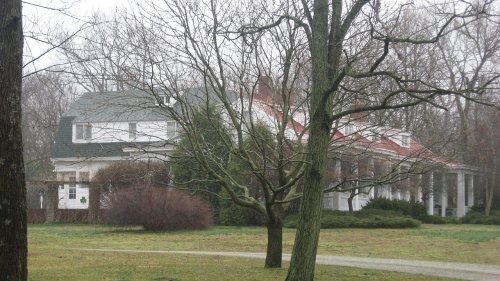
Three places: the Franklin County Seminary (listed 1974), the Brookville Historic District (1975) and the Hermitage, The (2004).
How old are the homes in Brookville?
24% of Brookville’s homes were built before 1940 (Census estimate, ±8.3 points), against a typical 14% for an Indiana town; the median home was built in 1967.
Founding dates: Wikidata, Wikipedia, the U.S. post office records of Blevins & Helbock (CC0) and the Census. Homes by year built: Census ACS 2020–24. National Register of Historic Places: National Park Service (list of May 22, 2026). Old photos, postcards and papers: Wikimedia Commons, the Library of Congress and other public archives, credited on each item’s page. Maps: U.S. Geological Survey historical topographic maps (via Esri) and Sanborn fire-insurance maps (Library of Congress). History text and census tables: Wikipedia (CC BY-SA 4.0). Places that used to be: USGS Geographic Names Information System (2021).
From Wikimedia Commons (5), the National Register of Historic Places (3), Wikipedia, Wikidata and Wikipedia for famous people, U.S. Geological Survey historical maps, U.S. Census counts (via Wikipedia), the US Post Offices dataset (Blevins & Helbock), the USGS Geographic Names Information System, Sanborn fire insurance maps (Library of Congress) and old county and town histories (Internet Archive). Archive images are copied here with their credits and licenses, shown on each photo’s page. Refreshed monthly.







 1894
 2023
 2023
 2005


