Brazil’s post office opened in 1844, and 23% of its homes were built before 1940
More historic than 94% of U.S. towns · #104 of 593 in Indiana. What drives it
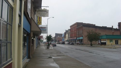
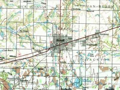
5 places in town are on the National Register, among them two historic districts with 255 buildings between them. Below: 3 old photos and papers, maps from 1883 on, and the census since 1850.
Founding year: the first Brazil post office (Blevins & Helbock, CC0). Wikidata: 1866.The full story ↓
History grade
What drives Brazil’s History grade
On its age, its old homes and the National Register, Brazil is more historic than 94% of U.S. towns, #104 of 593 in Indiana. All 3 inputs are above most U.S. towns; its National Register listings ranks highest and its age lowest.
A
HistoryA character grade: shown, never part of Brazil’s overall grade.
Indiana towns list more on the Register than most of the country (a typical Indiana town has 7.9 per 10,000 residents, the U.S. 2.4), so Brazil’s 332 sits above most of its state (92% of Indiana towns have fewer) while its 260 historic buildings outnumber those of 95% of U.S. towns.
How sure. Graded on any two of the three inputs instead, the letter would range from A− to A. The pre-1940 share is a Census survey estimate (±5.6 points). The founding year is the first post office, not a stated founding date; Wikidata gives 1866.
Founding year: the first post office (other dates in Quick answers). Homes: Census ACS 2020–24. National Register: National Park Service, May 2026 list; each listing counted once (boundary changes and added documentation belong to their listing), and a historic district counts its contributing buildings. How TownRatings grades history →
What stands out about Brazil’s past
Read from the archive, the National Register and the record. The page puts what stands out first.
Fire insurance maps drew every building, what it was made of and what it was used for, so insurers could price the risk of fire. Pick a year, then a sheet.
In the 1840s, the owners of the farmland that would later become the city of Brazil decided to name their farm after the country of Brazil. The city was founded in 1866. As of 2024, Brazil is part of the Terre Haute Metropolitan Statistical Area. Clay County, formed in 1825, originally had Bowling Green as its county seat. The county seat was relocated to Brazil in 1876 following the city's development.
The Chafariz dos Contos Fountain (from "contos de réis" a former Brazilian currency) was given to the city by the country of Brazil as a symbol of friendship in 1956. It is a replica of the original fountain located in Ouro Preto, State of Minas Gerais, Brazil, built in 1745.
Passages that mention Brazil, cut from the printed page as they were published.
A History of Clay County Indiana (Volume 2)1909 · page 497Read the page →
Read the text
South Railroad, doing four thousand dollars' worth of work on the road, at the end of which time the company failed and Mr. Myers thus lost all of his time and money. He next took a contract for grading Main street in the city of Brazil, and later did contract work in Parke county, Indiana, on the North & South Railroad, removing to that county in 1886. Later he returned to Brazil and took a railroad contract to grade and clear five acres of land. On the expiration of the period devoted to that work he removed to Minnesota, where he did contract work for
Text read by machine from the scan; it may contain errors.
A History of Clay County Indiana (Volume 2)1909 · page 207Read the page →
Read the text
There was only one railroad in the state when he came to Indiana and he helped to hew the timbers for the first depot built in Brazil, it being the property of the Terre Haute & Indianapolis Railroad, now the Vandalia Railroad. Mr. Sampson has paid taxes in this state for the past fifty-six years and has borne his full share in the work of development and progress, especially in agricultural lines. He has always rejoiced in what the county has accomplished, and his influence has ever been on the side of material, intellectual, moral and social progress.
Text read by machine from the scan; it may contain errors.
Scans and text from the Internet Archive. Books published in 1930 or earlier, which are in the public domain.
Timeline
Brazil, 1844 to 1986
Woven from the archive, old maps, post office records, the National Register and the people born here.
Nothing in the archives for these yearsWeddings on Main Street, storms, parades, school pictures, the old store. If it’s in your family album, it belongs here.
The Brazil post office opened in 1844, the earliest record of the town by name (U.S. post office records). Wikidata gives 1866.
How does Brazil rank for history?
Brazil is more historic than 94% of U.S. towns, #104 of 593 in Indiana. The History grade combines the town’s founding era, the share of homes built before 1940 and its National Register listings. It’s a character grade, so it isn’t part of the overall grade. How it works.
What is on the National Register in Brazil?
5 listings: 3 buildings, among them the US Post Office-Brazil (listed 1994, the first), and 2 historic districts, the Brazil Downtown Historic District and the Meridian-Forest Historic District, with 255 contributing buildings. 260 historic buildings in all.
How old are the homes in Brazil?
23% of Brazil’s homes were built before 1940 (Census estimate, ±5.6 points), against a typical 14% for an Indiana town; the median home was built in 1962.
Founding dates: Wikidata, Wikipedia, the U.S. post office records of Blevins & Helbock (CC0) and the Census. Homes by year built: Census ACS 2020–24. National Register of Historic Places: National Park Service (list of May 22, 2026). Old photos, postcards and papers: Wikimedia Commons, the Library of Congress and other public archives, credited on each item’s page. Maps: U.S. Geological Survey historical topographic maps (via Esri) and Sanborn fire-insurance maps (Library of Congress). History text and census tables: Wikipedia (CC BY-SA 4.0). Places that used to be: USGS Geographic Names Information System (2021).
From Wikimedia Commons (5), Wikidata (1), the National Register of Historic Places (5), Wikipedia, Wikidata and Wikipedia for famous people, U.S. Geological Survey historical maps, U.S. Census counts (via Wikipedia), the US Post Offices dataset (Blevins & Helbock), the USGS Geographic Names Information System, Sanborn fire insurance maps (Library of Congress) and old county and town histories (Internet Archive). Archive images are copied here with their credits and licenses, shown on each photo’s page. Refreshed monthly.






 2005
 2005

