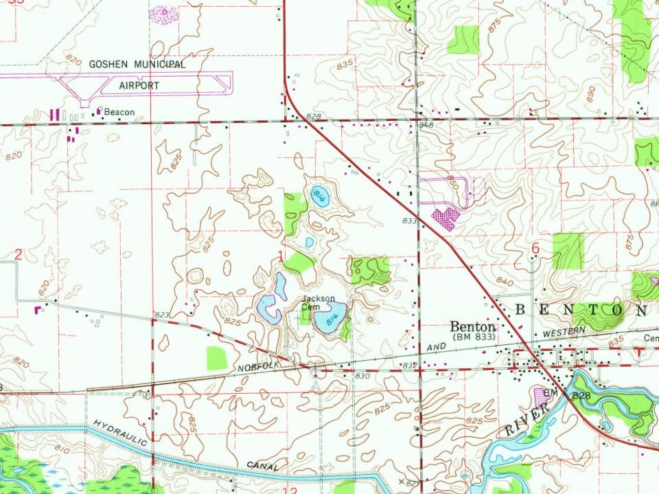
Benton was platted in 1832. It was named in honor of politician Thomas Hart Benton.
The railroad was built through Benton in 1892. A post office was established at Benton in 1835, and remained in operation until it was discontinued in 1963.
Passages that mention Benton, cut from the printed page as they were published.
Counties of Warren, Benton, Jasper and Newton, Indiana1883 · page 305Read the page →
Read the text
The first town laid out in Benton County was the town of Oxford, situated on the south half of the southeast quarter of Section 18, and the north half of the nortlieast quarter of Section 19, in Township 24, of Range 7.
Text read by machine from the scan; it may contain errors.
History of Benton Harbor and tales of village days. A combination of local historic events, interwoven with anecdotes of the times when Benton Harbor was a village. Together with a compilation of other records1915Read the page →
Read the text
Mr. J. E. Miller, in his reminiscence, which is published in this book, says it was voted in 1866 to change the name to Benton Harbor because it was the most important town in the county and township of Benton.
Text read by machine from the scan; it may contain errors.
History of Benton Harbor and tales of village days. A combination of local historic events, interwoven with anecdotes of the times when Benton Harbor was a village. Together with a compilation of other records1915Read the page →
Read the text
It was after a while voted to change the name to Benton Harbor, it being the chief town in the county and township of Benton.
Text read by machine from the scan; it may contain errors.
Counties of Warren, Benton, Jasper and Newton, Indiana1883 · page 276Read the page →
Read the text
The first railroad projected in Benton County was called the La Favette, Oxford & Bloomington Railroad. The Board of Commissioners, at their March session, 1S68, undertook and agreed to make up to the company any delin(|uency, not exceeding $10,000, that the company might not be able to collect of $!50,000 that the citizens of Benton County luursubscribed to aid in the construction of the road, which was to run from La Fayette, in Tippe-
Text read by machine from the scan; it may contain errors.
Scans and text from the Internet Archive. Books published in 1930 or earlier, which are in the public domain.
By decade
No old photos in the archives yet
Weddings on Main Street, storms, parades, school pictures, the old store. If it’s in your family album, it belongs here.
Be the first to add onePhotograph a print flat, in daylight, no flash.
Founding dates: Wikidata, Wikipedia, the U.S. post office records of Blevins & Helbock (CC0) and the Census. Homes by year built: Census ACS 2020–24. National Register of Historic Places: National Park Service (list of May 22, 2026). Old photos, postcards and papers: Wikimedia Commons, the Library of Congress and other public archives, credited on each item’s page. Maps: U.S. Geological Survey historical topographic maps (via Esri) and Sanborn fire-insurance maps (Library of Congress). History text and census tables: Wikipedia (CC BY-SA 4.0). Places that used to be: USGS Geographic Names Information System (2021). How TownRatings grades history →
From Wikipedia, U.S. Geological Survey historical maps and old county and town histories (Internet Archive). Archive images are copied here with their credits and licenses, shown on each photo’s page. Refreshed monthly.