Auburn’s post office opened in 1839, and 23% of its homes were built before 1940
More historic than 89% of U.S. towns · #154 of 593 in Indiana. What drives it
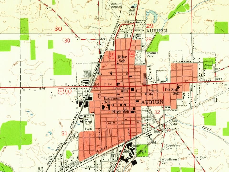
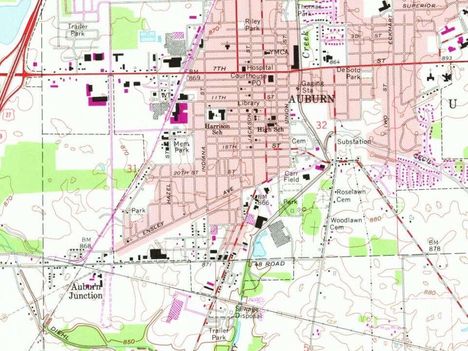
4 places in town are on the National Register, among them the Auburn Cord Duesenberg Automobile Facility, a National Historic Landmark, and a historic district with 52 buildings. Below: 6 old photos and papers, maps from 1957 on, and the census since 1850.
The Auburn post office opened in 1839, the earliest record of the town by name. Another post office, Auburn Junction (1884), opened inside today’s city and later closed.
First census: 260 in 18502020 census: 13,412187 years
How historic is Auburn?
A
More historic than 89% of U.S. towns, on its age, its old homes and the National Register.
Founding year: the first Auburn post office (Blevins & Helbock, CC0).The full story ↓
History grade
What drives Auburn’s History grade
On its age, its old homes and the National Register, Auburn is more historic than 89% of U.S. towns, #154 of 593 in Indiana. All 3 inputs are above most U.S. towns; its National Register listings ranks highest and its age lowest.
A
HistoryA character grade: shown, never part of Auburn’s overall grade.
Indiana towns list more on the Register than most of the country (a typical Indiana town has 7.9 per 10,000 residents, the U.S. 2.4), so Auburn’s 40.5 sits above most of its state (73% of Indiana towns have fewer) while its 55 historic buildings outnumber those of 86% of U.S. towns.
How sure. Graded on any two of the three inputs instead, the letter would range from A− to A. The pre-1940 share is a Census survey estimate (±4.4 points). The founding year is the first post office, not a stated founding date.
Founding year: the first post office (other dates in Quick answers). Homes: Census ACS 2020–24. National Register: National Park Service, May 2026 list; each listing counted once (boundary changes and added documentation belong to their listing), and a historic district counts its contributing buildings. How TownRatings grades history →
What stands out about Auburn’s past
Read from the archive, the National Register and the record. The page puts what stands out first.
Auburn's site on Cedar Creek was chosen by Wesley Park and John Badlam Howe at the intersection of two major trails, Goshen-Defiance Road and Coldwater Road, and next to the land of John Houlton. The name for the community likely came from "The Deserted Village" by Oliver Goldsmith, that begins "Sweet Auburn! Loveliest village of the plain." The plat of the Village of Auburn is dated April 21, 1836, but it was held by Howe and not recorded until March 12, 1879. John Drury purchased the first lot (Lot 73) for $25.00 on September 5, 1837. The first store was built at Park's corners by Thomas Freeman, applying for a license on March 5, 1838, and bringing supplies by horseback from Fort Wayne. Daniel Altenburg, Levi Walsworth, the Sherlock family, Samuel Sprott, David Weave, David Shoemaker, Henry Curtis, Lyman Childsey, James Cosper, and David Cosper were among the early residents.
Passages that mention Auburn, cut from the printed page as they were published.
The Lewiston and Auburn directory, containing the names of the inhabitants, their occupation and places of business, &c., the officers of the various societies, together with a history of Lewiston and Auburn1864Read the page →
Read the text
Academy, from main to railroad Chase, from maia to hii2,h Court, from bridge to Auburn heights Court, Pleasant plains, from court to turner road Drummond, from main to railroad Elm, from main to railroad Farmington road, from pleasant on the river High, from academy to court
Text read by machine from the scan; it may contain errors.
Scans and text from the Internet Archive. Books published in 1930 or earlier, which are in the public domain.
By decade
Auburn, decade by decade
2 decades in the archive, from the 1910s to the 1920s. Scroll each row; tap a photo for its story.
Nothing in the archives for these yearsWeddings on Main Street, storms, parades, school pictures, the old store. If it’s in your family album, it belongs here.
The Auburn post office opened in 1839, the earliest record of the town by name (U.S. post office records).
How does Auburn rank for history?
Auburn is more historic than 89% of U.S. towns, #154 of 593 in Indiana. The History grade combines the town’s founding era, the share of homes built before 1940 and its National Register listings. It’s a character grade, so it isn’t part of the overall grade. How it works.
What is on the National Register in Auburn?
4 listings: 3 buildings, among them the Auburn Cord Duesenberg Automobile Facility (a National Historic Landmark since 2005), and 1 historic district, the Downtown Auburn Historic District, with 52 contributing buildings. 55 historic buildings in all.
How old are the homes in Auburn?
23% of Auburn’s homes were built before 1940 (Census estimate, ±4.4 points), against a typical 14% for an Indiana town; the median home was built in 1980.
Founding dates: Wikidata, Wikipedia, the U.S. post office records of Blevins & Helbock (CC0) and the Census. Homes by year built: Census ACS 2020–24. National Register of Historic Places: National Park Service (list of May 22, 2026). Old photos, postcards and papers: Wikimedia Commons, the Library of Congress and other public archives, credited on each item’s page. Maps: U.S. Geological Survey historical topographic maps (via Esri) and Sanborn fire-insurance maps (Library of Congress). History text and census tables: Wikipedia (CC BY-SA 4.0). Places that used to be: USGS Geographic Names Information System (2021).
From Wikimedia Commons (8), the Library of Congress (21), the National Register of Historic Places (4), Wikipedia, Wikidata and Wikipedia for famous people, U.S. Geological Survey historical maps, U.S. Census counts (via Wikipedia), the US Post Offices dataset (Blevins & Helbock), the USGS Geographic Names Information System and old county and town histories (Internet Archive). Archive images are copied here with their credits and licenses, shown on each photo’s page. Refreshed monthly.


 ★ Landmark



 1918
 1918
 1918
 1918
 2016
 2016
 2016
 2016
 2016
 2016
 2016
 2016
 2016
 2016
 2016
 2016
 2016
 2016
 2016
 2016
 2016
 2016
 2016
 2016
 2016
 2013
 2003