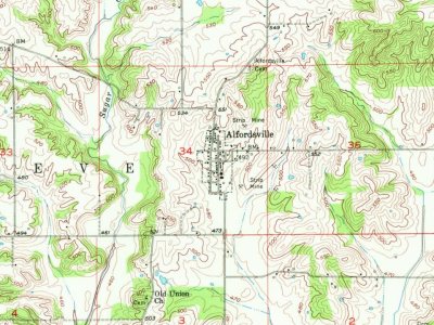
Most of Alfordsville was built recently: 6% of its homes predate 1940 and the median home dates from 1990. Below: maps from 1956 on and the census since 1880.
Passages that mention Alfordsville, cut from the printed page as they were published.
History of Knox and Daviess County, Indiana1886 · page 710Read the page →
Read the text
Alfordsville, in Reece Township, is the principal village in the southeastern portion of the county. It was laid off on June 3, 1845, by Isaac Harris. An attempt was made to incorporate it a few years ago, but failed for some reason. The original plat of the place shows sixty-four lots, but to these an addition of eight lots was made by Joseph A. McCord in 1867. The first settlers of the vicinity were James Alford, James P. Gilly and James Allen. These families came from North Carolina about the year
Text read by machine from the scan; it may contain errors.
History of Knox and Daviess County, Indiana1886 · page 877Read the page →
Read the text
was a soldier in the war of the Revolution, and was one hundred years old at the time of his death. Mr. Horrall rented land for some years after his marriage, and after living in various parts of the county finally settled in Alfordsville, where he engaged in managing a flouring-mill. He owns eighty acres of land and some valuable town property in Alfordsville.
Text read by machine from the scan; it may contain errors.
Scans and text from the Internet Archive. Books published in 1930 or earlier, which are in the public domain.
Founding dates: Wikidata, Wikipedia, the U.S. post office records of Blevins & Helbock (CC0) and the Census. Homes by year built: Census ACS 2020–24. National Register of Historic Places: National Park Service (list of May 22, 2026). Old photos, postcards and papers: Wikimedia Commons, the Library of Congress and other public archives, credited on each item’s page. Maps: U.S. Geological Survey historical topographic maps (via Esri) and Sanborn fire-insurance maps (Library of Congress). History text and census tables: Wikipedia (CC BY-SA 4.0). Places that used to be: USGS Geographic Names Information System (2021). How TownRatings grades history →
From Wikimedia Commons (5), Wikipedia, U.S. Geological Survey historical maps, U.S. Census counts (via Wikipedia), the US Post Offices dataset (Blevins & Helbock), the USGS Geographic Names Information System and old county and town histories (Internet Archive). Archive images are copied here with their credits and licenses, shown on each photo’s page. Refreshed monthly.



 2018
 2018
 2018
 2018
 2018

