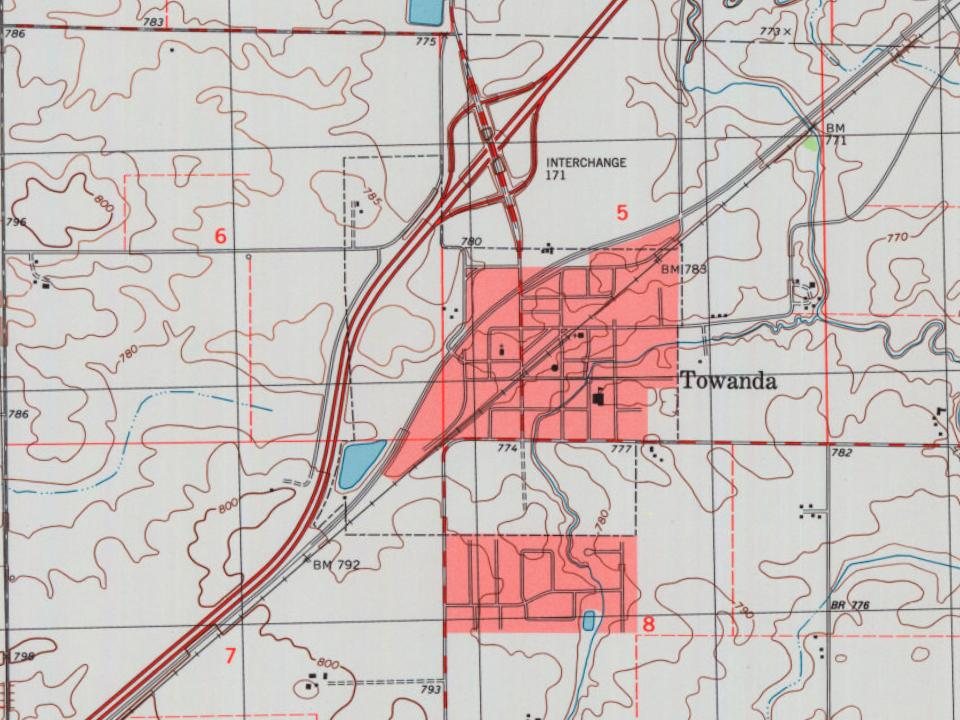
The village was named for Towanda in Bradford County, Pennsylvania. The name means "burial ground" in Nanticoke, an Algonquian language. The land on which Towanda stands was first entered by Charles Badeau who had graduated from Wesleyan University, Middletown, Connecticut, in 1840, and was employed as the assistant to the chief engineer of what was then the Alton and Springfield Railroad (now part of the Union Pacific system). Because in Illinois at that time it was illegal for railroads or their officials to establish new towns, much of the land was then transferred to two McLean County real estate developers, Jesse W. Fell (1808 – 1887) and Charles W. Holder (1819 - 1900). These two men laid out the town of Towanda and filed the plat on December 7, 1854.
Passages that mention Towanda, cut from the printed page as they were published.
History of McLean County, Illinois1924 · page 118Read the page →
Read the text
W. C. Orendorff performed the wedding service. The postoffice of the township was at the home of William D. Moore, on the site of the present town of Towanda. The first preacher was John Dunham at Smith's Grove in 1832. Rev. Ebenezer Rhodes visited this section in his rounds. There are now Methodist, Presbyterian, Baptist and Catholic churches in the township.
Text read by machine from the scan; it may contain errors.
The History of McLean County, Illinois1879 · page 699Read the page →
Read the text
Two and a half miles northeast of the village of Towanda, but within the limits of Money Creek Township, there was found, one morning in October, 1876, the body of a man, in the field of James Donohue, about forty rods from the railroad. The body was first discovered by Mrs. Strode. She thought it was a " tramp " asleep, and soreported the matter at home. The boys went out and found the man dead, lying on his face. They reported, and immediately sent for Coroner Hendricks. Dr. Smith, of Bloomington, held the post-mortem examination, and found that one ball had entered behind the jaw, and passed back of the trachea, down below the heart. Another bait
Text read by machine from the scan; it may contain errors.
The History of McLean County, Illinois1879 · page 593Read the page →
Read the text
exceptions to this rule. Besides the section lines recognized as public thoroughfares, a few others are found that do not follow those lines so closely. The most important of these is, first, a road which lies along the line of the railroad, from the southwest to near the center of the village of Towanda. Thence it extends east for a short distance and afterward northeast, crossing Money Creek near the section line between Sections 4 and 5, close by the site of the old saw-mill. Another important highway is a road connecting the village of Towanda with southeastern points. It enters the township from the east and passes through the middle of Sections 13, 14 and 15. It passes to
Text read by machine from the scan; it may contain errors.
History of McLean County, Illinois1924 · page 117Read the page →
Read the text
Towanda Township. — Being a prairie district, Towanda was not settled as early as some of the townships having timber. There is only 460 acres of timber in the township and the rest of the land is rich prairie soil. Smith's grove, named for David Smith, who settled there in 1830, is in the center of the township, while in the north part is a strip of timber along Money Creek. John Trimmer and family were the first settlers, coming in 1826, following an Indian trail from the Wabash country and settling at the grove. Frederick Rook came soon afterward, but
Text read by machine from the scan; it may contain errors.
Scans and text from the Internet Archive. Books published in 1930 or earlier, which are in the public domain.
Timeline
Towanda, 1855 to 1990
Woven from the archive, old maps, post office records, the National Register and the people born here.
Nothing in the archives for these yearsWeddings on Main Street, storms, parades, school pictures, the old store. If it’s in your family album, it belongs here.
Founding dates: Wikidata, Wikipedia, the U.S. post office records of Blevins & Helbock (CC0) and the Census. Homes by year built: Census ACS 2020–24. National Register of Historic Places: National Park Service (list of May 22, 2026). Old photos, postcards and papers: Wikimedia Commons, the Library of Congress and other public archives, credited on each item’s page. Maps: U.S. Geological Survey historical topographic maps (via Esri) and Sanborn fire-insurance maps (Library of Congress). History text and census tables: Wikipedia (CC BY-SA 4.0). Places that used to be: USGS Geographic Names Information System (2021). How TownRatings grades history →
From Wikimedia Commons (10), Wikipedia, Wikidata and Wikipedia for famous people, U.S. Geological Survey historical maps, U.S. Census counts (via Wikipedia), the US Post Offices dataset (Blevins & Helbock), the USGS Geographic Names Information System and old county and town histories (Internet Archive). Archive images are copied here with their credits and licenses, shown on each photo’s page. Refreshed monthly.


 1973
 2019
 2019
 2013
 2007
 2007
 2007
 2007
 2007