South Wilmington came into existence August 23, 1900. The first election for village officers was held September 10, 1899, and the first set of officers elected were: Robert McXulty, St., president; Mike Finn, clerk; Walter Ferguson, treasurer; Charles McLean, constable; William Walker, street commissioner; Levi Simms, police magistrate, and William Purdy, Martin Ferrero. Patrick Corrigan, Hugh Young and John Hammer, trustees.
Passages that mention South Wilmington, cut from the printed page as they were published.
Historical encyclopedia of Illinois /cedited by Newton Bateman, Paul Selby,1914Read the page →
Read the text
BOTTINO, Angelo.— A resident of the town of South Wilmington since its organization, Angelo P.ottino is the loader anionflic Italian-born citizens of his community, and although nowliving retired from active business pursuits, still takes an alert interest in the affairs of his section, and for the past eight years has served as city clerk. He has also been a no-
Text read by machine from the scan; it may contain errors.
Scans and text from the Internet Archive. Books published in 1930 or earlier, which are in the public domain.
Timeline
South Wilmington, 1900 to 1948
Woven from the archive, old maps, post office records, the National Register and the people born here.
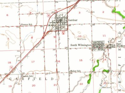
Every edition of the U.S. Geological Survey’s map of South Wilmington. Tap a year, or press play to watch the town change.
1948Dwight sheet · 1:62,500
U.S. Geological Survey historical topographic maps (public domain), via Esri’s collection of the scans. The red ring marks the center of South Wilmington.
Every building
South Wilmington, building by building, 1904–1910
Fire insurance maps drew every building, what it was made of and what it was used for, so insurers could price the risk of fire. Pick a year, then a sheet.
Founding dates: Wikidata, Wikipedia, the U.S. post office records of Blevins & Helbock (CC0) and the Census. Homes by year built: Census ACS 2020–24. National Register of Historic Places: National Park Service (list of May 22, 2026). Old photos, postcards and papers: Wikimedia Commons, the Library of Congress and other public archives, credited on each item’s page. Maps: U.S. Geological Survey historical topographic maps (via Esri) and Sanborn fire-insurance maps (Library of Congress). History text and census tables: Wikipedia (CC BY-SA 4.0). Places that used to be: USGS Geographic Names Information System (2021). How TownRatings grades history →
From Wikipedia, U.S. Geological Survey historical maps, U.S. Census counts (via Wikipedia), the US Post Offices dataset (Blevins & Helbock), the USGS Geographic Names Information System, Sanborn fire insurance maps (Library of Congress) and old county and town histories (Internet Archive). Archive images are copied here with their credits and licenses, shown on each photo’s page. Refreshed monthly.