Peaked at 1,078 in 1870; 407 people lived here in 2020.
17 censuses, 1860–2020.
U.S. Census Bureau decennial counts, from the census table on Prairie City’s Wikipedia page.
Every building
Prairie City, building by building, 1893–1912
Fire insurance maps drew every building, what it was made of and what it was used for, so insurers could price the risk of fire. Pick a year, then a sheet.
Sanborn Map Company, via the Library of Congress. Editions published in 1930 or earlier, which are in the public domain.
The story so far
Prairie City, in brief
Wikipedia doesn’t have a history of Prairie City yet. The photos, dates and memories neighbors add here are how it gets written.
Prairie City is a village in McDonough County, Illinois, United States. The population was 407 at the 2020 census.
Its first post office opened in 1855. Between the 2010 and 2020 censuses its population grew from 379 to 407 (+7%).
Intro from Wikipedia. Population: U.S. Census Bureau.
From the old history books
What they wrote about Prairie City, 1878–1885
Passages that mention Prairie City, cut from the printed page as they were published.
History of McDonough County, Illinois, together with sketches of the towns, villages and townships, educational, civil, military and political history1885 · page 757Read the page →
Read the text
As the history of this township is, to a great extent, identical with that of the town of Prairie City, all necessary details will be found in connection with the record of that place, in this chapter, or in the following sketches of PROMINENT CITIZENS.
Text read by machine from the scan; it may contain errors.
History of McDonough County, Illinois1878 · page 262Read the page →
Read the text
Prairie City Chronicle. — This was the name of the first paper published in the town of Prairie City, the first number of which bears date April 23, 1857. It was edited and published by R. W.
Text read by machine from the scan; it may contain errors.
History of McDonough county, Illinois1878 · page 262Read the page →
Read the text
Prairie City Chronicle. — This was the name of the lirst paper published in the town of Prairie City, the lirst number of which bears date April 23, 1857. It was edited and published by R. "W.
Text read by machine from the scan; it may contain errors.
History of McDonough County, Illinois1878 · page 414Read the page →
Read the text
Prairie City Academy. — This institution was organized by special charter in the year 1859, in the village of Prairie City, with Prof. Daniel Branch as Principal, and Mrs. S. F. W. Branch, Assistant.
Text read by machine from the scan; it may contain errors.
Scans and text from the Internet Archive. Books published in 1930 or earlier, which are in the public domain.
Timeline
Prairie City, 1855 to 1915
Woven from the archive, old maps, post office records, the National Register and the people born here.
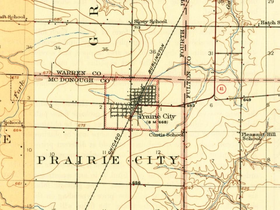
Every edition of the U.S. Geological Survey’s map of Prairie City. Tap a year, or press play to watch the town change.
1915Avon sheet · 1:62,500
U.S. Geological Survey historical topographic maps (public domain), via Esri’s collection of the scans. The red ring marks the center of Prairie City.
Places that used to be
Places now gone and burying grounds
Prairie City’s post office has been open since 1855.
Gone or out of use
Prairie City AirportairportPrairie City Community ChurchchurchPrairie City High SchoolschoolPrairie City Methodist Episcopal ChurchchurchPrairie Land Community Centerbuilding
1cemetery inside Prairie City
Prairie City
US Post Offices dataset (Blevins & Helbock, CC0). Places and cemeteries from the USGS Geographic Names Information System (2021).
Questions about Prairie City’s history
What year was Prairie City founded?
The Prairie City post office opened in 1855, the earliest record of the town by name (U.S. post office records).
Founding dates: Wikidata, Wikipedia, the U.S. post office records of Blevins & Helbock (CC0) and the Census. Homes by year built: Census ACS 2020–24. National Register of Historic Places: National Park Service (list of May 22, 2026). Old photos, postcards and papers: Wikimedia Commons, the Library of Congress and other public archives, credited on each item’s page. Maps: U.S. Geological Survey historical topographic maps (via Esri) and Sanborn fire-insurance maps (Library of Congress). History text and census tables: Wikipedia (CC BY-SA 4.0). Places that used to be: USGS Geographic Names Information System (2021). How TownRatings grades history →
From Wikidata and Wikipedia for famous people, U.S. Geological Survey historical maps, U.S. Census counts (via Wikipedia), the US Post Offices dataset (Blevins & Helbock), the USGS Geographic Names Information System, Sanborn fire insurance maps (Library of Congress) and old county and town histories (Internet Archive). Archive images are copied here with their credits and licenses, shown on each photo’s page. Refreshed monthly.