Fire insurance maps drew every building, what it was made of and what it was used for, so insurers could price the risk of fire. Pick a year, then a sheet.
In 1829, present-day Chicago Road was part of the Frink and Walker stagecoach line from Galena, Illinois to Chicago, though the Potawatomi Indians were the first to use the trail. The tribe didn't turn over the area to the U.S. government until 1833. Frink and Walker also held the mail contract for the area's settlers. The route became popular and garnered a mention in the work of writer Margaret Fuller.
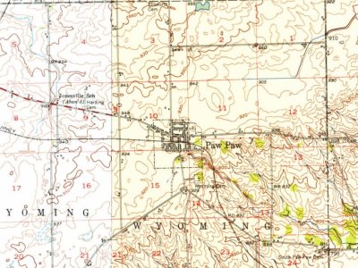
Wyoming, the southeastern township of Lee county, is the congressional T. 37 N., E. 2 E. of the 3d P.M., and is bounded north by Willow creek, on the east by Paw Paw in De Kalb county, south by Earlville in La Salle county, and west by Brookljai. In the days of precincts it formed the south third of Paw Paw precinct, and when set off and organized as a township in 1850 was named Paw Paw township, and since the beautiful grove, hereafter described, that gave this name stands almost wholly in this township, and the post-office is named Paw
Text read by machine from the scan; it may contain errors.
Over east, partly in Lee county and partly in DeKall) county, there was erected tlie village of East Paw Paw, once the most promising and prosperous place between Dixon and Chicago. In Wyoming township, the present village, west of the grove, was called Paw Paw Grove or West Paw Paw, and on Aug. 1, 1871, it was platted as Paw Paw Grove.
Text read by machine from the scan; it may contain errors.
The Joliet, Rockt'ord & JSTorthern railroad, to be built by the Chicago, Burlington & Quincy Railroad Company, is under contract and located between Paw Paw and Sheridan, intersecting the branch of the latter road at the former place, and is to be extended from Paw Paw both ways to Joliet and Rockford. Grading, just begun (October 1881) at Paw Paw, is to be rapidly completed between the present termini.
Text read by machine from the scan; it may contain errors.
History of Lee County, Illinois1914 · page 516Read the page →
Read the text
"The grim destroyer did not pause a moment to witness the devastation wrought, but hurried on across the fields; the road running south from Paw Paw was crossed just south of Frank McBride's, whose barn, east of his house, was shattered; the east and west road to South Paw Paw was crossed between Jack Reams' and the bridge over the railroad. The Reams house seems to have been on the extreme western edge of the storm's track ; an addition on the east side of the house was wrecked, and
Text read by machine from the scan; it may contain errors.
Scans and text from the Internet Archive. Books published in 1930 or earlier, which are in the public domain.
Founding dates: Wikidata, Wikipedia, the U.S. post office records of Blevins & Helbock (CC0) and the Census. Homes by year built: Census ACS 2020–24. National Register of Historic Places: National Park Service (list of May 22, 2026). Old photos, postcards and papers: Wikimedia Commons, the Library of Congress and other public archives, credited on each item’s page. Maps: U.S. Geological Survey historical topographic maps (via Esri) and Sanborn fire-insurance maps (Library of Congress). History text and census tables: Wikipedia (CC BY-SA 4.0). Places that used to be: USGS Geographic Names Information System (2021). How TownRatings grades history →
From Wikimedia Commons (7), Wikipedia, Wikidata and Wikipedia for famous people, U.S. Geological Survey historical maps, U.S. Census counts (via Wikipedia), the US Post Offices dataset (Blevins & Helbock), the USGS Geographic Names Information System, Sanborn fire insurance maps (Library of Congress) and old county and town histories (Internet Archive). Archive images are copied here with their credits and licenses, shown on each photo’s page. Refreshed monthly.




 2007
 2006
 2006
 2006
 2006
 2006
 2005

