Guest, Sign inJoin

Post to Panola Township

We’ll email a one-tap link to publish your post. No password, and nothing is public until you click it.
Already a member? Sign in
–Not graded
History · Panola Township

Panola Township’s post office opened in 1892, and 19% of its homes were built before 1940

Below: maps from 1958 on and the census since 1880.

1892first post office
0on the National Register
19%homes built before 1940
Quick answers

How Panola Township began

When was Panola Township founded?

1892

The Panola Township post office opened in 1892, the earliest record of the town by name.

First census: 127 in 18802020 census: 375134 years
Founding year: the first Panola Township post office (Blevins & Helbock, CC0).The full story ↓

What stands out about Panola Township’s past

Read from the archive, the National Register and the record. The page puts what stands out first.

★ What stands out · Help out

Start Panola Township’s collection

The first neighbors to add old photos shape how Panola Township’s history is told.

Decades since 1900 with photos
00s10s20s30s40s50s60s70s80s90s
0 of 10 decades. The empty ones are waiting for someone’s album.
People over time

Panola Township, census by census

010018801900192019401960198020002020Peak: 148

Peaked at 148 in 1900; 47 people lived here in 2020.

15 censuses, 1880–2020.

U.S. Census Bureau decennial counts, from the census table on Panola Township’s Wikipedia page.

The story

How Panola Township came to be

From Wikipedia’s history of Panola Township.

Read it all →

Some sources, including Stewart, pg. 362, as well as several Woodford County history books claim the name Panola was fabricated by J.B. Calhoun, land commissioner of the Illinois Central Railroad, by arbitrarily combining single consonants and vowels. However, the 1954 El Paso Story correctly records that while Panola was assigned by an official of the Illinois Central Railroad, it simply duplicates the name of Panola County, Mississippi as well as several municipalities in the southern U.S. named Panola. Panola is a Native American word for cotton.

Text from Wikipedia, licensed CC BY-SA 4.0.

By decade

No old photos in the archives yet

Weddings on Main Street, storms, parades, school pictures, the old store. If it’s in your family album, it belongs here.

Be the first to add onePhotograph a print flat, in daylight, no flash.
Add from your album
On the map

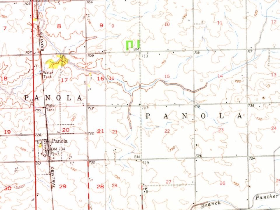
Panola Township on the map, 1958 to 1999

Every edition of the U.S. Geological Survey’s map of Panola Township. Tap a year, or press play to watch the town change.

Panola Township on the 1958 USGS mapPanola Township on the 1983 USGS mapPanola Township on the 1999 USGS map1958Flanagan sheet · 1:62,500

U.S. Geological Survey historical topographic maps (public domain), via Esri’s collection of the scans. The red ring marks the center of Panola Township.

Places that used to be

Places now gone and burying grounds

Gone or out of use
Corn Alley Airportairport
2cemeteries and burying grounds inside Panola Township
BaughmanSaint Marys

Places and cemeteries from the USGS Geographic Names Information System (2021).

Stories next door

History across the town line

Each neighbor’s History grade, on the same three inputs.

Questions about Panola Township’s history

What year was Panola Township founded?

The Panola Township post office opened in 1892, the earliest record of the town by name (U.S. post office records).

Memory lane

What the archives can’t tell you, neighbors can.

Town Square →
Start a conversation
Sources

Where this page comes from

Founding dates: Wikidata, Wikipedia, the U.S. post office records of Blevins & Helbock (CC0) and the Census. Homes by year built: Census ACS 2020–24. National Register of Historic Places: National Park Service (list of May 22, 2026). Old photos, postcards and papers: Wikimedia Commons, the Library of Congress and other public archives, credited on each item’s page. Maps: U.S. Geological Survey historical topographic maps (via Esri) and Sanborn fire-insurance maps (Library of Congress). History text and census tables: Wikipedia (CC BY-SA 4.0). Places that used to be: USGS Geographic Names Information System (2021). How TownRatings grades history →

From Wikipedia, U.S. Geological Survey historical maps, U.S. Census counts (via Wikipedia) and the USGS Geographic Names Information System. Archive images are copied here with their credits and licenses, shown on each photo’s page. Refreshed monthly.