Momence dates to 1846, and 34% of its homes were built before 1940
More historic than 96% of U.S. towns · #26 of 768 in Illinois. What drives it
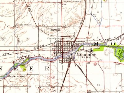
2 places in town are on the National Register, among them a historic district with 49 buildings. Below: 2 old photos and papers, maps from 1885 on, and the census since 1880.
Founding year: Wikidata; Wikipedia’s history section gives the same year. First post office: 1839.The full story ↓
History grade
What drives Momence’s History grade
On its age, its old homes and the National Register, Momence is more historic than 96% of U.S. towns, #26 of 768 in Illinois. All 3 inputs are above most U.S. towns; its National Register listings ranks highest and its age lowest.
A+
HistoryA character grade: shown, never part of Momence’s overall grade.
Few Illinois towns list much on the Register (a typical Illinois town has 0.5 per 10,000 residents, the U.S. 2.4), so Momence’s 152 sits above most of its state (95% of Illinois towns have fewer) while its 50 historic buildings outnumber those of 85% of U.S. towns.
How sure. Graded on any two of the three inputs instead, the letter would range from A to A+. The pre-1940 share is a Census survey estimate (±9.7 points). Two sources give 1846.
Founding year: Wikidata (other dates in Quick answers). Homes: Census ACS 2020–24. National Register: National Park Service, May 2026 list; each listing counted once (boundary changes and added documentation belong to their listing), and a historic district counts its contributing buildings. How TownRatings grades history →
What stands out about Momence’s past
Read from the archive, the National Register and the record. The page puts what stands out first.
Fire insurance maps drew every building, what it was made of and what it was used for, so insurers could price the risk of fire. Pick a year, then a sheet.
First known as "Lower Crossing", Momence was named after a local Potawatomi, Isadore Moness. Momence was first platted by Dr. Hiram Todd in 1846. It is located on the Kankakee River. In July, 1893, a crew paid for by an appropriation from the neighboring State of Indiana cut a shallow channel not quite a meter deep through a limestone ledge running just east of Momence, which had for millennia partially blocked and restricted the flow of the Kankakee River, making up to that point the Grand Kankakee Marsh, then the nation's largest inland wetland, possible. The increased river flow, while doing little for the citizens of Illinois, drained thousands of acres of Indiana wetlands, permitting them to be profitably farmed, while destroying most of the marsh.
Passages that mention Momence, cut from the printed page as they were published.
Tales of an old "bordertown" and along the Kankakee1925 · page 78Read the page →
Read the text
Momence took steps to incorporate as a village nearly three-quarters of a century ago. At that time the little settlement of the river had near unto two hundred souls, five or six stores and several small industries. The truth is, Momence was a smug, tight little border settlement of substance while Kankakee was still an infant in swaddling clothes,
Text read by machine from the scan; it may contain errors.
Tales of an old "bordertown" and along the Kankakee1925 · page 180Read the page →
Read the text
many other of the early settlers about Momence, spent a portion of the winter months in the timber along the Kankakee river east of Momence getting out logs, which were floated down to the saw-mill. Momence for a time, it is said, had the only saw-mill on the river between Wilmington and the Indiana state-line. It will be remembered by many
Text read by machine from the scan; it may contain errors.
Scans and text from the Internet Archive. Books published in 1930 or earlier, which are in the public domain.
Timeline
Momence, 1839 to 1922
Woven from the archive, old maps, post office records, the National Register and the people born here.
Nothing in the archives for these yearsWeddings on Main Street, storms, parades, school pictures, the old store. If it’s in your family album, it belongs here.
Momence’s post office has been open since 1849. Another post office, Lorain, opened and closed inside today’s town.
Lorain
1839–1849
Momence
1849–today
18301930today
US Post Offices dataset (Blevins & Helbock, CC0). Places and cemeteries from the USGS Geographic Names Information System (2021).
Questions about Momence’s history
What year was Momence founded?
In 1846, according to Wikidata and Wikipedia’s history of the town. Momence’s post office opened in 1839, and the census of 1880 counted 1,037 people here.
How does Momence rank for history?
Momence is more historic than 96% of U.S. towns, #26 of 768 in Illinois. The History grade combines the town’s founding era, the share of homes built before 1940 and its National Register listings. It’s a character grade, so it isn’t part of the overall grade. How it works.
What is on the National Register in Momence?
Two places: the Downtown Momence Historic District (listed 2006) and the Chipman, Edward, Public Library (2017).
How old are the homes in Momence?
34% of Momence’s homes were built before 1940 (Census estimate, ±9.7 points), against a typical 11% for an Illinois town; the median home was built in 1960.
Founding dates: Wikidata, Wikipedia, the U.S. post office records of Blevins & Helbock (CC0) and the Census. Homes by year built: Census ACS 2020–24. National Register of Historic Places: National Park Service (list of May 22, 2026). Old photos, postcards and papers: Wikimedia Commons, the Library of Congress and other public archives, credited on each item’s page. Maps: U.S. Geological Survey historical topographic maps (via Esri) and Sanborn fire-insurance maps (Library of Congress). History text and census tables: Wikipedia (CC BY-SA 4.0). Places that used to be: USGS Geographic Names Information System (2021).
From Wikimedia Commons (5), Wikidata (1), the National Register of Historic Places (2), Wikipedia, Wikidata and Wikipedia for famous people, U.S. Geological Survey historical maps, U.S. Census counts (via Wikipedia), the US Post Offices dataset (Blevins & Helbock), the USGS Geographic Names Information System, Sanborn fire insurance maps (Library of Congress) and old county and town histories (Internet Archive). Archive images are copied here with their credits and licenses, shown on each photo’s page. Refreshed monthly.


 2006
 2006
 2006


