Peaked at 1,002 in 1920; 505 people lived here in 2020.
14 censuses, 1890–2020.
U.S. Census Bureau decennial counts, from the census table on Creal Springs’ Wikipedia page.
Every building
Creal Springs, building by building, 1895–1910
Fire insurance maps drew every building, what it was made of and what it was used for, so insurers could price the risk of fire. Pick a year, then a sheet.
1895Sheet 1 of 1
Edition
Sheets
BrickWoodStone
Sanborn Map Company, via the Library of Congress. Editions published in 1930 or earlier, which are in the public domain.
In the early 19th century, Lusk's Ferry Road was an important road that connected Fort Kaskaskia with Lusk's Ferry on the Ohio River. The original survey maps of Illinois show a short segment of this road south of Creal Springs, in Johnson County. This old road most likely ran from Marion through Creal Springs before ascending to the summit of the Shawnee Hills. The modern road running toward the southeast into Creal Springs may be the old road. The road leading south out of Creal Springs toward Lake of Egypt links into the Wagon Creek Road, which leads to the segment mapped in the original survey. Modern maps also show traces of an older road that ran south out of Creal Springs along a less direct line.
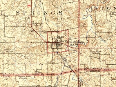
Every edition of the U.S. Geological Survey’s map of Creal Springs. Tap a year, or press play to watch the town change.
1925Marion sheet · 1:62,500
U.S. Geological Survey historical topographic maps (public domain), via Esri’s collection of the scans. The red ring marks the center of Creal Springs.
Famous people
Famous people close to Creal Springs
Nobody well known was born in Creal Springs itself, so here are the best known from just nearby.
Founding dates: Wikidata, Wikipedia, the U.S. post office records of Blevins & Helbock (CC0) and the Census. Homes by year built: Census ACS 2020–24. National Register of Historic Places: National Park Service (list of May 22, 2026). Old photos, postcards and papers: Wikimedia Commons, the Library of Congress and other public archives, credited on each item’s page. Maps: U.S. Geological Survey historical topographic maps (via Esri) and Sanborn fire-insurance maps (Library of Congress). History text and census tables: Wikipedia (CC BY-SA 4.0). Places that used to be: USGS Geographic Names Information System (2021). How TownRatings grades history →
From Wikimedia Commons (1), Wikipedia, U.S. Geological Survey historical maps, U.S. Census counts (via Wikipedia), the US Post Offices dataset (Blevins & Helbock), the USGS Geographic Names Information System and Sanborn fire insurance maps (Library of Congress). Archive images are copied here with their credits and licenses, shown on each photo’s page. Refreshed monthly.


 2016


