Bellflower was laid out on August 26, 1871, by George Nelson Black (March 15, 1833 – April 22, 1908) and his wife Louisa J. Black (December 22, 1840 – December 23, 1909). George was born in Berkshire County, Massachusetts, and had come to Springfield, Illinois, in 1850, where he became wealthy through manufacturing, mining, and railroads. Bellflower Township had subscribed $30,000 in twenty-year bonds toward the construction of what was then called the Gilman, Clinton and Springfield Railroad. A condition of the funding was that the township would have a station on the railroad. Black purchased 100 acres (0.40 km2) of land, laid 40 acres (160,000 m2) out into town lots and then transferred the title to the railroad. When the railroad became property of the Illinois Central Railroad, town lots in Bellflower were not transferred to that railroad. The name of the town came from the name of…
Passages that mention Bellflower, cut from the printed page as they were published.
History of McLean County, Illinois1924 · page 84Read the page →
Read the text
Bellflower Township. — This township was originally named Prairie when the township organization was effected in 1858. It was the only township in the county which possessed no timber. The first supervisor, Jesse Richards, chose the name of Bellflower, that being his favorite apple. It is the most southeasterly township of the county. It was first used as a cattle range by the pioneers of Cheney's Grove and other sections. The township possessed much wet land, classified by the government as swamp land, and this was donated by the county commissioners
Text read by machine from the scan; it may contain errors.
History of McLean County, Illinois1924 · page 282Read the page →
Read the text
Bellflower — John S. Harper started the Bellflower Journal, which ran until about 1904 with several changes of owners. Colfax — The weekly Press is edited by H. C. Van Alstine, who succeeded A. E. Potts, founder of the paper about 1897. Part of the edition is printed under the name of Cooksville Enterprise and filled with Cooksville news.
Text read by machine from the scan; it may contain errors.
Scans and text from the Internet Archive. Books published in 1930 or earlier, which are in the public domain.
Timeline
Bellflower, 1871 to 1952
Woven from the archive, old maps, post office records, the National Register and the people born here.
Nothing in the archives for these yearsWeddings on Main Street, storms, parades, school pictures, the old store. If it’s in your family album, it belongs here.
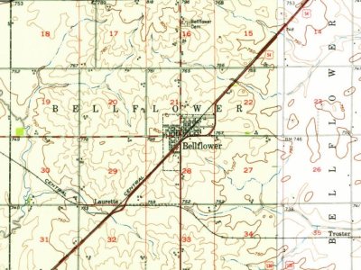
Every edition of the U.S. Geological Survey’s map of Bellflower. Tap a year, or press play to watch the town change.
1952Arrowsmith sheet · 1:62,500
U.S. Geological Survey historical topographic maps (public domain), via Esri’s collection of the scans. The red ring marks the center of Bellflower.
People over time
Bellflower, census by census
Between 346 and 442 people in every census since 1900.
13 censuses, 1900–2020.
U.S. Census Bureau decennial counts, from the census table on Bellflower’s Wikipedia page.
Questions about Bellflower’s history
What year was Bellflower founded?
In 1871, according to Wikidata and Wikipedia’s history of the town. Bellflower’s post office opened in 1872, and the census of 1900 counted 356 people here.
Founding dates: Wikidata, Wikipedia, the U.S. post office records of Blevins & Helbock (CC0) and the Census. Homes by year built: Census ACS 2020–24. National Register of Historic Places: National Park Service (list of May 22, 2026). Old photos, postcards and papers: Wikimedia Commons, the Library of Congress and other public archives, credited on each item’s page. Maps: U.S. Geological Survey historical topographic maps (via Esri) and Sanborn fire-insurance maps (Library of Congress). History text and census tables: Wikipedia (CC BY-SA 4.0). Places that used to be: USGS Geographic Names Information System (2021). How TownRatings grades history →
From Wikimedia Commons (1), Wikipedia, Wikidata and Wikipedia for famous people, U.S. Geological Survey historical maps, U.S. Census counts (via Wikipedia), the US Post Offices dataset (Blevins & Helbock), the USGS Geographic Names Information System and old county and town histories (Internet Archive). Archive images are copied here with their credits and licenses, shown on each photo’s page. Refreshed monthly.