CSO, Census 2022 · Limerick City and County Council
Median age
45.1
23% are 65+ · Co. Limerick 15%
Degree level
20%
of residents 15+ · Irish towns 36%
Walk, cycle, transit
10%
of working residents · Irish towns 23%
Is Drumcollogher a good place to live?
Homes sell for a median €206,400, about 4.5 times what a household here earns in a year. Its architectural heritage runs to 10 buildings on the national inventory. 8% of residents were born outside Ireland.
Irish towns are graded from 1,000 residents, which leaves Drumcollogher out for now.
What makes Drumcollogher stand out
The 3 things Drumcollogher does most differently from other towns.
Data highlights are ordered by what stands out in Drumcollogher.
Natural hazards
Few natural hazards in Drumcollogher: low radon, steady ground and few homes low by big water
Radon is rarely a worry in Drumcollogher: under 1% of homes are estimated above the reference level. Landslides: none of Drumcollogher lies in a high-susceptibility zone. Low ground by water holds almost none of its homes.
EPA radon map, GSI landslide susceptibility and our low-lying homes estimate from OPW LiDAR.
Climate
Summers stay cool in Drumcollogher: July afternoons reach 19.5°C, below Co. Limerick’s towns and Irish towns
January nights bottom out at 2.5°C in Drumcollogher, lower than both Co. Limerick’s towns (2.9°C) and Irish towns (2.9°C). The mean temperature over a year in the town is 10.0°C. The town gets 1,111 mm of rain a year.
19.5°CJuly afternoon high
Average afternoon highs by season · 1991–2020 averages
Drumcollogher has 92 people with a disability for every 100 its ages predict, fewer than in Co. Limerick’s towns and across Irish towns
Ages taken into account, Drumcollogher counts 96 people in poor health for every 100 predicted. 85% of the town’s residents described their health as good or very good at the census, lower than both Co. Limerick’s towns (86%) and Irish towns (88%). At the census, 2.3% of people here described their health as bad or very bad.
85%good or very good health
Per 100 expected at the town’s ages · age-standardised
Bad health96
Disability92
Co. Limerick171
Expected100
General health, self-reported
Good or very good 85%Fair 13%Bad or very bad 2%
Census 2022
Drumcollogher
Co. Limerick
Ireland
Good or very good health
85%
86%
88%
Bad or very bad health
2.3%
2.9%
2%
Unpaid carers
5.9%
5.5%
5.4%
With a disability
23%
25%
22%
96
bad health per 100 expected · Co. Limerick 171
92
disability per 100 expected · Co. Limerick 115
82.5 · 79
life expectancy, women · men, the Mid-West region, 2016
CSO, Census 2022 general health, disability and carers · CSO life expectancy by region, 2016 · HSE medical cards, 2024 · TownRatings age-standardised ratios
Housing
Social housing is more common in Drumcollogher than in Co. Limerick’s towns or across Irish towns, at 25% of households
56% of households own their home, lower than both Co. Limerick’s towns (59%) and Irish towns (61%). Renting privately is how 18% of households live.
Property Price Register · CSO residential prices by Eircode area · RTB rents · CSO, Census 2022 tenure · The price is for the postcode area P56, not the town alone: too few sales inside the town carry a full address.
Outdoors
Drumcollogher has more park space per resident than 8 in 10 Irish towns
Green space comes to 10.9 ha for every 1,000 people in Drumcollogher. This Co. Limerick town has one park, with 6 ha of green space in all. 75% of homes are within 400 m of green space, below Co. Limerick’s towns (91%) and Irish towns (92%) alike.
75%of homes near green space
Green space per 1,000 residents · per 1,000 residents
OpenStreetMap parks and paths, NPWS protected sites and the National Trails Register.
Weather
Weather in Drumcollogher: 10 degrees and light showers today
The heaviest rain of the week is due on Tuesday, around 6 mm. In November a normal day reaches 11°C and a normal night 4°C; the forecast for Drumcollogher below sets each day against them. A passing shower is possible today, but barely measurable; the breeze reaches 20 km/h, and the low is 4°C.
10°C / 4°CToday
This month and the next three, normal highs · 1991–2020 averages
Forecast: MET Norway (CC BY 4.0) · normals: Met Éireann, 1991–2020
Work & commute
Walking, cycling and public transport carry fewer commuters in Drumcollogher than in Co. Limerick’s towns or Irish towns: 9.8%
Home was the main workplace for 5.7% of workers at the census. 83% of commuters drove, above Co. Limerick’s towns (65%) and Irish towns (66%) alike. At the census, 70% of people aged 15 to 64 had a job.
CSO, Census 2022 travel to work, work and education · CSO Geographical Profiles of Income 2022 · Live Register · Census day was 3 April 2022, with working from home still common; shares are of those who travelled.
Who lives here
An older town: 23% of people in Drumcollogher are 65 or over, more than in Co. Limerick’s towns and across Irish towns
Foreign-born residents make up 7.5% of the population. The 15-to-24 age group: 10%, lower than both Co. Limerick’s towns (13%) and Irish towns (12%). Under 15: 16% of residents.
45.1median age
DrumcollogherCo. LimerickIreland
Ages · share of residents
23%
Under 1515–2425–4445–6465+
Highest education · residents 15 and older who have finished education
Primary or none18%
Lower secondary20%
Leaving Cert34%
Diploma or cert7%
Degree or higher20%
Women and men · all residents
Women make up 49.1% of Drumcollogher
WomenIrelandMen
250 women and 259 men live here; across Ireland, women are 50.6%.
CSO, Census 2022 · Co. Limerick and Ireland: the median of their towns of 2,500+
Town hall
More people in Drumcollogher vote than in Co. Limerick’s towns or Irish towns: 57% turnout at the local elections
61% voted at the general election. The voters of Limerick City and County Council also elect its mayor directly: John Moran (Independent), since 7 June 2024. There is no majority on Limerick City and County Council; Fine Gael have the most seats, 13 of 40, short of 21.
13/40seats held by Fine Gael
Seats on Limerick City and County · June 2024
Fine Gael13
Fianna Fáil10
Independent5
Sinn Féin3
Labour Party3
Independent Ireland2
Social Democrats2
Aontú1
Turnout
Drumcollogher
Co. Limerick
Ireland
Local elections, June 2024
57%
48%
46%
General election, November 2024
61%
55%
59%
6
Councillors
13/40
Fine Gael seats on Limerick City and County, the largest party
NIAH, the National Inventory of Architectural Heritage · Sites and Monuments Record · CSO, Census 2022 homes by year built
Schools
Schools around Drumcollogher have lost ground: pupils −4% since 2019, below Co. Limerick’s towns and Irish towns
DEIS, the support scheme, covers 25% of them, below Co. Limerick’s towns (46%) and Irish towns (35%) alike. Families in Drumcollogher have 4 schools within 3 km to choose from: 3 primary schools and 1 secondary school. For secondary school, the closest is Hazelwood College, 0.6 km from the town.
Department of Education school lists, 2025/26 (preliminary) · no results are published by school · Letters and results are missing here for a reason: Ireland publishes neither school by school.
Nearby attractions
National Co-op Museum and 3 more in and around Drumcollogher
Castles, abbeys, gardens, museums and days out in and near Drumcollogher. Best known first.
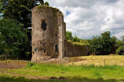
The national inventory of architectural heritage lists 10 buildings in Drumcollogher, each rated of regional importance. 3 archaeological sites are on the record here.
Pat O'Callaghan: Unknown author Unknown author, Public domain · Hanna Sheehy-Skeffington: Underwood & Underwood, New York, Public domain · Daniel Mannix: Fairfax Corporation, Public domain
Drumcollogher’s neighbours
The nearest places of 1,000 or more. Boundaries: Tailte Éireann, CSO Urban Areas 2022 and Electoral Divisions.
People: CSO, Census 2022. Distances: centre to centre.
Questions about Drumcollogher
How do people in Drumcollogher get to work?
6% mostly work from home, and 43% of journeys take under 15 minutes.
Is Drumcollogher growing?
Drumcollogher had 509 people at the 2022 census, down from 518 in 2016: 1.7% fewer, while the median of Irish towns grew 7.6%.
Is Drumcollogher a young town or an old one?
The median age in Drumcollogher is 45.1, against 37.6 in the median of Irish towns.
About Drumcollogher
Urban area in Co. Limerick
Drumcollogher has 509 people, in the area of Limerick City and County Council. TownRatings uses the CSO’s 2022 Urban Areas as Ireland’s towns: the physical town, as people mean the word, rather than a county or a council area, so its figures cover the town itself.
Built from Tailte Éireann’s boundaries and the CSO’s Census 2022 (CC BY 4.0)
Population
509 (CSO, Census 2022)
County
Limerick
Council
Limerick City and County Council
Local electoral area
Newcastle West
Dáil constituency
Limerick County
Area
0.2 sq mi (0.4 km²)
CSO code
UA:21526
Sources: CSO, Census 2022 Small Area Population Statistics (CC BY 4.0) · Tailte Éireann, Urban Areas and Electoral Divisions 2022 (CC BY 4.0). Under Creative Commons Attribution 4.0 (CC BY 4.0).
Contains Central Statistics Office (CSO) data, Census 2022, and Tailte Éireann boundaries (CSO Urban Areas, Small Areas, local electoral areas, constituencies), under Creative Commons Attribution 4.0 (CC BY 4.0).