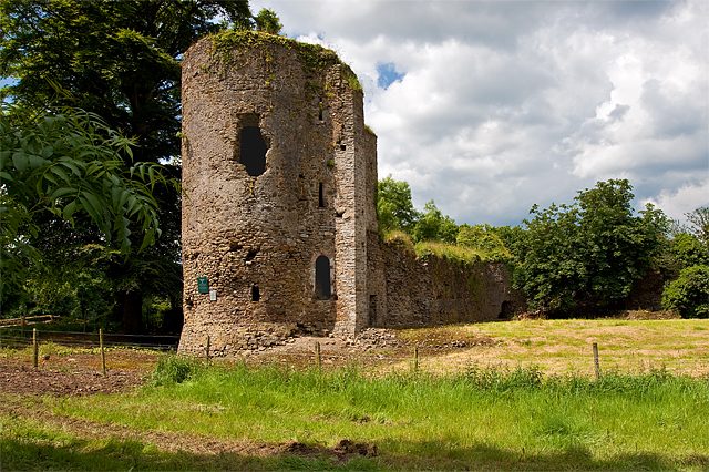
Kilbolane Castle
Kilbolane Castle is a Norman style castle. It lies 400 m southeast of Milford. Nearby, Liscarroll Castle (9.1 km) heads a list of 6 within 15 km.
Castle near Milford
Just outside Milford
Kilbolane Castle is 400 m southeast of Milford. Towns near it ↓
Written from Fáilte Ireland’s open data, OpenStreetMap, Wikidata and the CSO’s 2022 town outlines, with Met Éireann’s 1991–2020 averages.
A month-by-month guide
For warmth, aim for June to September (17–19°C highs in Milford).
Kilbolane Castle
Wikipedia covers it in 5 languages. You will find it in County Cork.
- Type
- Castle
- Wikipedias
- Covered in 5 languages
- Town
- 400 m southeast of Milford
- Official site
- visitballyhoura.com/explore/kilbolane-castle
How to visit
The area around Kilbolane Castle
Orange marks Kilbolane Castle, and the numbered points match the list of places below.
© OpenStreetMap contributors · CSO 2022 outline
Towns near Kilbolane Castle
The biggest base of the 8 is Drumcollogher (509 people). Every town below has its own grades, prices and places to visit.
Milford
Drumcollogher
Dromina
Newtown
Compare the 8 towns
| Town | Where Kilbolane Castle is | People | Places to visit |
|---|---|---|---|
| Milford | 400 m northwest of it | 264 | 2 |
| Drumcollogher | 3 km west of it | 509 | 4 |
| Dromina | 3.9 km southeast of it | 312 | 2 |
| Newtown | 4.7 km east of it | 433 | 1 |
| Freemount | 7.5 km south of it | 257 | 0 |
| Ballyagran | 8.5 km northeast of it | 166 | 0 |
| Broadford | 8.8 km west of it | 231 | 3 |
| Liscarroll | 9.2 km south of it | 245 | 2 |
Also near Kilbolane Castle
Also close at hand are 2 churches, a castle and a visitor farm, among 6 within 15 km.
 CastleLiscarroll Castle9.1 km away2ChurchChurchTullylease Church And Cross Slabs6.8 km away3Visitor farmVisitor farmThe Donkey Sanctuary8.9 km away4ChurchChurchKillagholehane Cemetery and Church9 km away5ZooZooWild Encounters Mini Zoo12 km away6MuseumMuseumNational Co-op Museum4.1 km away
Within 15 km, close and well known first. Numbers match the map.
Questions people have about Kilbolane Castle
Where is Kilbolane Castle?
Kilbolane Castle is 400 m southeast of Milford, Cork.
What is Kilbolane Castle?
Norman style castle in Cork, Ireland.
How well known is Kilbolane Castle?
Kilbolane Castle has 5 Wikipedia and sister-site articles in different languages: #185 of the 1,783 Irish places we list.
When is the best time to visit Kilbolane Castle?
June to September are the warmest months in Milford, with afternoon highs of 17–19°C (Met Éireann 1991–2020 averages).
What else is there to see near Kilbolane Castle?
Within 15 km: Liscarroll Castle (9.1 km), Tullylease Church And Cross Slabs (6.8 km), The Donkey Sanctuary (8.9 km) and Killagholehane Cemetery and Church (9 km).
Sources: Fáilte Ireland open data (CC BY 4.0), © OpenStreetMap contributors (ODbL), Wikidata (CC0), CSO 2022 town outlines (CC BY 4.0), Met Éireann 1991–2020 averages (CC BY 4.0).
Photos: each place’s Wikidata image, from Wikimedia Commons under the licence below (our copy, resized).
Photo credits (2)
- Kilbolane Castle: Mike Searle, CC BY-SA 2.0, Wikimedia Commons
- Liscarroll Castle: Mike Searle, CC BY-SA 2.0, Wikimedia Commons
Contains Central Statistics Office (CSO) data, Census 2022, and Tailte Éireann boundaries (CSO Urban Areas, Small Areas, local electoral areas, constituencies), under Creative Commons Attribution 4.0 (CC BY 4.0).