Ballingarry’s story
Ballingarry: 16% of homes built before 1919
The register holds 11 buildings on the National Inventory in Ballingarry.
6 archaeological sites are on the record here too.
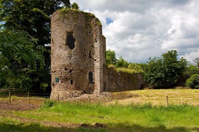
- 1680The Turret
- 1790Sheehy
- 1810Ballingarry Church
Each edition grades its towns against each other only.

A town of 570 in Co. Limerick.
At a median €311,900, a home costs 5.3 times the town’s median household income. Walking, cycling and public transport carry 9% of commuters. 11 of its buildings are on the National Inventory of Architectural Heritage. The 2022 census put unemployment at 5%.
Ballingarry is too small to grade: Irish towns get subject grades from 1,000 residents.
The 3 things Ballingarry does most differently from other towns.
The register holds 11 buildings on the National Inventory in Ballingarry.
6 archaeological sites are on the record here too.
Data highlights are ordered by what stands out in Ballingarry.
2.8% of homes stand on ground with high landslide susceptibility, above both Co. Limerick’s towns (0%) and Irish towns (0%). Its homes mostly stand clear of low ground by water.
| Share of homes | Ballingarry | Co. Limerick | Ireland |
|---|---|---|---|
| On high landslide susceptibility | 2.8% | 0% | 0% |
| In high-radon areas | 0% | 0% | 0% |
EPA radon map, GSI landslide susceptibility and our low-lying homes estimate from OPW LiDAR.
Ballingarry gets 1,038 mm of rain a year. The year’s mean temperature is 10.2°C, lower than Co. Limerick’s towns (10.5°C) and near Irish towns (10.3°C). Winter lows in Ballingarry average 2.7°C in January.
| Climate, 1991–2020 | Ballingarry | Co. Limerick | Ireland |
|---|---|---|---|
| July high | 19.5°C | 19.9°C | 19.9°C |
| Average temperature over the year | 10.2°C | 10.5°C | 10.3°C |
| January low | 2.7°C | 2.9°C | 2.9°C |
| Rain a year | 1,038 mm | 1,034 mm | 937 mm |
Met Éireann, 1991–2020 averages.
2% of residents described their health as bad or very bad, lower than Co. Limerick’s towns (2.9%) and near Irish towns (2%). Asked at the census, 89% of residents of Ballingarry said they were in good or very good health. A disability affects nearly a quarter of people locally.
| Census 2022 | Ballingarry | Co. Limerick | Ireland |
|---|---|---|---|
| Unpaid carers | 6.1% | 5.5% | 5.4% |
| Good or very good health | 89% | 86% | 88% |
| Bad or very bad health | 2% | 2.9% | 2% |
| With a disability | 23% | 25% | 22% |
CSO, Census 2022 general health, disability and carers · CSO life expectancy by region, 2016 · HSE medical cards, 2024 · TownRatings age-standardised ratios
Nearly two thirds of households own their home, above Co. Limerick’s towns (59%) and Irish towns (61%) alike. Social renters account for 18% of households.
| Housing | Ballingarry | Co. Limerick | Ireland |
|---|---|---|---|
| Households renting privately | 14% | 27% | 22% |
| Households in social housing | 18% | 13% | 13% |
| Households owning their home | 66% | 59% | 61% |
Property Price Register · CSO residential prices by Eircode area · RTB rents · CSO, Census 2022 tenure · The price is for the postcode area V94, not the town alone: too few sales inside the town carry a full address.
Ballingarry has one park, with 4 ha of green space in all. Walkers have 0.3 km per km² of paths and tracks, lower than both Co. Limerick’s towns (2.5 km per km²) and Irish towns (2.1 km per km²). Every 1,000 residents of Ballingarry share 6.2 ha of green space.
| Outdoors | Ballingarry | Co. Limerick | Ireland |
|---|---|---|---|
| Protected nature within 5 km | 0% | 9.6% | 1.8% |
| Paths per km² of town | 0.3 km per km² | 2.5 km per km² | 2.1 km per km² |
| Near a park | 100% | 91% | 92% |
| Woodland within 1 km | 0.8% | 1.5% | 2.7% |
OpenStreetMap parks and paths, NPWS protected sites and the National Trails Register.
Ballingarry’s November average makes a useful yardstick: afternoons reach 11°C, nights fall to 5°C. Expect little more than a sprinkle today, wind picking up to 21 km/h, and a low of 4°C. In December, the normal shifts to highs of 9°C and lows of 3°C.
| Season | High | Low | Rain |
|---|---|---|---|
| Winter | 9°C | 3°C | 312 mm |
| Spring | 13°C | 5°C | 206 mm |
| Summer | 19°C | 11°C | 230 mm |
| Autumn | 14°C | 7°C | 290 mm |
Forecast: MET Norway (CC BY 4.0) · normals: Met Éireann, 1991–2020
At the census, just over four in five commuters went by car. 73% of 15 to 64s were in work, above Co. Limerick’s towns (61%) and Irish towns (68%) alike. Workers spend 28 min getting to work, on average.
| Census 2022 | Ballingarry | Co. Limerick | Ireland |
|---|---|---|---|
| Unemployment rate | 4.7% | 11% | 9.2% |
| In work, 15 to 64 | 73% | 61% | 68% |
| Average trip | 28 min | 23 min | 27.6 min |
| Median household income | €58,640 | €50,710 | €57,760 |
CSO, Census 2022 travel to work, work and education · CSO Geographical Profiles of Income 2022 · Live Register · Census day was 3 April 2022, with working from home still common; shares are of those who travelled.
People aged 15 to 24 make up 10% of the town, lower than both Co. Limerick’s towns (13%) and Irish towns (12%). 13% of residents were born outside the country. Over-65s are 13% of the population.
51.8% of Ballingarry’s residents are women
295 women and 275 men live here; across Ireland, women are 50.6%.
| Ballingarry | Co. Limerick | Ireland | |
|---|---|---|---|
| Under 15 | 24% | 17% | 20% |
| 15–24 | 10% | 13% | 12% |
| 25–44 | 26% | 31% | 29% |
| 45–64 | 27% | 23% | 24% |
| 65+ | 13% | 15% | 14% |
| Primary or none | 11% | 11% | 9.7% |
| Lower secondary | 19% | 16% | 14% |
| Leaving Cert | 36% | 35% | 35% |
| Diploma or cert | 4.3% | 5.6% | 5.8% |
| Degree or higher | 30% | 31% | 36% |
CSO, Census 2022 · Co. Limerick and Ireland: the median of their towns of 2,500+
Turnout at the last local elections was 52%, above Co. Limerick’s towns (48%) and Irish towns (46%) alike. Limerick City and County Council has no ruling majority: Fine Gael hold 13 of its 40 seats, short of the 21 needed. Ballingarry sits in the Adare-Rathkeale local electoral area, which elects 6 councillors.
| Turnout | Ballingarry | Co. Limerick | Ireland |
|---|---|---|---|
| General election, November 2024 | 61% | 55% | 59% |
| Local elections, June 2024 | 52% | 48% | 46% |
Department of Housing count sheets, 2024
Homes built before 1919 account for 16.3% of the housing. The Sites and Monuments Record lists 6 sites here, below both Co. Limerick’s towns (10) and Irish towns (11).
| Heritage | Ballingarry | Co. Limerick | Ireland |
|---|---|---|---|
| Inventory buildings per 10,000 residents | 193 | 15 | 48 |
| Homes built before 1919 | 16.3% | 3.8% | 3.4% |
NIAH, the National Inventory of Architectural Heritage · Sites and Monuments Record · CSO, Census 2022 homes by year built
Within 3 km of Ballingarry there is one school. 204 pupils attend the one school within 3 km of the town.
| School | Level | Pupils | Ethos |
|---|---|---|---|
| Scoil Chriost an SlanaitheoirLargest primary schoolPrimary | Primary | 204 | Catholic |
| Schools within 3 km | Ballingarry | Co. Limerick | Ireland |
|---|---|---|---|
| In the DEIS scheme | 0% | 46% | 35% |
| Teach through Irish | 0% | 12% | 8% |
| Pupils since 2019/20 | +6% | +3% | +4% |
Department of Education school lists, 2025/26 (preliminary) · no results are published by school · No letters, no results: Irish schools aren’t ranked one by one.
Nothing to visit is mapped within 5 km of Ballingarry; these are the best known within 40 km.
 CastleBunratty Castle25 km north
 CathedralSt John's Cathedral27 km northeast
 CathedralSaint Mary's Cathedral27 km northeast
 CastleKilbolane Castle15 km south
 MuseumThe Hunt Museum27 km northeast
 Castle · Office of Public WorksDesmond Castle Adare12 km northeast
Photos: each place’s Wikidata image, from Wikimedia Commons under the licence below (our copy, resized).
11 of Ballingarry’s buildings made the national inventory of architectural heritage, all at regional importance. The national record lists 6 archaeological sites in and around the town.
5 notable people were born in Ballingarry.
The nearest places of 1,000 or more. Boundaries: Tailte Éireann, CSO Urban Areas 2022 and Electoral Divisions.
| Town | People | km | Overall | Cost | Safety | Health |
|---|---|---|---|---|---|---|
| Ballingarry | 570 | — | — | — | — | — |
| Rathkeale | 1,231 | 7.3 | — | B− | B− | D− |
| Adare | 1,224 | 11 | — | D | A | A |
| Croom | 1,240 | 11 | — | C− | A | B− |
| Newcastle West | 7,209 | 13 | A− | A | B+ | C |
| Askeaton | 1,236 | 16 | — | B | B− | D |
| Charleville Cork | 3,970 | 18 | B− | A+ | C− | C− |
People: CSO, Census 2022. Distances: centre to centre.
Ballingarry had 570 people at the 2022 census, up from 550 in 2016: 3.6% more, against 7.6% in the median of Irish towns.
The median age in Ballingarry is 39.1, against 37.6 in the median of Irish towns.
Urban area in Co. Limerick
570 people live in Ballingarry, in the area of Limerick City and County Council. TownRatings uses the CSO’s 2022 Urban Areas as Ireland’s towns: the physical town, as people mean the word, rather than a county or a council area, so its figures cover the town itself.
Built from Tailte Éireann’s boundaries and the CSO’s Census 2022 (CC BY 4.0)
Sources: CSO, Census 2022 Small Area Population Statistics (CC BY 4.0) · Tailte Éireann, Urban Areas and Electoral Divisions 2022 (CC BY 4.0). Under Creative Commons Attribution 4.0 (CC BY 4.0).
Contains Central Statistics Office (CSO) data, Census 2022, and Tailte Éireann boundaries (CSO Urban Areas, Small Areas, local electoral areas, constituencies), under Creative Commons Attribution 4.0 (CC BY 4.0).