The story
Read it all →How Whittemore came to be
From Wikipedia’s history of Whittemore.
Whittemore was platted in 1878 in anticipation of the railroad being built through the neighborhood.
Text from Wikipedia, licensed CC BY-SA 4.0.
Each edition grades its towns against each other only.
Below: maps from 1915 on and the census since 1880.
The Whittemore post office opened in 1878, the earliest record of the town by name.
Read from the archive, the National Register and the record. The page puts what stands out first.
The first neighbors to add old photos shape how Whittemore’s history is told.
Peaked at 741 in 1960; 497 people lived here in 2020.
15 censuses, 1880–2020.
U.S. Census Bureau decennial counts, from the census table on Whittemore’s Wikipedia page.
From Wikipedia’s history of Whittemore.
Whittemore was platted in 1878 in anticipation of the railroad being built through the neighborhood.
Text from Wikipedia, licensed CC BY-SA 4.0.
Passages that mention Whittemore, cut from the printed page as they were published.

The Incorporated town of Whittemore dates back of December 12, 1891, when the measure was decided at the election, which had thirty-nine ballots cast at the polls. The territory then taken into the incorporation was about the same as now comprised in the independent district, and was so large that trouble insued when the farmers were obliged to submit to the town ordinances. After a lapse of some seven years the incorporation was reduced to its present size and the town farmers were made happy.
Text read by machine from the scan; it may contain errors.
formerly belonged to Algona township, and did until the supervisors carved it out to create Lotts Creek. When the board set it off in January, 1873, it extended one mile and a half farther south than it does now, and it included the village of Whittemore. The organization election was held at the Sod Town schoolhouse February 3, 1873, when the following officers were elected: H. L. Goodrich, clerk ; A. A. Brunson, justice; Peter J. Walker and S. L. Scott, trustees; and Joe DeGraw, constable. The township remained that size until the board in April, 1885, cut off the south mile and a half and gave it to the township of Whittemore
Text read by machine from the scan; it may contain errors.Scans and text from the Internet Archive. Books published in 1930 or earlier, which are in the public domain.
Woven from the archive, old maps, post office records, the National Register and the people born here.
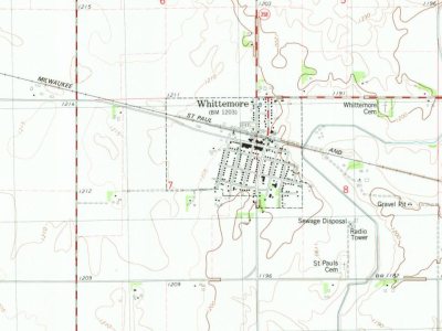 On the mapFirst mapped by the U.S. Geological Survey
The U.S. Geological Survey’s map of Whittemore.
 1980Whittermore sheet · 1:24,000
U.S. Geological Survey historical topographic maps (public domain), via Esri’s collection of the scans. The red ring marks the center of Whittemore.
Fire insurance maps drew every building, what it was made of and what it was used for, so insurers could price the risk of fire. Pick a sheet.
 1915Sheet 1 of 1
Sanborn Map Company, via the Library of Congress. Editions published in 1930 or earlier, which are in the public domain.
The Whittemore post office opened in 1878, the earliest record of the town by name (U.S. post office records).
What the archives can’t tell you, neighbors can.
Founding dates: Wikidata, Wikipedia, the U.S. post office records of Blevins & Helbock (CC0) and the Census. Homes by year built: Census ACS 2020–24. National Register of Historic Places: National Park Service (list of May 22, 2026). Old photos, postcards and papers: Wikimedia Commons, the Library of Congress and other public archives, credited on each item’s page. Maps: U.S. Geological Survey historical topographic maps (via Esri) and Sanborn fire-insurance maps (Library of Congress). History text and census tables: Wikipedia (CC BY-SA 4.0). Places that used to be: USGS Geographic Names Information System (2021). How TownRatings grades history →
From Wikimedia Commons (1), Wikipedia, U.S. Geological Survey historical maps, U.S. Census counts (via Wikipedia), the US Post Offices dataset (Blevins & Helbock), the USGS Geographic Names Information System, Sanborn fire insurance maps (Library of Congress) and old county and town histories (Internet Archive). Archive images are copied here with their credits and licenses, shown on each photo’s page. Refreshed monthly.
 2004