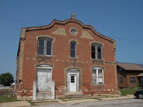
Wheatland’s post office opened in 1858, and 53% of its homes were built before 1940
Its Register listings are the City Hotel and the Henry and Elizabeth Guenther House. Below: 1 old photo or paper, maps from 1892 on, and the census since 1870.
Wheatland was platted in 1858 under the leadership of John Bennett. The town was named for President James Buchanan's estate Wheatland in Lancaster, Pennsylvania. The entire township (Spring Rock) had a white population of only 101 in 1850, but that number rose to 756 in 1860. A significant body of early settlers all came from the village of Wunderthausen in central Germany. The Germans founded the first church in town in 1857 with a Presbyterian affiliation. This relationship was dissolved in 1861 with the incorporation of St. Paul's German Reformed Church (now St. Paul's United Church of Christ). The First Presbyterian Church was organized in 1858, though no longer functions. Wheatland was legally incorporated on July 13, 1869.
“the new village in 1858 and engaged in the grain business. He previously resided on a farm just south of Wheatland. | Jesse Stine hung out his shingle as attorney at law in 1862. The first lot sold in Wheatland was purchased by him. This was on
Text read by machine from the scan; it may contain errors.
Much. of the land is now being broken by the plow and will One of the oldest manufactories in Wheatland is the Wheatland Brick and Tile Works. This brick yard was established in 1858 or '59 by John Smith who did his work by hand. The plant
Text read by machine from the scan; it may contain errors.
Wolfe's history of Clinton County, Iowa1911 · page 330Read the page →
Read the text
Wheatland is situated in Spi'ing Ri)ck tnwnship, on the Chicago & Northwestern railroad, and on the southeast ijuarter of section 9 and the northwest quarter of section 10, township 81, range i. In the early fifties, "Chubb," Erastus and William Holmes came to this part of the county and entered large tracts of land, including that upon which Wheatland stands today. It is said that a small cabin was erected near where later years stood the Peter Smith farm house. John L. Bennett, the real founder of this town, was born in 1803 in Delaware county, New York, and in 1855 he purchased the Holmes
Text read by machine from the scan; it may contain errors.
The history of Clinton County, Iowa, containing a history of the county, its cities, towns &c., biographical sketches of citizens1879 · page 577Read the page →
Read the text
Martin L. Rogers first commenced trade at Wheatland in a shanty, where he sold clothing and groceries to the hands engaged in the construction of the railroad, and was the pioneer merchant. The station was first called Yankee Run, but the name of the town was afrerward adopted. The first dry goods store was opened by William Hicks, in 1858. A post office was established, and M. L. Rogers appointed Postmaster in 1858, and continued as such until 1861. His successors have been : S. H. Rogers, 1861-70 ; John Walraven, 1870-71 ;^ W. H. Bayliss, 1871-75 ; Charles G. Rogers, 1875-79 ; John Wal-
Text read by machine from the scan; it may contain errors.
Scans and text from the Internet Archive. Books published in 1930 or earlier, which are in the public domain.
Timeline
Wheatland, 1858 to 1917
Woven from the archive, old maps, post office records, the National Register and the people born here.
Nothing in the archives for these yearsWeddings on Main Street, storms, parades, school pictures, the old store. If it’s in your family album, it belongs here.
Founding dates: Wikidata, Wikipedia, the U.S. post office records of Blevins & Helbock (CC0) and the Census. Homes by year built: Census ACS 2020–24. National Register of Historic Places: National Park Service (list of May 22, 2026). Old photos, postcards and papers: Wikimedia Commons, the Library of Congress and other public archives, credited on each item’s page. Maps: U.S. Geological Survey historical topographic maps (via Esri) and Sanborn fire-insurance maps (Library of Congress). History text and census tables: Wikipedia (CC BY-SA 4.0). Places that used to be: USGS Geographic Names Information System (2021). How TownRatings grades history →
From Wikimedia Commons (6), the National Register of Historic Places (2), Wikipedia, U.S. Geological Survey historical maps, U.S. Census counts (via Wikipedia), the US Post Offices dataset (Blevins & Helbock), the USGS Geographic Names Information System and old county and town histories (Internet Archive). Archive images are copied here with their credits and licenses, shown on each photo’s page. Refreshed monthly.


 2009
 2009
 2009
 2009
 2004