How What Cheer began, and where its name came from
When was What Cheer founded?
1865
What Cheer dates its founding to 1865 (Wikidata). The census first counted it in 1880.
First census: 719 in 18802020 census: 607161 years
How did What Cheer get its name?
What Cheer was founded in 1865 as Petersburg, named after Peter Britton, its founder.
More on the name
This name was rejected by the Post Office, forcing a change of name. Joseph Andrews, a major and veteran of the American Civil War, suggested the name "What Cheer," and the town was officially renamed on December 1, 1879.
Robert Forsyth, born in Kilmarnock, Scotland, came to America in 1857, and made his way to Rock Island, Illinois, where he arrived penniless. He worked for most of a decade as a coal miner before coming to Petersburg, the future What Cheer. In the 1870s, he began buying coal lands around town, mostly on credit. When the railroad came to town, he leased his land to the coal companies and bought into a local drug store, eventually operating stores in What Cheer, Mystic and Jerome, Iowa. Other Scots from the Kilmarnock region (Ayrshire) also settled in the area. Robert Orr came in 1875 after working in the coal mines of Colchester, Illinois. His son Alexander went on a successful career as a mine owner in Mystic.
Peaked at 3,246 in 1890; 607 people lived here in 2020.
15 censuses, 1880–2020.
U.S. Census Bureau decennial counts, from the census table on What Cheer’s Wikipedia page.
From the old history books
What they wrote about What Cheer, 1880–1903
Passages that mention What Cheer, cut from the printed page as they were published.
The history of Keokuk County, Iowa, containing a history of the county, its cities, towns, &c., a biographical directory of its citizens, war record of its volunteers in the late rebellion, history of the Northwest, history of Iowa, map of Keokuk County .1880 · page 587Read the page →
Read the text
jtrade, and for many years has enjoyed postal privileges. Although this township compares very favorably with others in fertility of soil and other natural resources, it is chiefly noted for the coal interests. The centre of the iBoal fields is the town of What Cheer, known as Petersburg until recently, when the name was changed by authority of court. It is sitiiated on section 10, and was laid out in October, 1865.
Text read by machine from the scan; it may contain errors.
A genealogical and biographical history of Keokuk County, Iowa ..1903 · page 340Read the page →
Read the text
What Cheer is the somewhat odd name of a pretty little town situated in Keokuk county, Iowa. It is on the branch of the Burlington, Cedar Rapids & Xorthern Railroad, twenty miles northeast of Oskaloosa, and is the center of an important mining industry, which adds considerable to the business prosperity of the town and surrounding country. Though not a place of great size What Cheer will compare
Text read by machine from the scan; it may contain errors.
The history of Keokuk County, Iowa, containing a history of the county, its cities, towns, &c., a biographical directory of its citizens, war record of its volunteers in the late rebellion, history of the Northwest, history of Iowa, map of Keokuk County .1880 · page 588Read the page →
Read the text
its fullest capacity. The vein is six feet thick, and lies about seventy-five feet beneath the snrface. The principal part of the coal mined in this county has been taken from the mines in the vicinity of What Cheer, and, although the mines have been situated at a distance of seven miles from the nearest railroad station, there were about 20,000 tons mined in the past year. When there is direct railroa-l communication with the mines, this will prove to be one of the most important mining regions in the State.
Text read by machine from the scan; it may contain errors.
A genealogical and biographical history of Keokuk County, Iowa ..1903 · page 334Read the page →
Read the text
business on his own account at Mapleton. continuing there until his removal to Keokuk county. Iowa, in 1879, at the solicitation of the Puriington, Cedar Rapids & Northern Railroad Company. Locating at What Cheer he opened a mine called Shaft A, and later became general manager of all the principal mines of the place, operating them until the supply of coal was exhausted, which took about nine years. In the meantime Mr. Gillfoy had been appointed general agent tor the lot association, which owned a large part of the present site of
Text read by machine from the scan; it may contain errors.
Scans and text from the Internet Archive. Books published in 1930 or earlier, which are in the public domain.
Timeline
What Cheer, 1865 to 1965
Woven from the archive, old maps, post office records, the National Register and the people born here.
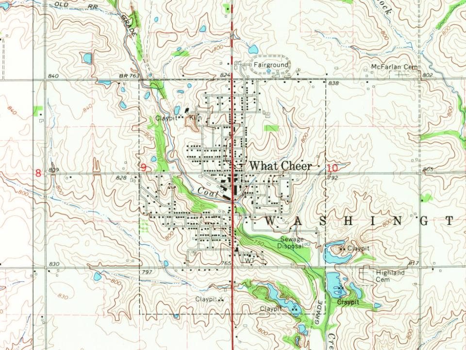
Every edition of the U.S. Geological Survey’s map of What Cheer. Tap a year, or press play to watch the town change.
1965What Cheer sheet · 1:24,000
U.S. Geological Survey historical topographic maps (public domain), via Esri’s collection of the scans. The red ring marks the center of What Cheer.
Every building
What Cheer, building by building, 1886–1916
Fire insurance maps drew every building, what it was made of and what it was used for, so insurers could price the risk of fire. Pick a year, then a sheet.
Founding dates: Wikidata, Wikipedia, the U.S. post office records of Blevins & Helbock (CC0) and the Census. Homes by year built: Census ACS 2020–24. National Register of Historic Places: National Park Service (list of May 22, 2026). Old photos, postcards and papers: Wikimedia Commons, the Library of Congress and other public archives, credited on each item’s page. Maps: U.S. Geological Survey historical topographic maps (via Esri) and Sanborn fire-insurance maps (Library of Congress). History text and census tables: Wikipedia (CC BY-SA 4.0). Places that used to be: USGS Geographic Names Information System (2021). How TownRatings grades history →
From Wikimedia Commons (4), Wikidata (1), the National Register of Historic Places (1), Wikipedia, Wikidata and Wikipedia for famous people, U.S. Geological Survey historical maps, U.S. Census counts (via Wikipedia), the US Post Offices dataset (Blevins & Helbock), the USGS Geographic Names Information System, Sanborn fire insurance maps (Library of Congress) and old county and town histories (Internet Archive). Archive images are copied here with their credits and licenses, shown on each photo’s page. Refreshed monthly.


 2016
 2016
 2016
 2004