The story
Read it all →How Oxford came to be
From Wikipedia’s history of Oxford.
Oxford was platted in 1868. It is named from Oxford Township, which takes its name from Oxford, New York.
Text from Wikipedia, licensed CC BY-SA 4.0.
Each edition grades its towns against each other only.
1 place in town is on the National Register, among them a historic district with 16 buildings. Below: 1 old photo or paper, maps from 1891 on, and the census since 1880.
The Oxford post office opened in 1855, the earliest record of the town by name. Another post office, Nemora (1865), opened inside today’s city and later closed.
Read from the archive, the National Register and the record. The page puts what stands out first.
The first neighbors to add old photos shape how Oxford’s history is told.
From Wikipedia’s history of Oxford.
Oxford was platted in 1868. It is named from Oxford Township, which takes its name from Oxford, New York.
Text from Wikipedia, licensed CC BY-SA 4.0.
Passages that mention Oxford, cut from the printed page as they were published.

Before the town of Oxford was laid out, there were a few shanties erected about the tank, and occupied by the section men, and the old Catholic Church was built a year or two before that event, which occurred in 1868, the original site being upon the southwest quarter of section 21, being sixty-nine miles from Davenport, 252 from Chicago, and 105 from Des Moines, by railroad. Oxford post-office was then kept by Mr.
Text read by machine from the scan; it may contain errors.
In 1872, Wilson and Estabrook began to deal in coal, which began at that time to be used, and has now nearly superseded wood as an article of fuel in the town of Oxford. A list of Oxford's business houses in 1881: General stores, 5; grocery, 1; hardware 3; drugs and medicines, 2; millinery and notions, 3; jewelry and music, 1; books and stationery, 1; furniture, 1; undertakers, 2; flower and feed, 1; meat market, 1; bakery and confectionery,!; livery stables, 2; lumber yard, 1; coal yard, 1 ; brick yard, 1; barber shop, 1; picture gallery, 1; flour mill, 1; hotels, 3: news-
Text read by machine from the scan; it may contain errors.Scans and text from the Internet Archive. Books published in 1930 or earlier, which are in the public domain.
Woven from the archive, old maps, post office records, the National Register and the people born here.
 Born hereClara Stover is born here
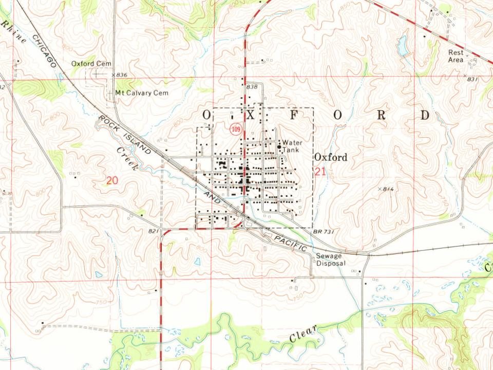
 On the mapFirst mapped by the U.S. Geological Survey
 In the archiveSheep farm and barn west of Oxford, Iowa
One decade in the archive so far: the 1980s. Scroll each row; tap a photo for its story.
Every edition of the U.S. Geological Survey’s map of Oxford. Tap a year, or press play to watch the town change.

U.S. Geological Survey historical topographic maps (public domain), via Esri’s collection of the scans. The red ring marks the center of Oxford.
No then-and-now pairs yet. Take a photo from the same spot as an old one and they appear here side by side.

Find the spot, match the angle, and add your photo. It becomes the first then-and-now pair on Oxford’s page.
Retake this view · +15The country’s official list of buildings and places worth saving.
National Park Service, National Register of Historic Places. Photos from Wikimedia Commons, credited on each place’s page.
Between 515 and 807 people in every census since 1880.
15 censuses, 1880–2020.
U.S. Census Bureau decennial counts, from the census table on Oxford’s Wikipedia page.
Writers, athletes, leaders and more, ranked by how widely they’re known.
Oxford’s post office has been open since 1855. Another post office, Nemora, opened and closed inside today’s town.
US Post Offices dataset (Blevins & Helbock, CC0). Places and cemeteries from the USGS Geographic Names Information System (2021).
The Oxford post office opened in 1855, the earliest record of the town by name (U.S. post office records).
One place: the Oxford Commercial Historic District (listed 1997).
What the archives can’t tell you, neighbors can.
Founding dates: Wikidata, Wikipedia, the U.S. post office records of Blevins & Helbock (CC0) and the Census. Homes by year built: Census ACS 2020–24. National Register of Historic Places: National Park Service (list of May 22, 2026). Old photos, postcards and papers: Wikimedia Commons, the Library of Congress and other public archives, credited on each item’s page. Maps: U.S. Geological Survey historical topographic maps (via Esri) and Sanborn fire-insurance maps (Library of Congress). History text and census tables: Wikipedia (CC BY-SA 4.0). Places that used to be: USGS Geographic Names Information System (2021). How TownRatings grades history →
From Wikimedia Commons (5), the Library of Congress (1), the National Register of Historic Places (1), Wikipedia, Wikidata and Wikipedia for famous people, U.S. Geological Survey historical maps, U.S. Census counts (via Wikipedia), the US Post Offices dataset (Blevins & Helbock), the USGS Geographic Names Information System and old county and town histories (Internet Archive). Archive images are copied here with their credits and licenses, shown on each photo’s page. Refreshed monthly.
 2009
 2009
 2009
 2009
 2004