The Okoboji post office opened in 1859, the earliest record of the town by name. Two smaller post offices, Hayward (1897) and The Inn (1910), opened inside today’s city and later closed.
2020 census: 768167 years
Founding year: the first Okoboji post office (Blevins & Helbock, CC0).
What stands out about Okoboji’s past
Read from the archive, the National Register and the record. The page puts what stands out first.
Lost post offices, old corners and places now gone
Okoboji’s post office has been open since 1859. Two other post offices opened and closed inside today’s town.
Okoboji
1859–today
Hayward
1897–1920
The Inn
1910–1940
18501940today
Hamlets and corners on the map
Village East Resort
Gone or out of use
Hayward Post Officepost officeThe Inn Post Officepost office
US Post Offices dataset (Blevins & Helbock, CC0). Places and cemeteries from the USGS Geographic Names Information System (2021).
The story so far
Okoboji, in brief
Wikipedia doesn’t have a history of Okoboji yet. The photos, dates and memories neighbors add here are how it gets written.
Okoboji is a city in Dickinson County, Iowa, United States, along the eastern shore of West Okoboji Lake in the Iowa Great Lakes region. At the time of the 2020 census, its population was 768.
Its first post office opened in 1859. Between the 2010 and 2020 censuses its population fell from 807 to 768 (-5%).
Intro from Wikipedia. Population: U.S. Census Bureau.
From the old history books
What they wrote about Okoboji, 1902–1917
Passages that mention Okoboji, cut from the printed page as they were published.
History of Emmet County and Dickinson County, Iowa1917 · page 360Read the page →
Read the text
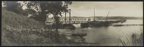
BRIDGES About the first rhention of bridges in this county was when the contractors in the swamp land deal agreed to erect the county courthouse, also three bridges — one across East Okoboji Lake east of the settlement at Spirit Lake, one across the straits between East and West Okoboji Lakes, and one across the Little Sioux River. The two bridges across the lake were finished in the year 1860, the one at Spirit Lake being three hundred feet long and the one at Okoboji two hundred and ten feet in
Text read by machine from the scan; it may contain errors.
A history of Dickinson County, Iowa, together with an account of the Spirit Lake massacre, and the Indian troubles on the northwestern frontier ..1902 · page 167Read the page →
Read the text
The impression exists in some quarters that Okoboji was a powerful Sioux chief, who formerly had his headquarters in Okoboji Grove, and that the lake was named for him. The question is often asked where Okoboji was buried, but as has been before explained, such belief is wholly unfounded.
Text read by machine from the scan; it may contain errors.
A history of Dickinson County, Iowa, together with an account of the Spirit Lake massacre, and the Indian troubles on the northwestern frontier ..1902 · page 324Read the page →
Read the text
Okoboji was one of the older townships and its first settlement noticed farther back. Indeed all of the settlements for the first ten years were confined to the three townships. Center Grove, Spirit Lake and Okoboji. The other nine were in 1868 and 1869, although the boundaries were noit established until 1872. The name Lakeville is in consequence of the many small lakes in the township togetherwith the fact that "West Okoboji forms almost the entire eastern boundary.
Text read by machine from the scan; it may contain errors.
History of Emmet County and Dickinson County, Iowa1917 · page 280Read the page →
Read the text
the county, the latter represented by the county judge, L. Congleton, to take over the swamp lands and in return erect a court-house according to the plans of the county, also three bridges, namely: one across East Okoboji Lake east of the town of Spirit Lake, one across the sti'aits between East and West Okoboji Lakes, and another across the Little Sioux River. Shortly after these arrangements were concluded Howe, Parmenter and Arthur disposed of their contract to J. S. Prescott and Henry Barkman, receiving in return several thousand acres of land.
Text read by machine from the scan; it may contain errors.
Scans and text from the Internet Archive. Books published in 1930 or earlier, which are in the public domain.
Timeline
Okoboji, 1856 to 1940
Woven from the archive, old maps, post office records, the National Register and the people born here.
Nothing in the archives for these yearsWeddings on Main Street, storms, parades, school pictures, the old store. If it’s in your family album, it belongs here.
Founding dates: Wikidata, Wikipedia, the U.S. post office records of Blevins & Helbock (CC0) and the Census. Homes by year built: Census ACS 2020–24. National Register of Historic Places: National Park Service (list of May 22, 2026). Old photos, postcards and papers: Wikimedia Commons, the Library of Congress and other public archives, credited on each item’s page. Maps: U.S. Geological Survey historical topographic maps (via Esri) and Sanborn fire-insurance maps (Library of Congress). History text and census tables: Wikipedia (CC BY-SA 4.0). Places that used to be: USGS Geographic Names Information System (2021). How TownRatings grades history →
From Wikimedia Commons (6), the National Register of Historic Places (1), the US Post Offices dataset (Blevins & Helbock), the USGS Geographic Names Information System and old county and town histories (Internet Archive). Archive images are copied here with their credits and licenses, shown on each photo’s page. Refreshed monthly.


 1908
 1908
 1908
 1908
 1908


