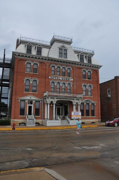
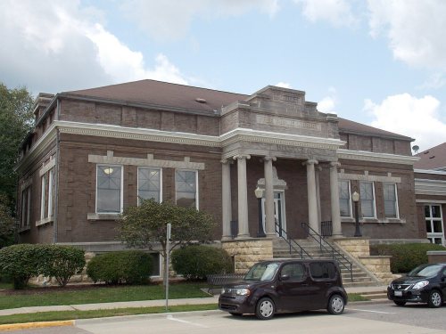
Maquoketa dates to 1838, and 25% of its homes were built before 1940
More historic than 94% of U.S. towns · #16 of 140 in Iowa. What drives it
31 places in town are on the National Register, among them three historic districts with 141 buildings between them. Below: maps from 1886 on and the census since 1850.
Founding year: Wikidata. First post office: 1840.The full story ↓
History grade
What drives Maquoketa’s History grade
On its age, its old homes and the National Register, Maquoketa is more historic than 94% of U.S. towns, #16 of 140 in Iowa. All 3 inputs are above most U.S. towns; its National Register listings ranks highest and its age lowest.
A
HistoryA character grade: shown, never part of Maquoketa’s overall grade.
Iowa towns list more on the Register than most of the country (a typical Iowa town has 9.1 per 10,000 residents, the U.S. 2.4), so Maquoketa’s 283 sits above most of its state (96% of Iowa towns have fewer) while its 172 historic buildings outnumber those of 92% of U.S. towns.
How sure. Graded on any two of the three inputs instead, the letter would range from A− to A. The pre-1940 share is a Census survey estimate (±5.4 points). Two sources give 1838.
Founding year: Wikidata (other dates in Quick answers). Homes: Census ACS 2020–24. National Register: National Park Service, May 2026 list; each listing counted once (boundary changes and added documentation belong to their listing), and a historic district counts its contributing buildings. How TownRatings grades history →
What stands out about Maquoketa’s past
Read from the archive, the National Register and the record. The page puts what stands out first.
John E. Goodenow, the inaugural settler in the region, arrived in what is now recognized as Maquoketa in 1838. He established his residence on the present-day southeast corner of Main and Platt streets, erecting a cabin in that vicinity. By 1840, Zalmon Livermore had acquired the quarter section on the northeast corner of this intersection, while Alonzo Spaulding claimed the northwest corner, and John Shaw occupied the southwest corner. The center of today's business district was originally the epicenter of this early settlement, known at the time as Springfield. The town's growth was propelled by two key factors: its strategic location at the intersection of the Davenport-to-Dubuque mail and stage route, as well as its proximity to the path used by pioneers traveling from Chicago to the west. Additionally, the abundance of water in the area facilitated the development of industries alo…
Passages that mention Maquoketa, cut from the printed page as they were published.
The history of Jackson County, Iowa, containing a history of the county, its cities, towns, &c., biographical sketches of citizens, war record of its volunteers in the late rebellion ... history of the Northwest, history of Iowa ... miscellaneous matters,1879 · page 486Read the page →
Read the text
The first steps on record taken toward its incorporation as a town, are those recorded as follows on the County Judge's record : Upon hearing the pelition of the citizens and legal voters of the village of Maquoketa, in Jackson County, Iowa, praying for a town incorporation, satisfactory proof having been given that said village contained more than three hundred inhabitants, and that the said petition was signed by more than one-fourth of the legal voters of the village, therefore be it ordered by the Court that that, the preliminary steps be taken for inc»rpnrating said town of Maquoketa by holding an election for Incorporation and against Incorporation, on the 1 7th day of February, 1853,
Text read by machine from the scan; it may contain errors.
History of Jackson County, Iowa1910 · page 575Read the page →
Read the text
J he southeastern portion of the town of Maquoketa was organized as sub¬ district No. 1, at a date I am not able to state; but I think at a date earlier than district No. 2, as in 1856 its school was held in a brick schoolhouse on the hillside, on Eliza street in this city. The part of Maquoketa lying west of Main street was known as subdistrict No. 1, of South Fork township, and was organized as such probably as early as 1850 or 1851. A lot for school purposes was donated to this district by John Shaw, and a pne story brick schoolhouse was erected upon it and school maintained there until as late of 1857 or
Text read by machine from the scan; it may contain errors.
History of Jackson County, Iowa1910 · page 570Read the page →
Read the text
An item of history, which is not generally known, came out in a conversation with A. H. Wilson on the 4th of November, 1906, when Mr. Wilson informed me that the first town site in the Maquoketa Valley was made by Nels Brown prior to 1839. That Brown had platted and laid out a town site about where Dostals brewery now stands, and had offered town lots for sale in the east before Goodenow had done any surveying for the present site of Maquoketa. Mr.
Text read by machine from the scan; it may contain errors.
The history of Jackson County, Iowa, containing a history of the county, its cities, towns, &c., biographical sketches of citizens, war record of its volunteers in the late rebellion ... history of the Northwest, history of Iowa ... miscellaneous matters,1879 · page 430Read the page →
Read the text
The struggle of Jackson County, and especially of Maquoketa, for a railroad, was a long and discouraging one. In this day of speculation and subsidies, we find the railroads moving in advance of the settlement of the country, and vast regions of wild land opened up to settlement by means of railroads penetrating the same. Not so in Eastern Iowa. Towns usually grew, groaned and struggled, bargained and held elections, and then waited patiently until the iron pathway with its rumbling freight did come.
Text read by machine from the scan; it may contain errors.
Scans and text from the Internet Archive. Books published in 1930 or earlier, which are in the public domain.
Timeline
Maquoketa, 1838 to 1981
Woven from the archive, old maps, post office records, the National Register and the people born here.
Every edition of the U.S. Geological Survey’s map of Maquoketa. Tap a year, or press play to watch the town change.
1891Maquoketa sheet · 1:62,500
U.S. Geological Survey historical topographic maps (public domain), via Esri’s collection of the scans. The red ring marks the center of Maquoketa.
Every building
Maquoketa, building by building, 1886–1914
Fire insurance maps drew every building, what it was made of and what it was used for, so insurers could price the risk of fire. Pick a year, then a sheet.
Lost post offices, places now gone and burying grounds
Maquoketa’s post office has been open since 1844. Another post office, Springfield, opened and closed inside today’s town.
Springfield
1840–1844
Maquoketa
1844–today
18401930today
Gone or out of use
Maquoketalocale
2cemeteries and burying grounds inside Maquoketa
Mount HopeSacred Heart
US Post Offices dataset (Blevins & Helbock, CC0). Places and cemeteries from the USGS Geographic Names Information System (2021).
Questions about Maquoketa’s history
What year was Maquoketa founded?
In 1838, according to Wikidata. Maquoketa’s post office opened in 1840, and the census of 1850 counted 168 people here.
How does Maquoketa rank for history?
Maquoketa is more historic than 94% of U.S. towns, #16 of 140 in Iowa. The History grade combines the town’s founding era, the share of homes built before 1940 and its National Register listings. It’s a character grade, so it isn’t part of the overall grade. How it works.
What is on the National Register in Maquoketa?
31 listings: 28 buildings, among them the Seneca Williams Mill (listed 1976, the first), and 3 historic districts, the Hurstville Historic District, the West Pleasant Street Historic District and the Maquoketa Commercial Historic District, with 141 contributing buildings. 172 historic buildings in all.
How old are the homes in Maquoketa?
25% of Maquoketa’s homes were built before 1940 (Census estimate, ±5.4 points), against a typical 22% for an Iowa town; the median home was built in 1964.
Founding dates: Wikidata, Wikipedia, the U.S. post office records of Blevins & Helbock (CC0) and the Census. Homes by year built: Census ACS 2020–24. National Register of Historic Places: National Park Service (list of May 22, 2026). Old photos, postcards and papers: Wikimedia Commons, the Library of Congress and other public archives, credited on each item’s page. Maps: U.S. Geological Survey historical topographic maps (via Esri) and Sanborn fire-insurance maps (Library of Congress). History text and census tables: Wikipedia (CC BY-SA 4.0). Places that used to be: USGS Geographic Names Information System (2021).
From Wikidata (6), the National Register of Historic Places (31), Wikipedia, Wikidata and Wikipedia for famous people, U.S. Geological Survey historical maps, U.S. Census counts (via Wikipedia), the US Post Offices dataset (Blevins & Helbock), the USGS Geographic Names Information System, Sanborn fire insurance maps (Library of Congress) and old county and town histories (Internet Archive). Archive images are copied here with their credits and licenses, shown on each photo’s page. Refreshed monthly.