Jefferson’s post office opened in 1868, and 26% of its homes were built before 1940
More historic than 71% of U.S. towns · #68 of 140 in Iowa. What drives it
6 places in town are on the National Register, among them two historic districts with 5 buildings between them. Below: 5 old photos and papers, maps from 1883 on, and the census since 1870.
The Jefferson post office opened in 1868, the earliest record of the town by name. Another post office, New Jefferson (1857), opened inside today’s city and later closed.
First census: 779 in 18702020 census: 4,182158 years
How historic is Jefferson?
B+
More historic than 71% of U.S. towns, on its age, its old homes and the National Register.
Founding year: the first Jefferson post office (Blevins & Helbock, CC0).The full story ↓
History grade
What drives Jefferson’s History grade
On its age, its old homes and the National Register, Jefferson is more historic than 71% of U.S. towns, #68 of 140 in Iowa. Its share of homes from before 1940 holds the grade up; its age pulls it down.
B+
HistoryA character grade: shown, never part of Jefferson’s overall grade.
Iowa towns list more on the Register than most of the country (a typical Iowa town has 9.1 per 10,000 residents, the U.S. 2.4), so Jefferson’s 16.9 sits above most of its state (67% of Iowa towns have fewer) while its 7 historic buildings outnumber those of 73% of U.S. towns.
How sure. Graded on any two of the three inputs instead, the letter would range from B− to A−. The pre-1940 share is a Census survey estimate (±6.6 points). The founding year is the first post office, not a stated founding date.
Founding year: the first post office (other dates in Quick answers). Homes: Census ACS 2020–24. National Register: National Park Service, May 2026 list; each listing counted once (boundary changes and added documentation belong to their listing), and a historic district counts its contributing buildings. How TownRatings grades history →
What stands out about Jefferson’s past
Read from the archive, the National Register and the record. The page puts what stands out first.
Fire insurance maps drew every building, what it was made of and what it was used for, so insurers could price the risk of fire. Pick a year, then a sheet.
1883Sheet 1 of 1
Edition
Sheets
BrickWoodStone
Sanborn Map Company, via the Library of Congress. Editions published in 1930 or earlier, which are in the public domain.
On the National Register
6 historic places in Jefferson
The country’s official list of buildings and places worth saving. Boundary changes and added documentation are counted with their listing.
While platted and settled a few years earlier, "New Jefferson" was organized in the winter of 1855–56 and officially incorporated in January 1872. It began as a farming community and remains so today. The first settlers of the new city were the family of George S. Walton who built there in 1855. During the Civil War, Jefferson as well as Greene County contributed its sons to raising Company H, 10th Iowa Infantry (1861) and Company E, 39th Iowa Infantry (1862). The railway came to Jefferson in the decades after the Civil War. Jefferson's first mayor was Mahlon Head, elected in 1872. Jefferson's library was completed in 1904 through the generosity of the Carnegie library fund. The stretch of Lincoln Highway that runs through Jefferson was completed c. 1924.
Passages that mention Jefferson, cut from the printed page as they were published.
History of Jefferson County, Iowa1914 · page 377Read the page →
Read the text
Moss, Edwin Manning and Charles Baldwin, and was addressed to the citizens of Van Buren, Jefferson and Washington counties interested in a north and south railroad running from a practical point on the Muscatine branch of the Mississippi and Missouri River Railroad via Brighton, Fairfield, Birmingham and Keosjauqua, and connecting with the North Missouri Railroad. Citizens of Davis County, and of Scotland and adjoining counties in Missouri, were invited to attend.
Text read by machine from the scan; it may contain errors.
History of Jefferson County, Iowa1914 · page 201Read the page →
Read the text
The first Legislature authorized in 1839 four roads related to Jefferson County. One of them commenced at West Point, in Lee County, ran thence to Salem, in Henry County, and thence to the county seat of Jefferson County.
Text read by machine from the scan; it may contain errors.
The history of Jefferson County, Iowa, containing a history of the county, its cities, towns, &c., a biographical directory of citizens, war records of its volunteers in the late rebellion, general and local statistics, portraits of early settlers and pro1879 · page 404Read the page →
Read the text
Jefferson County appears to have been always remarkably free from the blighting influence of such lawless characters ; and, if the court records are to be taken in evidence, it may be stated as a fact that the moral character of the people, from the date of the first settlement, in 1836, to the present time, is unsurpassed by any other county in the State. Tiiere have been crimes, but, as a rule, they have been of the minor grades. So generally law-abiding were the people, that two years passed after the county was organized before any steps were taken to secure the erection of a jail. Nor do the records show any
Text read by machine from the scan; it may contain errors.
The history of Jefferson County, Iowa, containing a history of the county, its cities, towns, &c., a biographical directory of citizens, war records of its volunteers in the late rebellion, general and local statistics, portraits of early settlers and pro1879 · page 400Read the page →
Read the text
July 29, 1839, the first road survey was ordered in these words: Ordered, That there be a road surveyed and laid out in the county of Jefferson, commencing at the town of Fairfield, in said county ; thence the nearest and best route to John J. Smith's ford, on Big Cedar; from thence the nearest direct route to Frederick Fishers; from thence the most eligible route to the county line on the direction to lowaville or Keokuk's old village, on the Des Moines River. And that George W. Troy, James L. Scott and John Morgan are hereby appointed Commissioners to review and establish said road — the Commissioners to meet at the town of Fairfield, and proceed to lay out said road as the law directs.
Text read by machine from the scan; it may contain errors.
Scans and text from the Internet Archive. Books published in 1930 or earlier, which are in the public domain.
Timeline
Jefferson, 1857 to 1993
Woven from the archive, old maps, post office records, the National Register and the people born here.
Nothing in the archives for these yearsWeddings on Main Street, storms, parades, school pictures, the old store. If it’s in your family album, it belongs here.
The Jefferson post office opened in 1868, the earliest record of the town by name (U.S. post office records).
How does Jefferson rank for history?
Jefferson is more historic than 71% of U.S. towns, #68 of 140 in Iowa. The History grade combines the town’s founding era, the share of homes built before 1940 and its National Register listings. It’s a character grade, so it isn’t part of the overall grade. How it works.
What is on the National Register in Jefferson?
6 listings: 2 buildings, among them the Greene County Courthouse (listed 1978, the first), 2 historic districts, the Jefferson Square Commercial Historic District and the Lincoln Highway-Raccoon River Rural Segment, with 5 contributing buildings, and 2 objects. 7 historic buildings in all.
How old are the homes in Jefferson?
26% of Jefferson’s homes were built before 1940 (Census estimate, ±6.6 points), against a typical 22% for an Iowa town; the median home was built in 1960.
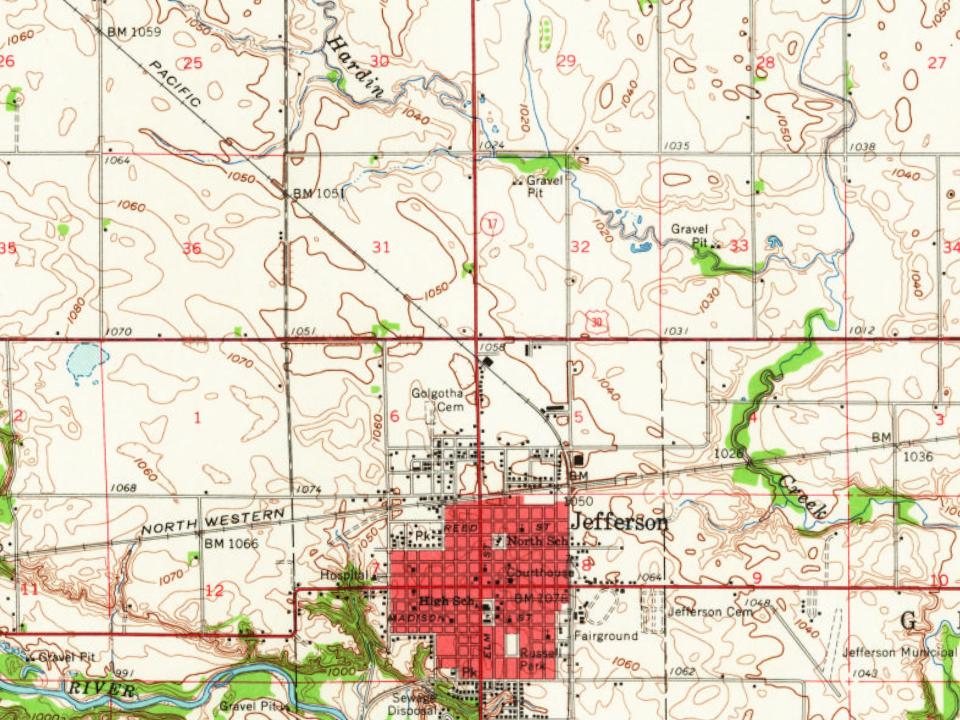
Founding dates: Wikidata, Wikipedia, the U.S. post office records of Blevins & Helbock (CC0) and the Census. Homes by year built: Census ACS 2020–24. National Register of Historic Places: National Park Service (list of May 22, 2026). Old photos, postcards and papers: Wikimedia Commons, the Library of Congress and other public archives, credited on each item’s page. Maps: U.S. Geological Survey historical topographic maps (via Esri) and Sanborn fire-insurance maps (Library of Congress). History text and census tables: Wikipedia (CC BY-SA 4.0). Places that used to be: USGS Geographic Names Information System (2021).
From Wikimedia Commons (3), the Library of Congress (2), Wikidata (1), the National Register of Historic Places (6), Wikipedia, Wikidata and Wikipedia for famous people, U.S. Geological Survey historical maps, U.S. Census counts (via Wikipedia), the US Post Offices dataset (Blevins & Helbock), the USGS Geographic Names Information System, Sanborn fire insurance maps (Library of Congress) and old county and town histories (Internet Archive). Archive images are copied here with their credits and licenses, shown on each photo’s page. Refreshed monthly.



 1907
 1907
 1907