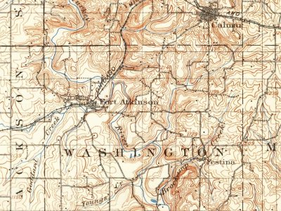
Every edition of the U.S. Geological Survey’s map of Fort Atkinson. Tap a year, or press play to watch the town change.
1906Decorah sheet · 1:125,000
U.S. Geological Survey historical topographic maps (public domain), via Esri’s collection of the scans. The red ring marks the center of Fort Atkinson.
Timeline
Fort Atkinson, 1846 to 1906
Woven from the archive, old maps, post office records, the National Register and the people born here.
Fort Atkinson was built to protect the Ho-Chunk (Winnebago) during their removal from Wisconsin. The name honors Henry Atkinson, the commanding officer in charge of the effort. Construction began in May 1840 and was complete by the summer of 1842. The regular army turned the fort over to Iowa volunteers as the troops stationed there were needed for the Mexican–American War. After the Ho-Chunk were removed from Iowa the post was abandoned on February 14, 1849.
Passages that mention Fort Atkinson, cut from the printed page as they were published.
History of Winneshiek county with biographical sketches of its eminent men1877 · page 74Read the page →
Read the text
The fort was built tor the protection of the Winnebago Indians from the hostile and predatory tribes surrounding them, as well as for the protection of the pioneer settlers. It was stone masonry work, situated on an eminence north of the present town of Fort Atkinson, and origin-
Text read by machine from the scan; it may contain errors.
History of Winneshiek county with biographical sketches of its eminent men1877 · page 79Read the page →
Read the text
The Flowers were extraordinary characters, and played no little part in the history of Fort Atkinson. There were two brothers of them, and were classed with Charley Clark, Coleman and Tavernier, as "the Canadians." These Canadians came to the fort with the intention of making a living easily. They had somehow got the impression that Fort Atkinson was destined to be a great city, and thought it afforded a rich field in which to exercise their wit and shrewdness to benefit themselves. In language not to be misunderstood, they were sharpers.
Text read by machine from the scan; it may contain errors.
Scans and text from the Internet Archive. Books published in 1930 or earlier, which are in the public domain.
Founding dates: Wikidata, Wikipedia, the U.S. post office records of Blevins & Helbock (CC0) and the Census. Homes by year built: Census ACS 2020–24. National Register of Historic Places: National Park Service (list of May 22, 2026). Old photos, postcards and papers: Wikimedia Commons, the Library of Congress and other public archives, credited on each item’s page. Maps: U.S. Geological Survey historical topographic maps (via Esri) and Sanborn fire-insurance maps (Library of Congress). History text and census tables: Wikipedia (CC BY-SA 4.0). Places that used to be: USGS Geographic Names Information System (2021). How TownRatings grades history →
From Wikimedia Commons (3), Wikidata (1), the National Register of Historic Places (1), Wikipedia, Wikidata and Wikipedia for famous people, U.S. Geological Survey historical maps, U.S. Census counts (via Wikipedia), the US Post Offices dataset (Blevins & Helbock), the USGS Geographic Names Information System, Sanborn fire insurance maps (Library of Congress) and old county and town histories (Internet Archive). Archive images are copied here with their credits and licenses, shown on each photo’s page. Refreshed monthly.




 2024
 2021
 2004

