The Dysart post office opened in 1873, the earliest record of the town by name. Another post office, Ettie (1869), opened inside today’s city and later closed.
First census: 516 in 18802020 census: 1,281153 years
How historic is Dysart?
B−
More historic than 52% of U.S. towns, on its age, its old homes and the National Register.
Founding year: the first Dysart post office (Blevins & Helbock, CC0).The full story ↓
History grade
What drives Dysart’s History grade
On its age, its old homes and the National Register, Dysart is more historic than 52% of U.S. towns. Its share of homes from before 1940 holds the grade up; its National Register listings pull it down.
B−
HistoryA character grade: shown, never part of Dysart’s overall grade.
Iowa towns list more on the Register than most of the country (a typical Iowa town has 9.1 per 10,000 residents, the U.S. 2.4), so Dysart’s 0.0 sits below most of its state (17% of Iowa towns have fewer) while its 0 listings outnumber those of 23% of U.S. towns.
How sure. Graded on any two of the three inputs instead, the letter would range from D to B+. The pre-1940 share is a Census survey estimate (±5.6 points). The founding year is the first post office, not a stated founding date.
Founding year: the first post office (other dates in Quick answers). Homes: Census ACS 2020–24. National Register: National Park Service, May 2026 list; each listing counted once (boundary changes and added documentation belong to their listing), and a historic district counts its contributing buildings. How TownRatings grades history →
What stands out about Dysart’s past
Read from the archive, the National Register and the record. The page puts what stands out first.
Fire insurance maps drew every building, what it was made of and what it was used for, so insurers could price the risk of fire. Pick a year, then a sheet.
1895Sheet 1 of 1
Edition
Sheets
BrickWoodStone
Sanborn Map Company, via the Library of Congress. Editions published in 1930 or earlier, which are in the public domain.
Dysart got its start in the year 1872, following construction of the Burlington, Cedar Rapids and Northern Railway through the territory. Dysart was platted in 1872. The town takes its name from Joseph Dysart, a farmer and founder of the town.
Passages that mention Dysart, cut from the printed page as they were published.
history of tama county, iowa its cities, towns and villages1879 · page 187Read the page →
Read the text
The Presbyterian society of this place was organized ut Yankee Grove, Benton County, in the year 1860. When the town of Dysart was established the congregation changed its place of worship to that town. In the year 1873 a church was built at a cost of $3,000, which was dedicated by Rev. S. Phelps, assisted by Rev. D. L. Hughes, who has labored with the congregation from that time to the present, and is a well known and well edu-
Text read by machine from the scan; it may contain errors.
History of Tama County, Iowa. Its cities, towns and villages, with early reminiscences, personal incidents and anecdotes and a complete business directory of the county1879 · page 187Read the page →
Read the text
The Presbyterian society of this place was organized at Yankee Grove, Benton County, in the year 1860. When the town of Dysart was established the congregation changed its place of worship to that town. In the year 1873 a church was built at a cost of $3,000, which was dedicated by Rev, S, Phelps, assisted by Rev, D, L, Hughes, who has labored with the congregation from that time to the present, and is a well known and well edu-
Text read by machine from the scan; it may contain errors.
History of Tama County, Iowa. Its cities, towns and villages, with early reminiscences, personal incidents and anecdotes and a complete business directory of the county1879 · page 180Read the page →
Read the text
The Dysart Reporter. — This is a seven column folio established in 1878, by T. N. Ives, and is the first paper published in the town of Dysart; the first nurabei" of which bears date of March 20th, 1878. Its editor and proprietor, Mr. Ives, is publishing one among the finest papers in the County, is well printed and is an honor lo the town. It has a good advertising patronage and a laige circulation for the time it has been in existence. It is an Independent advocator.
Text read by machine from the scan; it may contain errors.
history of tama county, iowa its cities, towns and villages1879 · page 180Read the page →
Read the text
The Dysart Reporter.—This is a seven column folioestablished in 1878, by T. N. Ives, and is the first paper published in the town of Dysart; the first number of which bears date of March 20th, 1878. Its editor and proprietor, Mr. Ives, is publishing one among the finest papers in the Connty, is well printed and is an honor to the town. It has a good advertising patronage and a large circulation for the time it has been in existence. It is an Independent advocator.
Text read by machine from the scan; it may contain errors.
Scans and text from the Internet Archive. Books published in 1930 or earlier, which are in the public domain.
Timeline
Dysart, 1869 to 1971
Woven from the archive, old maps, post office records, the National Register and the people born here.
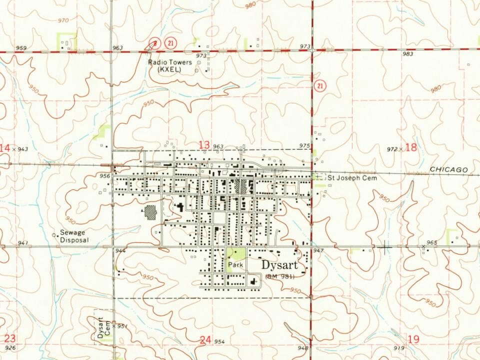
Every edition of the U.S. Geological Survey’s map of Dysart. Tap a year, or press play to watch the town change.
1971Dysart sheet · 1:24,000
U.S. Geological Survey historical topographic maps (public domain), via Esri’s collection of the scans. The red ring marks the center of Dysart.
People over time
Dysart, census by census
Between 516 and 1,379 people in every census since 1880.
15 censuses, 1880–2020.
U.S. Census Bureau decennial counts, from the census table on Dysart’s Wikipedia page.
Places that used to be
Lost post offices and places now gone
Dysart’s post office has been open since 1873. Another post office, Ettie, opened and closed inside today’s town.
Ettie
1869–1873
Dysart
1873–today
18601940today
Gone or out of use
Dysartlocale
US Post Offices dataset (Blevins & Helbock, CC0). Places and cemeteries from the USGS Geographic Names Information System (2021).
Questions about Dysart’s history
What year was Dysart founded?
The Dysart post office opened in 1873, the earliest record of the town by name (U.S. post office records).
How does Dysart rank for history?
Dysart is more historic than 52% of U.S. towns. The History grade combines the town’s founding era, the share of homes built before 1940 and its National Register listings. It’s a character grade, so it isn’t part of the overall grade. How it works.
How old are the homes in Dysart?
44% of Dysart’s homes were built before 1940 (Census estimate, ±5.6 points), against a typical 22% for an Iowa town; the median home was built in 1951.
Founding dates: Wikidata, Wikipedia, the U.S. post office records of Blevins & Helbock (CC0) and the Census. Homes by year built: Census ACS 2020–24. National Register of Historic Places: National Park Service (list of May 22, 2026). Old photos, postcards and papers: Wikimedia Commons, the Library of Congress and other public archives, credited on each item’s page. Maps: U.S. Geological Survey historical topographic maps (via Esri) and Sanborn fire-insurance maps (Library of Congress). History text and census tables: Wikipedia (CC BY-SA 4.0). Places that used to be: USGS Geographic Names Information System (2021).
From Wikimedia Commons (2), Wikipedia, Wikidata and Wikipedia for famous people, U.S. Geological Survey historical maps, U.S. Census counts (via Wikipedia), the US Post Offices dataset (Blevins & Helbock), the USGS Geographic Names Information System, Sanborn fire insurance maps (Library of Congress) and old county and town histories (Internet Archive). Archive images are copied here with their credits and licenses, shown on each photo’s page. Refreshed monthly.


 2021
 2004