Dyersville dates to 1851, and 14% of its homes were built before 1940
More historic than 51% of U.S. towns · #101 of 140 in Iowa. What drives it
Its Register listings are the Allen House and the Basilica of St. Francis Xavier, Church and Rectory. Below: 4 old photos and papers, maps from 1900 on, and the census since 1880.
Founding year: Wikidata; Wikipedia’s history section gives the same year. First post office: 1854. Name: Wikipedia, licensed CC BY-SA 4.0.The full story ↓
History grade
What drives Dyersville’s History grade
On its age, its old homes and the National Register, Dyersville is more historic than 51% of U.S. towns, #101 of 140 in Iowa. Its National Register listings hold the grade up; its age pulls it down.
B−
HistoryA character grade: shown, never part of Dyersville’s overall grade.
Iowa towns list more on the Register than most of the country (a typical Iowa town has 9.1 per 10,000 residents, the U.S. 2.4), so Dyersville’s 6.8 sits near the middle of its state (50% of Iowa towns have fewer) while its 3 historic buildings outnumber those of 65% of U.S. towns.
How sure. Graded on any two of the three inputs instead, the letter would range from C+ to B. The pre-1940 share is a Census survey estimate (±5.6 points). Two sources give 1851.
Founding year: Wikidata (other dates in Quick answers). Homes: Census ACS 2020–24. National Register: National Park Service, May 2026 list; each listing counted once (boundary changes and added documentation belong to their listing), and a historic district counts its contributing buildings. How TownRatings grades history →
What stands out about Dyersville’s past
Read from the archive, the National Register and the record. The page puts what stands out first.
Dyersville was laid out in 1851. It was named for early landowner James Dyer (1820–1864). Dyer immigrated from Banwell, England and established a hotel, The Clarendon, in 1857. His sons, James Andrew Dyer, with 6th Iowa Cavalry Regiment and Henry Andrew Dyer, with 21st Iowa Infantry Regiment, served in the American Civil War.
Passages that mention Dyersville, cut from the printed page as they were published.
History of Dubuque County, Iowa1911 · page 876Read the page →
Read the text
tentious structure of solid stone was constructed and was dedicated in 1855 by Bishop Smyth. The last church was built in 1884-7 after which the old church of 1855 was devoted to school purposes. St. Francis Xavier church at Dyersville was an offspring of St. Boniface church. So was Holy Trinity at Luxemburg and others. The present church is one of the finest in the west. It cost $80,000, is built of limestone, gothic in style and 172x62 feet.
Text read by machine from the scan; it may contain errors.
The history of Dubuque County, Iowa1880 · page 701Read the page →
Read the text
At a distance of twenty-nine miles west of Dubuque, and by the wayside of the Iowa Division of the Illinois Central Railroad, is the flourishing and beautifully located town of Dyersville, situated on a prominent eminence in the western portion of Dubuque County, commanding an extensive view of the surrounding country. The town is nearly encircled by a large belt of forest timber, while the beautiful and undulating prairies beyond, rolling away in the distance, dotted here and there with numerous pine groves, present to the eye of the observer a combination of beauty and majesty rivaled by no country in
Text read by machine from the scan; it may contain errors.
Francis Seminary. Alilwaukee. where, on March 16. 1872, he was ordained to the priesthood ; succeeding which, in regular order, he was stationed at Keokuk. Richmond, Centralia, Worthington, Dyersville and Dubuque, but it was in this county that he became most widely known. Through his instrumentality the church and school at Worthington were built ; at Dyersville he remodeled the church, established a high school and founded an academy for girls.
Text read by machine from the scan; it may contain errors.
The history of Dubuque County, Iowa1880 · page 710Read the page →
Read the text
In the year 1849, James Dyer, Sr., fitted up an apartment in one of his houses for church and Sabbath-school purposes. The location was one mile east of the present town of Dyersville, near the cemetery, in which the Rev. William Trick, Sr., preached regularly and held class and Sabbath school for a number of years.
Text read by machine from the scan; it may contain errors.
Scans and text from the Internet Archive. Books published in 1930 or earlier, which are in the public domain.
Timeline
Dyersville, 1851 to 1996
Woven from the archive, old maps, post office records, the National Register and the people born here.
Nothing in the archives for these yearsWeddings on Main Street, storms, parades, school pictures, the old store. If it’s in your family album, it belongs here.
Fire insurance maps drew every building, what it was made of and what it was used for, so insurers could price the risk of fire. Pick a year, then a sheet.
Dyersville’s post office has been open since 1854.
Hamlets and corners on the map
Northwind Mobile Home ParkSummit Village Dyersville Park
2cemeteries and burying grounds inside Dyersville
Saint FrancisVanduesen
US Post Offices dataset (Blevins & Helbock, CC0). Places and cemeteries from the USGS Geographic Names Information System (2021).
Questions about Dyersville’s history
What year was Dyersville founded?
In 1851, according to Wikidata and Wikipedia’s history of the town. Dyersville’s post office opened in 1854, and the census of 1880 counted 975 people here.
How does Dyersville rank for history?
Dyersville is more historic than 51% of U.S. towns, #101 of 140 in Iowa. The History grade combines the town’s founding era, the share of homes built before 1940 and its National Register listings. It’s a character grade, so it isn’t part of the overall grade. How it works.
What is on the National Register in Dyersville?
Two places: the Allen House (listed 1975) and the Basilica of St. Francis Xavier, Church and Rectory (1999).
How old are the homes in Dyersville?
14% of Dyersville’s homes were built before 1940 (Census estimate, ±5.6 points), against a typical 22% for an Iowa town; the median home was built in 1975.
Founding dates: Wikidata, Wikipedia, the U.S. post office records of Blevins & Helbock (CC0) and the Census. Homes by year built: Census ACS 2020–24. National Register of Historic Places: National Park Service (list of May 22, 2026). Old photos, postcards and papers: Wikimedia Commons, the Library of Congress and other public archives, credited on each item’s page. Maps: U.S. Geological Survey historical topographic maps (via Esri) and Sanborn fire-insurance maps (Library of Congress). History text and census tables: Wikipedia (CC BY-SA 4.0). Places that used to be: USGS Geographic Names Information System (2021).
From Wikimedia Commons (4), the Library of Congress (1), Wikidata (1), the National Register of Historic Places (2), Wikipedia, Wikidata and Wikipedia for famous people, U.S. Geological Survey historical maps, U.S. Census counts (via Wikipedia), the US Post Offices dataset (Blevins & Helbock), the USGS Geographic Names Information System, Sanborn fire insurance maps (Library of Congress) and old county and town histories (Internet Archive). Archive images are copied here with their credits and licenses, shown on each photo’s page. Refreshed monthly.


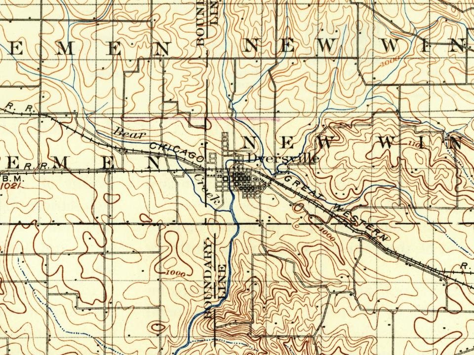
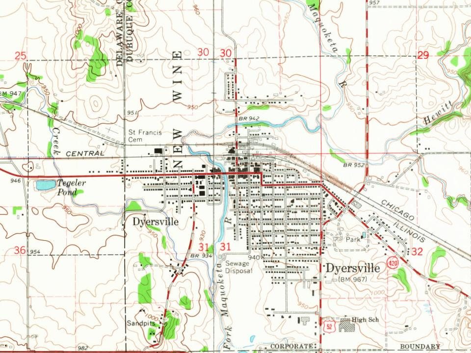
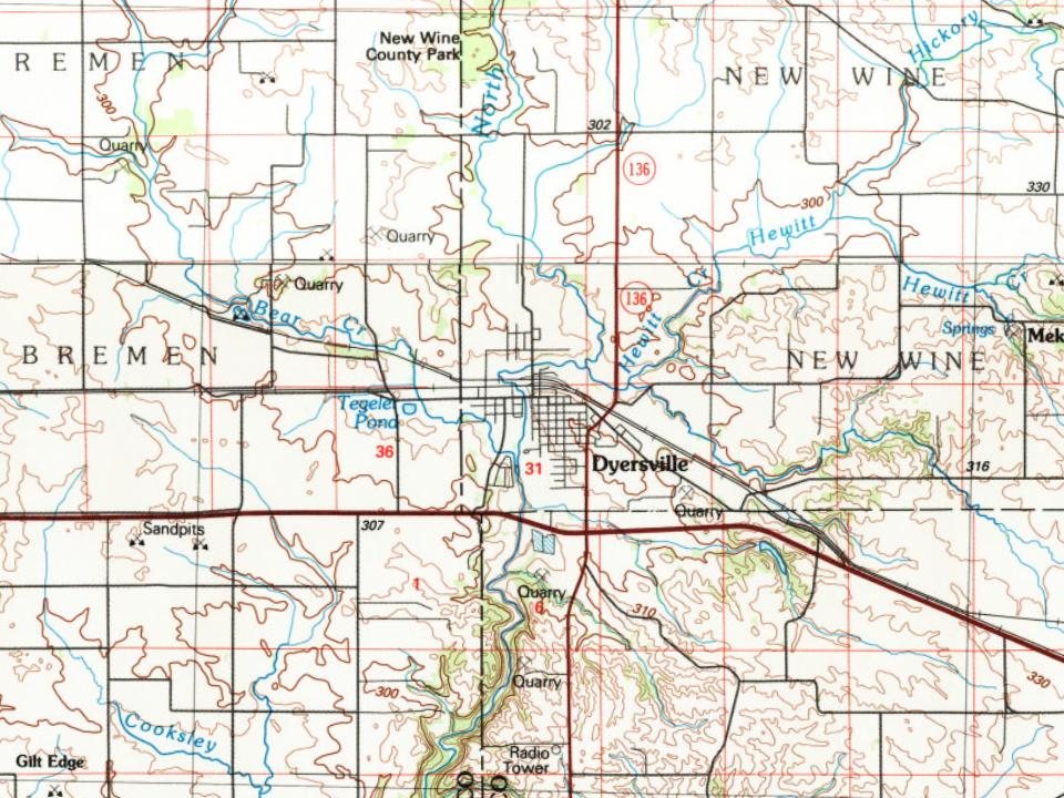




 1912
 2003

