


The story
Read it all →How Hogansville came to be
From Wikipedia’s history of Hogansville.
The community was named after William Hogan, owner of the original town site.
Text from Wikipedia, licensed CC BY-SA 4.0.
Each edition grades its towns against each other only.
More historic than 95% of U.S. towns · #4 of 263 in Georgia. What drives it
5 places in town are on the National Register, among them two historic districts with 414 buildings between them. Below: 10 old photos and papers, maps from 1898 on, and the census since 1880.
The Hogansville post office opened in 1847, the earliest record of the town by name.
More historic than 95% of U.S. towns, on its age, its old homes and the National Register.
On its age, its old homes and the National Register, Hogansville is more historic than 95% of U.S. towns, #4 of 263 in Georgia. All 3 inputs are above most U.S. towns; its National Register listings ranks highest and its age lowest.
Georgia towns list more on the Register than most of the country (a typical Georgia town has 10.0 per 10,000 residents, the U.S. 2.4), so Hogansville’s 1,294 sits above most of its state (97% of Georgia towns have fewer) while its 420 historic buildings outnumber those of 97% of U.S. towns.
Founding year: the first post office (other dates in Quick answers). Homes: Census ACS 2020–24. National Register: National Park Service, May 2026 list; each listing counted once (boundary changes and added documentation belong to their listing), and a historic district counts its contributing buildings. How TownRatings grades history →
Read from the archive, the National Register and the record. The page puts what stands out first.
The country’s official list of buildings and places worth saving.
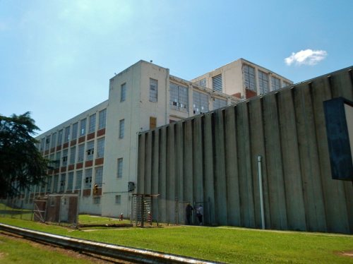


National Park Service, National Register of Historic Places. Photos from Wikimedia Commons, credited on each place’s page.
Fire insurance maps drew every building, what it was made of and what it was used for, so insurers could price the risk of fire. Pick a year, then a sheet.
 1898Sheet 1 of 1
Sanborn Map Company, via the Library of Congress. Editions published in 1930 or earlier, which are in the public domain.
Woven from the archive, old maps, post office records, the National Register and the people born here.
 Born hereDerek Smith is born here
 On the mapFirst mapped by the U.S. Geological Survey
 In the archiveEXTERIOR VIEW OF BOILER HOUSE FROM SOUTHWEST. THE BOILER HOUSE WAS USED FOR HEATING THE M…
 In the archiveDETAIL VIEW OF MAIN ELEVATION OF MILL, LOOKING NORTHWEST. NOTE ORIGINAL WINDOWS ON UPPER …
From Wikipedia’s history of Hogansville.
The community was named after William Hogan, owner of the original town site.
Text from Wikipedia, licensed CC BY-SA 4.0.
2 decades in the archive, from the 1960s to the 1990s. Scroll each row; tap a photo for its story.
1968EXTERIOR VIEW OF BOILER HOUSE FROM SOUTHWEST. THE BOI…1998DETAIL VIEW OF MAIN ELEVATION OF MILL, LOOKING NORTHW… 1998INTERIOR OF SECOND FLOOR NEAR CENTER OF BUILDING. THI…
 1998INTERIOR OF THIRD FLOOR FROM CENTER FACING SOUTHWEST.…
 1998MOTOR AND DRIVE WHEEL FOR ONE SET OF FANS IN SOUTH VE…
 1998VIEW INSIDE ONE OF THE FAN CHAMBERS IN NORTH VENTILAT…
 1998VIEW OF SOUTHWEST-WEST ELEVATION OF MILL WITH WAREHOU…
 1998VIEW OF SOUTHWEST-WEST ELEVATION OF MILL WITH WAREHOU…
 1998VIEW OF VENTILATION HOUSES AND ROOF MONITOR FROM SOUT…
 1998VIEW OF WEST ELEVATION OF MILL (LEFT), AND PICKER HOU…
Every edition of the U.S. Geological Survey’s map of Hogansville. Tap a year, or press play to watch the town change.

U.S. Geological Survey historical topographic maps (public domain), via Esri’s collection of the scans. The red ring marks the center of Hogansville.
No then-and-now pairs yet. Take a photo from the same spot as an old one and they appear here side by side.

Find the spot, match the angle, and add your photo. It becomes the first then-and-now pair on Hogansville’s page.
Retake this view · +15Between 400 and 3,886 people in every census since 1880.
15 censuses, 1880–2020.
U.S. Census Bureau decennial counts, from the census table on Hogansville’s Wikipedia page.
Writers, athletes, leaders and more, ranked by how widely they’re known.
Hogansville’s post office has been open since 1847.
US Post Offices dataset (Blevins & Helbock, CC0). Places and cemeteries from the USGS Geographic Names Information System (2021).
Most archives stop around 1920. The photos from after that are in family albums, not libraries.
The Hogansville post office opened in 1847, the earliest record of the town by name (U.S. post office records).
Hogansville is more historic than 95% of U.S. towns, #4 of 263 in Georgia. The History grade combines the town’s founding era, the share of homes built before 1940 and its National Register listings. It’s a character grade, so it isn’t part of the overall grade. How it works.
5 listings: 3 buildings, among them the Phillips, William D., Log Cabin (listed 1982, the first), and 2 historic districts, the Stark Mill and Mill Village Historic District and the East Main Street-Johnson Street Historic District, with 414 contributing buildings. 420 historic buildings in all.
26% of Hogansville’s homes were built before 1940 (Census estimate, ±9.8 points), against a typical 3.8% for a Georgia town; the median home was built in 1979.
What the archives can’t tell you, neighbors can.
Founding dates: Wikidata, Wikipedia, the U.S. post office records of Blevins & Helbock (CC0) and the Census. Homes by year built: Census ACS 2020–24. National Register of Historic Places: National Park Service (list of May 22, 2026). Old photos, postcards and papers: Wikimedia Commons, the Library of Congress and other public archives, credited on each item’s page. Maps: U.S. Geological Survey historical topographic maps (via Esri) and Sanborn fire-insurance maps (Library of Congress). History text and census tables: Wikipedia (CC BY-SA 4.0). Places that used to be: USGS Geographic Names Information System (2021).
From Wikimedia Commons (12), the National Register of Historic Places (5), Wikipedia, Wikidata and Wikipedia for famous people, U.S. Geological Survey historical maps, U.S. Census counts (via Wikipedia), the US Post Offices dataset (Blevins & Helbock), the USGS Geographic Names Information System and Sanborn fire insurance maps (Library of Congress). Archive images are copied here with their credits and licenses, shown on each photo’s page. Refreshed monthly.
 2012
 2005


